A Geography for Beginners:
Electronic Edition.
Stewart, K. J. (Kensey Johns)
Funding from the Institute of Museum and Library
Services
supported the electronic publication of this title.
Text scanned (OCR) by
Gretchen Fricke
Images scanned by
Gretchen Fricke and Christie Mawhinney
Text encoded by
Christie Mawhinney and Jill Kuhn
First edition, 1999
ca. 500K
Academic Affairs Library, UNC-CH
University of North Carolina at Chapel Hill,
1999.

Source Description:
(title page) A Geography for Beginners.
(cover) Geography for Beginners
Rev. K. J. Stewart
viii, 223 p., [10] leaves of plates.
Richmond, Va.
J. W. Randloph.
1864
4107 Conf. (Rare Book Collection, University of North Carolina at Chapel Hill)
The electronic edition is a part of the UNC-CH
digitization project, Documenting the American South.
Quotation marks used to represent repeating text were replaced with the actual words.
All footnotes are inserted at the point of reference within paragraphs.
Any hyphens occurring in line breaks have been
removed, and the trailing part of a word has been joined to
the preceding line.
All quotation marks, em dashes and ampersand have been transcribed as
entity references.
All double right and left quotation marks are encoded as " and "
respectively.
All single right and left quotation marks are encoded as ' and ' respectively.
All em dashes are encoded as --
Indentation in lines has not been preserved.
Running titles have not been preserved.
Spell-check and verification made against printed text using Author/Editor (SoftQuad) and Microsoft Word spell check programs.
Languages Used:
- English
- French
- LC Subject Headings:
- Geography -- Juvenile literature.
- Education -- Confederate States of America.
- Textbooks -- Confederate States of America.
- Confederate States of America -- Juvenile literature.
- Southern States -- Juvenile literature.
Revision History:
- 2000-03-01,
Celine Noel and Wanda Gunther
revised TEIHeader and created catalog record for the electronic edition.
-
1999-12-28,
Jill Kuhn
finished TEI-conformant encoding and final proofing.
-
1999-12-17,
Christie Mawhinney
finished TEI/SGML encoding
- 1999-11-18,
Gretchen Fricke
finished scanning (OCR) and proofing.


THE WORLD.

STEWART'S
COURSE OF GEOGRAPHY:
COMPRISING
A COMPLETE SYSTEM OF INSTRUCTION
CONCERNING THE NATURAL AND POLITICAL DIVISIONS OF THE WORLD;
DESIGNED
TO AID THE STUDENT IN OBTAINING ACCURATE AND SYSTEMATIC INFORMATION
UPON ALL GEOGRAPHICAL SUBJECTS; AND SO ARRANGED AS TO AVOID TAXING
THE MEMORY WITH UNNECESSARY STATISTICAL DETAILS.
A
GEOGRAPHY FOR BEGINNERS.
BY THE
REV. K. J. STEWART.
PALMETTO SERIES.
ILLUSTRATED WITH MAPS AND ENGRAVINGS.
RICHMOND, VA.:
J. W. RANDOLPH.
M.DCCC.LXIV.
Page v
PREFACE.
EDUCATION consists not merely in the acquisition of knowledge, but also, and chiefly, in learning to observe accurately and systematically.
It is the design of this book, and the series of books of which it forms a part, to aid the Teacher in educating his Pupil, as well as to impart useful knowledge.
And, inasmuch as all valuable attainments must be the result of labour, and therefore the Scholar must master certain things in order to attain a knowledge of Geography, these are given in the concise form of a Dictionary, which should be memorized before the Pupil advances further.
In the present volume, systematic arrangement is preserved as far as practicable; but, inasmuch as it is merely an introduction to the other volumes, a perfect method in its details cannot always be accomplished.
Page vi
The Author is indebted to the Hon. John Perkins, of Louisiana; G. W. Randolph, John Prosser Tabb, M.D.; Rev. Messrs. Phillips and Gatewood, of Virginia; and to others, for valuable aid in commencing the series of which this volume is the forerunner.
In acknowledging his obligations to preceding Authors, he would state that it has not been his object to depart either from the facts or the words of the best Geographers, except where greater conciseness might be gained.
Page vii
CONTENTS.
- 1. GENERAL DEFINITIONS ..... 1
- 2. MAPS ..... 11
- 3. NORTH AMERICA ..... 12
- 4. THE GREAT WATER-SHEDS OF NORTH AMERICA ..... 15
- 5. THE EASTERN ALLEGHANY WATER-SHEDS ..... 17
- 6. THE WESTERN WATER-SHED OF THE ROCKY MOUNTAINS ..... 18
- 7. THE LAKES OF NORTH AMERICA, AND ITS INLAND SEAS ..... 19
- 8. ISLANDS ..... 21
- 9. MINERALS, METALS, &c...... 22
- 10. THE VEGETABLE KINGDOM ..... 24
- 11. THE ANIMAL KINGDOM ..... 25
- 12. BIRDS ..... 28
- 13. MAN ..... 29
- 14. DIVISIONS OF THE HUMAN RACE ..... 31
- 15. POLITICAL DIVISIONS ..... 35
- 16. GOVERNMENTS ..... 36
- 17. THE CITIES OF THE WORLD ..... 38
- 18. HISTORY OF THE CONFEDERATE STATES ..... 40
- 19. THE PRODUCTIONS OF THE CONFEDERATE STATES ..... 44
- 20. THE FLORA OF THE CONFEDERATE STATES ..... 48
- 21. THE SCENERY OF THE CONFEDERATE STATES ..... 49
- 22. THE FAUNA OF THE CONFEDERATE STATES ..... 50
- 23. THE MANUFACTURES OF THE CONFEDERATE STATES ..... 52
- 24. GREAT BRITAIN AND IRELAND ..... 53
- 25. THE CONTINENT OF EUROPE ..... 67
- 26. FRANCE ..... 68
Page viii - 27. NORWAY AND SWEDEN ..... 71
- 28. RUSSIA ..... 77
- 29. EUROPEAN TURKEY AND GREECE ..... 81
- 30. AUSTRIA ..... 84
- 31. ITALY ..... 89
- 32. SPAIN AND PORTUGAL ..... 92
- 33. BELGIUM, HOLLAND, AND GERMANY ..... 94
- 34. DENMARK, PRUSSIA, AND SWITZERLAND ..... 101
- 35. ASIA AND AUSTRALIA, &c. ..... 105
- 36. ARABIA, PERSIA, INDIA, CHINA, &c. ..... 112
- 37. PALESTINE ..... 123
- 38. AFRICA ..... 126
- 39. SOUTH AMERICA .....146
- 40. MEXICO, CENTRAL AMERICA, &c. ..... 161
- 41. THE WEST INDIES ..... 165
- 42. THE BRITISH POSSESSIONS IN NORTH AMERICA..... 173
- 43. DANISH AMERICA ..... 179
- 44. THE SOUTHERN STATES ..... 180
- 45. THE UNITED STATES ..... 197
- 46. THE NEW ENGLAND STATES ..... 200
- 47. THE MIDDLE STATES ..... 207
- 48. THE WESTERN STATES ..... 213
- 49. THE TERRITORIES ..... 221
- NORTH AMERICA ..... 13
- EUROPE ..... 69
- ASIA ..... 107
- AFRICA ..... 127
- SOUTH AMERICA ..... 147
MAPS.
Page 1
A GEOGRAPHY FOR BEGINNERS.
SECTION I.--General Definitions.
GEOGRAPHY, a description of the surface of the earth.
NATURAL, caused by the laws of nature--God's handiwork.
POLITICAL, caused by the laws of man.
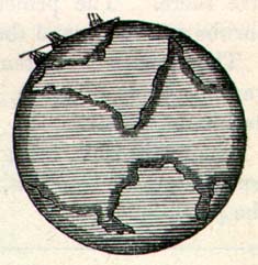
GEOLOGY, a description of the strata, or layers of earth, stone, metals, &c. of which the earth's crust is composed.

STRATA AN BROKEN STRATA.
SEA, a large body of water.
LAKE, a large body of fresh water (rarely salt water).
OCEAN, a large sea--the mother of seas.
STRAIT, a narrow channel, or water-passage, connecting seas or lakes.
CHANNEL, a wide strait, or water-passage.
Page 2
CANAL, an artificial water-passage.

A CANAL.
LOCK, the portion of a canal between two flood-gates.

A LOCK.
GULF, a large body of salt water, almost surrounded by land.
BAY, a large body of water, opening into a sea or lake.
Page 3
RIVER, a stream of water flowing into the sea.

A RIVER.
CREEK, a small river; also, an inlet.
SOUND, a bay or frith; a great inlet of the sea with anchorage.
ROADSTEAD, a portion of a bay, where ships can find anchorage.
FRITH, a wide mouth of a river; an estuary.
TIDE, the semi-daily rise and fall of the sea.
SHOALS, shallow places where there is little depth of water.
CONTINENT, a large tract of land.
ISLAND, a portion of land, surrounded by water.
MAP, a picture of the earth's surface.

PENINSULA, land almost surrounded by water.
Page 4
ARCHIPELAGO, a group of islands.
CAPE, a point of land extending out into the sea.
PROMONTORY, a high bluff extending towards the sea.
ISTHMUS, a narrow neck of land.
BANKS, shores of a river; shoals in the sea; shallow places.
SHORE, the portion of land that forms the border of seas, rivers, &c.
REEF, a low ledge of rocks extending out into the sea.
INLET, an arm of the sea projecting into the land; a short water-passage between two bodies of water.
ESTUARY, a large inlet; an arm of the sea into which rivers flow.
HARBOUR, a safe shelter for ships.
DOCK, an artificial harbour.
AQUEDUCT, an artificial water-passage; a canal.
BRIDGE, a passage over water; a structure over a chasm.
TORRENT, the rushing of water through the chasms of hills.
CATARACT, a large waterfall.
FRESHET, a great rise of a river after heavy rain-falls.
SWAMP, low, wet land.
DELTA,*
*The word Delta is the name of the fourth letter in the Greek alphabet, having the same sound with D in the English alphabet. The shape of the letter is like a triangle. The name is applied to any portion of land separated from the main land by a river which has two or more mouths. The River Nile, just before its entrance into the Mediterranean, separates, and flows into the sea by several branches. The land between these branches is called the Delta, from its resembling in shape the Greek  .
.
the soil deposited by settlings from the muddy waters of a river. These deltas often become bars, and obstruct navigation at the mouth of a river; sometimes they form large islands.
NAUTICAL, appertaining to the sea.
NAVIGABLE, capable of bearing ships. Some vessels require only two or three feet of water to float them; others require twenty-five feet.
NAVIGATION, the art of sailing ships.
Page 5
SHIP, a boat or vessel of the largest class, having three or more masts; a large steamboat.
BRIG, a vessel of the 2nd class, having two masts, and square sails.
SLOOP, a vessel of the 3rd class.
SCHOONER, a small brig, but differently rigged.

A SHIP, BRIG, AND SLOOP.
MOUNTAIN, a high hill.
CHAIN, RANGE, a long series of mountains.
RIDGE, the high backbone of hills or mountains.
SPUR, a mountain jutting out from a range.

RANGE OF MOUNTAINS.
Page 6
VALLEY, space between hills.
PASS, a road through a range of hills.
TABLE-LAND, high plains.
PEAK, CLIFF, the summit of a hill.

HILLS AND MOUNTAINS.
VOLCANO, a mountain sending forth fire and smoke.

A VOLCANO.
Page 7
LAVA, the molten mass of earths that come from a volcano.
STALACTITE, a crystalline column, or drop, formed from the roofs of caverns.
EARTHQUAKE, violent shaking of the crust of the earth.

AN EARTHQUAKE.
GLOBE, a round ball, representing the world on which we live.
SPHERE, a round body, every point of its surface equi-distant from its centre.
HEMISPHERE, half a sphere.
HORIZON, the distant line which terminates the view.
DIAMETER, the distance through a globe or circle; a straight line through the centre of a circle.
CIRCUMFERENCE, the distance around a globe or circle.
LATITUDE, the distance north or south of the equator.
HIGH LATITUDE, very far from the equator, up towards the poles.
LONGITUDE, the distance east or west (usually measured from Greenwich, England.)*
* Greenwich is a south-eastern suburb of London. There is in Greenwich a Royal Observatory, where astronomical and geographical calculations are made, and the longitude for English navigators is computed from this place. As Greenwich is very near London, the most noted city in the world, the longitude computed from Greenwich is generally called the longitude from London. In many Atlases, the longitude on the map of the world is represented as the "Longitude from London," while in other maps it is expressed as the "Longitude from Greenwich."
Page 8
POLES, the extremities of the axis of the earth.
NORTH POLE, SOUTH POLE, the ends of a line passing through the centre of the earth.
AXIS, the line around which a sphere moves.

Axis
EQUATOR, the line which passes around the earth at equal distances between the poles.
LATITUDES AND LONGITUDES are lines passing round the earth, east and west, and north and south, and used to measure distances.
MERIDIAN, that longitude which passes directly over the observer.
ZONES, belts of the earth's surface.

ZONES
TORRID, hot.
FRIGID, cold.
TEMPERATE, moderate, mild.
The climate of the frigid zones is very cold; the winter lasting nine months. The fine fruits, flowers, and trees of the temperate zones cannot live there. The principal growth is that of shrubs and moss, and the hardy kind of firs.
The climate of the temperate zones, being more mild, is the home of various kinds of grain, a great variety of fruit and flowers, and the deciduous trees.
The torrid zone, being very hot, is the home of the alligator, the boa-constrictor, the elephant, and the lion. There the sugar-cane flourishes, the pine-apple, &c.
Page 9
DEGREES are usually expressed thus:-- 2 deg. or 2°; MINUTES, 2 min., or 2'; SECONDS, 2 sec., or 2".
MILE, 5280 feet, 1-60th part of a degree; in geography one minute (1').
KNOTS, nautical miles.
LEAGUE, 3 miles.
CHRISTENDOM, the civilized and christianized parts of the world.
PAGAN, HEATHEN, a superstitious worshipper of idols.
MOHAMMED, the false prophet of Mecca.
MOHAMMEDAN, follower of Mohammed.
NEGROES, black people.
MOORS, people of Northern Africa.
CAUCASIANS, the white races.
MALAYS, the semi-negroes of the East Indies.
MONGOLIANS, a people of Asia.
CHURCH, a temple consecrated to the worship of God.
CATHEDRAL, an Episcopal Church.
KIRK, the Church of Scotland.
SYNAGOGUE, a Jewish Church.
MOSQUE, a Mohammedan Church.
COLLEGE, UNIVERSITY, SEMINARY; schools of learning.
MERCHANT, one who trades with foreign countries; a wholesale dealer in merchandise.
MERCHANDISE, traffic; commerce; goods.
TRADE, barter of goods, buying and selling merchandise.
MANUFACTURES, products of labour in factories, &c.
FACTORY, a place where fabrics are made.
LUMBER, boards, planks, building material.
GAME, wild animals, fowls, &c.
CWT., 112 pounds.
TON, 20 cwt., or 2,240 pounds.
TRANSPORT, to convey from one place to another.
GRAIN, corn, wheat, barley, &c.
FAUNA, the animals peculiar to a country.
FLORA, the vegetable productions peculiar to a country.
Page 10
PLAIN, a level tract of land.
FOREST, an extensive wood.
PRAIRIE, PAMPAS, a large natural meadow.

PRAIRIE ON FIRE
DESERT, a tract of barren, unfruitful land.
MEADOW, a grass field.
VIA, by way of; through.
REGION, a portion of land; a large tract of country.
TERRITORY, portions of country belonging to a realm.
COLONY, a settlement.
CAPITAL, the seat of government.
CAPITOL, the hall of legislation.
PALACE, a royal residence.
METROPOLIS, the great emporium of trade and commerce.
STORM, a very high wind, usually with rain.
HURRICANE, tornado, tempest; an extraordinary storm.
SQUALL, a sudden and tempestuous storm.
Page 11
EMPEROR, MONARCH, KING, SULTAN, CALIPH, CZAR, GRANDDUKE, ELECTOR, PRINCE, PRESIDENT, GOVERNOR, VICEROY; terms designating rulers of nations.
EMPIRE, KINGDOM, REALM, COMMONWEALTH, STATE, REPUBLIC, PRINCIPALITY, DUCHY, &c.; names of different forms of government and nationalities.
PARLIAMENT, DIET, CONGRESS, LEGISLATURE, COUNCIL, SENATE, &c.; national assemblies for making laws, &c.
MILITARY OFFICERS, &c.:--
Army--General, Commanding-in-Chief, Field-Marshal; Lieutenant-General, commanding a corps; Major-General, commanding a division; Brigadier-General, commanding a brigade; Colonel, commanding a regiment; Lieutenant-Colonel, commanding-assistant; Major, commanding-assistant; Captain, commanding a company; Lieutenant, Sergeant, &c., commanding parts of a company.
Navy--Lord High Admiral; Admiral, Rear-Admiral; Commodore, Commander; Post-Captain, Lieutenant, Midshipman.
CONSTITUTION, CHARTER, fundamental regulations designed to control and limit the authority of parliaments, kings, &c.
SECTION II.--Maps.
The map of the world shows two hemispheres--one is called "the Eastern," the other "the Western" Hemisphere.

Page 12
The Eastern Hemisphere comprises Europe, Asia, Africa, Australia, &c. The Western Hemisphere contains North and South America, the West Indies, and the Islands of the Pacific and South Seas.
The top of the map is north: the right hand, east; the bottom, south; the left hand, west.
The lines of latitude begin at the equator, and count upwards and downwards towards the poles.
The lines of longitude begin at Greenwich Observatory, London, England, and thence count east and west.
There are 360 parts in all circles, called degrees; they are usually marked thus--1°, 2°, 3°, &c.
The circles on the earth's surface are thus divided; and as the earth is nearly 25,000 miles round at the equator, each degree at that place being about 69 miles long, i.e 25000/360, every degree of latitude is of that length. But degrees of longitude become less as they approach the poles; thus at 60° north latitude, a degree of longitude is only 34 1/2 miles long, or but half the length of a degree at the equator.
- What is a hemisphere? (see DEFINITIONS.)
- Is the eastern hemisphere on the right hand of the map? Is the bottom of the map N. or S.?
- In which hemisphere is North America? South America? Africa? West Indies?
- Where do you begin to count the lines of latitude? Longitude?
- How many degrees in a circle? What is the length of a degree? This is the length at the equator; is it as long nearer the poles? At 60°?
- What is the equator? (see DEFINITIONS.) The poles? Latitude? Longitude?
- What is the latitude of Richmond? Charleston? Memphis?
- What do the marks mean--39° 31' 22" N. Latitude? (see DEFINITIONS.)
QUESTIONS.
SECTION III.--North America.
The map of North America shows you two great chains of mountains: one of them is called the Rocky Mountains; the other, the Alleghany Mountains. They were caused by the action of the internal fires of the earth, which, by coming in

NORTH AMERICA.
Page 15
contact with water and gases, and changing them into steam and vapour, burst upwards through the crust of the earth's surface, and exposed many strata of minerals and rock, which are very valuable to mankind. By this means, immense beds of coal are exposed, which Divine Providence had prepared, after the Genesis, and many thousands of years before Adam, while as yet the surface of the earth was unfit for the use of mankind. Immense stores of iron, lead, copper, &c. are also thus lifted up and exposed for man's use. Gold, and silver, and other precious metals, and various kinds of stones used in building and agriculture, are thus uplifted, and ready for use.
There are two kinds of coal, one of which is found near Richmond, Va.; and the other in Pennsylvania. The Richmond coal burns with smoke like tar or bitumen, and is called "bituminous coal;" the other burns without smoke, and is called "anthracite;" the anthracite is also called "hard coal."
The upheaving of these mountain ranges also occasioned all the diversity of hill and valley, and water-fall, &c., which adorn and beautify the scenery, conduce to health, and aid the farmer and the manufacturer in his work.
The variety of elevation thus produced, causes also a variety of climate; so that, in Texas and Mexico, people can change the hot climate of the torrid zone, to the pleasant air of our spring-time, by merely ascending the slope of a mountain or table land.
- What mountains are in Western America? In Eastern America?
- Who caused them to be uplifted? By what means?
- What is a volcano? (see DEFINITIONS.)
- What good results to man from mountains?
- Geology? (see DEFINITIONS.)
- Bituminous coal?
QUESTIONS.
SECTION IV.--The great Water-Sheds of North America.
In consequence of the similar direction of the mountain ranges of North America, their great length, and the nature of
Page 16
the country between them, nearly all the water that is shed from the eastern slope of the Rocky Mountains, and nearly all that comes from the western slope of the Alleghanies, finds its outlet, through the Mississippi River, to the Gulf of Mexico.
This is the longest, if not the largest, river of the world. From its extreme sources, where the Missouri rises among the Rocky Mountains, or where the Mississippi branch approaches the British possessions on the north, to the Gulf of Mexico, is about 4,000 miles. And its tributaries, which are very numerous, are themselves larger than many of the great rivers of other lands. The Ohio, which empties into the Mississippi, 1,000 miles from its mouth, is navigable for 1,000 miles above that point. The Tennessee, which empties into the Ohio, is navigable about 800 miles.
The principal branches of the Mississippi, that shed the water of the Rocky Mountains, are the following:--
- The RED RIVER,
- --ARKANSAS (pro. Arkansaw),
- --MISSOURI,
- THE WHITE RIVER,
- --ST. FRANCIS,
- --DESMOINES.
With their branches, such as--
- The CANADIAN,
- The PLATTE, &c.
Those which conduct the water from the Allegheny water-shed are the following:--
- The ILLINOIS,
- --WABASH,
- --OHIO,
- --TENNESSEE,
- --CUMBERLAND,
- The KENTUCKY,
- --KANAWHA,
- --ALLEGHANY,
- --MONONGAHELA.
If all, or a greater part, of these rivers were to rise at one time, the whole valley of the Mississippi would be submerged, from Lake Michigan to the Gulf of Mexico. And it often happens that that great river, which is nearly two miles wide and 100 feet deep, rises, by reason of the rains upon the mountains,
Page 17
to the height of forty and fifty feet above its lower level, and, overflowing the delta which it has deposited along its banks, it pours a mighty tide of muddy waters downward towards the Gulf, extending from 15 to 25 miles in breadth.
This river is connected, viâ the Illinois and Chicago Rivers, by a canal, with Lake Michigan.
- Which is the longest river in the world?
- Name the branches of the Mississippi river which rise in the Allegheny mountains.
- Name those which rise towards the Lake region.
- Those that rise among or near the Rocky Mountains.
- How many feet does the Mississippi River rise? How wide is it when it overflows its banks?
- What is the proper name for a great rise in a river? (see DEFINITIONS.)
- What is the length of the Mississippi from its extreme sources to the Gulf of Mexico?
QUESTIONS.
SECTION V.--The Eastern Allegheny Water-Sheds.
The chief rivers of the eastern slope of the Alleghany range are,--
- The ST. LAWRENCE,
- --CONNECTICUT,
- --HUDSON,
- --DELAWARE,
- --SUSQUEHANNA,
- --POTOMAC,
- --RAPPAHANNOCK,
- --JAMES,
- --The ROANOKE,
- --NEUSE,
- --CAPE FEAR,
- --TOMBIGBEE,
- --PEDEE,
- --SAVANNAH,
- --ALABAMA,
- --APALACHICOLA.
The St. Lawrence river drains the great northern valley or lake region, and is remarkable for its beautiful and varied scenery, its numerous islands, its high tides, &c.
Its course is north-east, while the rivers between it and the Gulf of Mexico run southwards.
The Niagara (the Indian pronunciation is Neeawgaura), one of the tributaries of the St. Lawrence, is remarkable among all the rivers of the globe for its fall from a precipice about 500 feet in height, measuring to the bottom of the river, which is
Page 18
very deep; and 160 feet from the top of the fall to the surface of the river below. There are higher water-falls in other countries, but they do not present such a vast body of water falling continuously from such a height.

THE FALLS OF NIAGARA.
- State the number of rivers of North America emptying into the Atlantic Ocean, and into the Gulf of Mexico east and west of the Mississippi.
- Describe the St. Lawrence.
- Which is the greatest water-fall in the world?
- Describe it.
EXERCISE.
SECTION VI.--The Western Water-Shed of the Rocky Mountains.
The principal rivers emptying into the Pacific Ocean are--
- The COLUMBIA,
- --SACRAMENTO,
- --SAN JOACHIM,
- The COLORADO,
- --GILA,
- --FRASER.
There is also a large stream which empties northwards into the Polar Sea, called the Mackenzie River.
The other rivers of the Pacific coast are inconsiderable in
Page 19
size, in consequence of the nearness of the adjacent range of mountains to the ocean.
- State the rivers on the Pacific Coast, of first, second, and third classes.
- Where does the Mackenzie River rise?
- Where does it empty?
QUESTIONS AND EXERCISE.
SECTION VII.--Lakes of North America, and its Inland Seas.
North America is remarkable among all the countries of the earth for its beautiful and magnificent lakes and inland seas.
You will perceive upon the map a chain of large bodies of fresh water connected by navigable water-courses, and extending over a district of country more than 1,000 miles in length
These lakes are surrounded by fertile lands, mineral tracts of inexhaustible supply of the most useful metals and stone, and forests of the most valuable kinds of timber. They also contain plentiful supplies of the finest fish.
Lake Superior spreads over a surface of nearly 50,000 square miles, which is about equal to the whole extent of England.
Lake Michigan is nearly 400 miles in length.
This immense system of lakes and inland seas and bays purifies the air, conveys the rich products of the country to distant markets, and moderates the climate.
There are, also, innumerable small lakes and ponds scattered profusely over the country, from the Atlantic to the Rocky Mountains, but chiefly confined to the northern latitudes.
There are three means by which vessels can sail from any port on Lake Superior to the Atlantic Ocean.
- 1. viâ the Mississippi River.
- 2. viâ the Hudson River.
- 3. viâ the St. Lawrence River.
- You will divide these lakes and seas into three classes:--
- 1. From the size of Lake Huron and upwards.
- 2. Size of Lake St Clair and upwards.
- 3. Below that size.
- Name the lakes which are open to the navigation of European vessels, and state the rivers and canals through which they call be approached.
- How can a vessel sail from Lake Superior to the Gulf of Mexico?
EXERCISES.
Page 20
The foregoing lakes abound in fish and water-fowl of many varieties and superior quality, which afford an easy and a fascinating mode of living to thousands of Indians, French Canadians, and persons from all parts of the world, who are fond of a wild and exciting life.
Their shores and rivers abound with beaver, foxes, deer, otters, and other animals, which are trapped or hunted for their fur as well as for food.
Hundreds of tons of game are transmitted eastward every fall and winter.
Their shores are also rich in the most valuable kinds of metals and minerals; which are easy of access to the miner, and of transportation to the merchant. Some of the neighbouring regions have their climates moderated by the Lakes, both in summer and winter. From this cause the State of Michigan, lying between Lakes Huron and Michigan is a fine fruit country.
The lake region also abounds in every variety of beautiful scenery; from the mingled grandeur and beauty of Niagara to the charm and loveliness thrown around the rich and delightful lands of Minnesota, where little lakelets are scattered among the hills and valleys like gems, only more precious and fair.
On Lake Huron the traveller from Europe is frequently surprised at beholding a hundred sail of vessels at one time, and many of them square rigged. Nor is he less surprised when he enters Lake Michigan, at finding the most extensive lumber mart of the world; the largest grain market; and among the largest markets for pork, cattle, &c.
- With what do the lakes abound?
- Of what use are these things?
- What is a ton? Game? (See DEFINITIONS.)
- Where is the game, fur, &c., sent?
- Why is the beautiful little lake, full of fishes, &c., more precious than a gem?
- What is a square-rigged vessel called? (See DEFINITIONS.)
- Where is there a great grain and lumber trade?
- There are many other lakes in other parts of North America; will you name any that are of the 1st, 2nd, and 3rd class?
QUESTIONS.
Page 21
SECTION VIII.--Islands.
Islands are of four kinds:--1st those which date their origin and formation coëval with continents; 2nd, such as have been formed by the delta of rivers, or by the changing currents of rivers and seas; 3rd, those, which are the result of volcanic action, lifting them up from beneath the sea; 4th, those which are made by a small insect, and called "the coral islands." We might add a 5th kind;--those which, being made by insects, below the surface of the sea, have been subsequently raised up by volcanic action. The Bermuda or Somers Islands, about 300 in number, are examples of the last kind.
The principal portion of these beautiful islands, which are the beauty and the glory of the western margin of "the Sargasso Sea," was made by the coral insect; the remaining part is a kind of limestone, made by other small insects; and the whole has been lifted up from beneath the sea, by volcanic action. The coral of those islands is a light friable substance, easily sawn into blocks, and used, not only to construct the walls of houses and churches, but is also sawn into tiles one inch thick, fourteen long, and eleven wide, with which the people cover their dwellings. This gives the delightful little town of St. George's a unique appearance, as you approach it through the windings of its intricate harbour. For the coral, beneath the deep clear water of the sea, changes its colour into a bright and lovely green; while the town with its coral roofs is white; and its gardens, being filled with the luxuriant verdure of a tropical island, are blooming with flowers of every variety of colour and fragrance, interspersed with trees full of fruit.
- How many kinds of Islands are there?
- Name one of the 5th kind. One of the 2nd kind. 3rd kind.
- What is a delta? What is coral?
- Do you know of any fish that builds and lives in a marble place?
- Where are the Bermuda Islands? i.e. how far from the equator and from Greenwich? How far from the American coast? Sargasso Sea?
- Do the same kind of trees and plants grow in Bermuda and Iceland?
QUESTIONS.
For other Islands, see pp. 64, 73, 109, 110, 113, 133, 147, 154, 169, &c.
Page 22
SECTION IX.--Minerals, Metals, &c.
The most useful metals and minerals have been provided by the omniscient Creator of the world, in the largest quantities; and such are not only most easy of access, but most generally distributed over the surface of the earth.
Iron is undoubtedly the first in rank both in its usefulness and general distribution.
Man could better part with all other metals than with iron. When carbonised and made into watch-wire, it commands a far higher price than gold.
North America combines the three great advantages of possessing the largest amount and the best kinds of iron, while it is most easy of access. In the State of Missouri there are iron mountains where the whole body of the hills is composed of very pure iron ore.
The Lake Superior mineral region presents the same quantities and readiness of access, while its iron is more malleable and softer than any other kind in the world. The iron made in Russia and Austria is justly celebrated for its quality and superiority for manufacturing.
The iron mines of Great Britain furnish an annual supply of nearly four million tons.
In fact, iron-stone is to be found profusely underlying much of the surface of the earth.
The next in rank among minerals is Coal.
This valuable substance bears stamped upon its face, in the plainest language, its vegetable origin. The exact impressions of fern leaves--the shape and forms of tropical plants, &c.-- are frequently to be found both on the coal itself, in its substance, and on the strata of slate or other matters that overlie it.
A wise Providence occupied many ages before the creation of man, as stated by Moses in the book of Genesis, in preparing these substances for man's use.
Coal is almost as extensively provided over the earth's surface
Page 23
as iron. The Belgian mines yield nearly nine million tons every year. America takes the first rank in abundance of supply, excellence of quality, and readiness of access to coal measures.
The largest quantity of coal annually derived from mines, by any one nation, is that in Great Britain. It is equal to about sixty-six million tons.
It is impossible to state the exact amount mined annually in America, but it must be more than twenty-five million tons.
On the upper branches of the Delaware river there are extensive mines of anthracite, or hard coal.
In Western Virginia there are inexhaustible beds of cannel coal; and in Carolina, Georgia, Alabama, and upon many of the western rivers which empty into the Ohio and Mississippi, the coal appears in strata of six and eight feet along the sides of the hills, where, in some cases, it can be mined and thrown directly into the cars and waggons that convey it to market. At such places the coal is delivered at 1.75 dollars, or about 7s. 4d. sterling a ton.
Copper and lead are not so extensively distributed over the earth; but mines exist in many places, and provide those metals in sufficient quantity for the uses of mankind.
The copper region of Lake Superior is a vast substratum of pure copper, in masses of many tons' weight, mixed with ores of copper and other metals.
The lead regions of the Mississippi and Missouri valleys are inexhaustible, and often superficial.
Tin is, as yet, found in few places. The supply is chiefly from the mines of Cornwall, England, and the Island of Banca, in the South Asiatic Archipelago.
The other metals and minerals are distributed as follows,--
- Mercury: Mexico, Austria, Spain, California, China, &c.
- Gold: California, and the Northern Rocky Mountains, Brazil, Siberia, Australia, &c.
- Zinc: Everywhere.
- Silver; Peru, Mexico, &c.
Page 24 - Salt: The ocean; the mines of England, Poland, &c. This valuable substance is to be found in solid strata, as well as in sea water, all over the earth's surface.
- Who provided metals, &c., for mankind?
- Did He provide enough of them?
- Can they be mined without too much cost?
- The first in rank?
- Does not gold outrank iron?
- Can iron be made to sell for its weight in gold?
- Which country of the world mines the most iron?
- Where is it most abundant?
- Does any nation of Europe excel in the quality of iron that it makes?
- Where is the Iron Mountain?
- Where is the best American Iron?
- How could it be conveyed to the Mississippi river?
- Is iron to be found in most countries?
- How does coal rank?
- Does it tell of its own origin? How?
- If God provides these things for man's use, do you think it is any evidence that He loves mankind generally?
- Is there any other evidence of this?
- Which can you best rely on for the true history of the world--the books of Moses or geology? Why?
- Can true science contradict Moses? Why?
- Is coal provided extensively over the earth's surface?
- What country is first in rank as to quantity and quality of coal?
- On what river do you find anthracite or hard coal?
- Is there any coal in Virginia? On the rivers of Carolina? In the West?
- Is there enough copper and lead provided for our use?
- Where most abundant?
- State where other metals are found. Their uses. Their value.
QUESTIONS.
Section X.--The Vegetable Kingdom.
For the distance of some 23 degrees north and south of the equator there is a zone, or belt of the earth, in which nearly all tropical vegetation flourishes in great luxuriance in the low, rich, wet lands; and to a less extent as you ascend the mountain tracts, until it disappears amid the cold of elevated lands. Here the Palm-tree grows, the Banana, the Oleander, the Magnolia, the Cocoanut-tree, &c.*
*The cocoanut palm affords the people its shade to shelter them from the hot sun; its fruit is their food; its boughs thatch the roofs and sides of their houses; its juice makes a drink for them somewhat like milk; they make baskets out of its wood; its leaves make fans and umbrellas; they make clothes out of its trunk; the shell of its fruit is made into goblets; its fibres are twisted into ropes and fishing-lines; its balsam is used as medicine; and its wood is used in cooking!
This is the home of
Page 25
the Coffee, the Cocoa, the Orange, the Lemon, the Fig, the Pomegranate, the Pine-apple, &c.
Thence, vegetation changes as you proceed north and southward; and evergreens and "deciduous" trees (trees whose leaf falls in autumn) flourish up to the 50th, and even as far as the 60th degree of latitude.
Here is the home of the Oak, the Chestnut, the Hickory, the Pine, the Cedar, Maple, &c. Here the Apple and the Pear and the Peach choose their dwelling-place, by the laws which God has appointed them. Corn, Wheat, Oats, Barley, Rice, Cotton, Sugar-cane, &c., clothe these regions with luxuriant harvests.
Above and beyond these regions is the cold climate of Mosses, and the few trees and shrubs that can stand a polar winter, or vegetate in a short polar summer. Among the few grains of polar regions Buck-wheat is the most prominent.
- Is tropical vegetation luxuriant?
- Name some of its trees.
- In what kind of soil do they flourish best?
- Is there any land of the tropics where these plants will not grow? Why?
- Of what use is the cocoanut-palm?
- What do you call a tree that has a fresh set of leaves every spring?
- Do pine-trees ever cast their leaves?
- Name an evergreen tree.
- Where is the home of these?
- What zone is this called?
- Name its fruit. Its grain.
- Do peaches grow in the South Frigid Zone? Why?
- What does grow there? How many zones are there?
QUESTIONS.
SECTION XI.--The Animal Kingdom.
There are separate and distinct homes accorded to different varieties of the animal kingdom. But many of the higher orders of animals can live in any climate.
The Whale prefers the polar seas, but is sometimes found in the lower latitudes.
The Bear prefers the temperate zone, but is found occasionally in the warmest climates, and grows to an enormous size in polar regions, where, however he becomes white; but the Walrus and the Penguin are never found except among the
Page 26
icebergs of the polar seas; while the Elephant, Rhinoceros, and Alligator, or Crocodile, live only in the tropics, as their food grows there alone.

ANIMALS OF FRIGID ZONE.
The Horse finds his home in the temperate zones; but he is found also in the lower regions of polar circles, and in the tropics.
The Cat family, to which the lion and the tiger belong, differ in size, colour, &c., according to their climates; but their development is greatest in the plains and jungles of Africa and Asia.
Page 27
The Dog family live as well in Greenland, and amid the snows of Siberia, as they do in England or the tropics.

ANIMALS OF TEMPERATE ZONE.

ANIMALS OF TORRID ZONE.
- Have animals separate and distinct climates allotted to them?
- Are there any animals that can accommodate themselves to different climates?
- Name some of them.
- Can the elephant and the crocodile live in the frigid zone? Why?
- Do cats ever become wild? Large?
- Name a large animal of the cat kind.
- Where do this family grow the largest?
- Do animals of this family ever acquire different colours?
- Do dogs live near the poles? In the Tropics?
- Where is the home of the horse?
QUESTIONS.
Page 28
SECTION XII.--Birds.
The Birds of the tropics are generally larger, and their plumage more beautiful, than those of other regions; but in the temperate zone the variety is perhaps greater.
Birds of prey seem to subserve most valuable purposes in the economy of Nature. The governments of nations whose home is in warm climates often protect them by law. Thus you will see the vulture of India, and the Turkey-buzzard of Carolina, tamely and quietly devouring the dead carcases of animals in the streets of cities. Crows and blackbirds consume large quantities of worms and insects, which would else destroy the farmers' crops; and they often prey upon snakes, reptiles, mice, &c.
The Condor, which lives amid the cold regions of the higher Andes, finds its food in the more fertile region below him, and thus grows to an enormous size, and is long-lived. The North American eagle is not so large, but is swifter and more active in flight, and a more noble bird. This bird changes into the Lammer-geyer, or great eagle of the Alps, in Europe.
The polar regions have no need of the buzzard and the beetle, for the carcases of dead animals do not corrupt the air in cold regions. Amid the polar regions birds become fewer in number and kind. The Eider-duck, the soft downy feathers of which are so celebrated, and other sea fowls, are the most numerous of arctic birds. But there are kinds of migratory birds, called "birds of passage," that spend the summer in the higher latitudes, and the winter nearer the tropics. Such are the swan, the wild goose, wild ducks, wild pigeons, chimney martins, &c.
It is interesting to observe how their Creator has given them a law, called "instinct," which they seldom transgress, and which is unerring in its action. At the appointed season they all leave their northern home, where they were born and raised, find seek the unknown regions of a milder climate. And when spring-time comes, they wing their flight back again
Page 29
whence they came. And if they remain too long, or return too soon, as the Robin sometimes does, they often perish with cold or want of food.
- Where are the largest birds found?
- Where most beautiful?
- Are there many varieties of birds in the temperate zone?
- Are buzzards and crows of any use?
- Is it wise to destroy them?
- Do they ever become tame?
- Are they ever protected by law?
- What do crows eat?
- Where does the condor live?
- What at is the name of the Alpine eagle?
- Why does not the condor feed on the snow-clad peaks of his home?
- Is the eagle as noble a bird?
- Is there any work for the beetle and the buzzard at the north pole?
- Has God shown any wisdom in appointing each to his own sphere?
- Have any animals softer hair or feathers at the north? Name them.
- What are birds of passage?
- Have they two homes?
- In which are they born and raised, north or south?
- How then do they know when and where to go?
- Who teaches them?
- What do you call the law that regulates them?
- Do animals ever transgress God's laws with impunity?
- What is the result of transgression?
- Is man an animal?
- Can man make wiser regulations for himself than God can?
- Can man break God's laws with impunity?
- When do birds of passage go north?
- Name some of them.
QUESTIONS.
SECTION XIII.--Man.
The highest and noblest of the Creator's works is Man.
The earth, with its treasures of mineral wealth, its vegetable and animal kingdoms, and its movements and relations to the sun, the moon, and the stars of heaven, causing the grateful changes of night and day, seed-time and harvest, summer and winter, the rise and fall of tides, &c., was made and prepared by the Creator as a residence and home for man.
"In the beginning God created the heavens and the earth."
The heavens were the home of angels.
But for many ages the earth remained an empty black crust of cooling lava. "The earth was without form and void, and darkness was upon the face of the deep."
"And the spirit of God moved upon the face of the waters, And God said, LET THERE BE LIGHT; and there was light. And God saw the light that it was good." As soon as God made the light, vegetable and animal life also came into being.
Page 30
And, during many ages, all those changes in the earth's crust were taking place which are now so valuable to man.
But there was no summer or winter; there were none of the higher and nobler animals, or vegetation.
When everything was thus prepared, "God divided the light from the darkness, and God called the light DAY, and the darkness he called NIGHT. And the evening and the morning were the first day."
Day and night are caused by the motion of the earth revolving on its axis.
During the successive days of a week, the Creator called into being all the higher orders of vegetables and animals, and arranged the influences of the heavenly bodies upon the earth, and having thus prepared it for man's residence, "GOD MADE MAN IN HIS OWN IMAGE."
"And God put man in the garden which he had planted, and God said, Let them have dominion over the fish of the sea, and over the fowl of the air, and over the cattle, and over all the earth, and over every living thing that moveth upon the earth."
"And God saw everything that he had made; and, behold, it was very good. And the evening and the morning were the sixth day."
"And on the seventh day, God ended his work which he had made. . . . . And God blessed the seventh day, and sanctified it, because that in it he had rested from all his work."
- Who or what is God's noblest work?
- For what purpose did the Creator store away iron, coal, precious metals, and stones in the earth's crust?
- For whom do the trees, flowers, and fruit grow?
- Have the changes of season any relation to man's comfort?
- Did God make man's home beautiful?
- Was there ample provision for our wants?
- When did God create the earth? The heavens?
- Who inhabit the heavens?
- Were the heavens or the earth left void, and without form and dark?
- Can plants or animals live in darkness?
- Who made the light?
- Could the angels and God see before the light was made? (Ps. cxxxix. 10-12.)
- Why do you suppose that God said of the light "that it was good?"
- What would grow when the light was made?
- Could animals live now?
Page 31 - Have geologists ever found the marks of plants and animals in the rock strata of those days?
- Could we have had coal without the light had been created? Why?
- Could God make bread out of stones?
- Does He supply us in that way?
- Were there any of the nobler animals in those days? Peaches? Apples?
- When God came down to make man, what did He do on the first day?
- What causes day and night?
- What next?
- His last great work?
- Was there any personal resemblance between Adam and the Messiah? Why?
- Where did God place man?
- Has man a right to use animals as he pleases?
- Is it right to be cruel to them?
- When did God end His work?
- Why did he sanctify the seventh day?
- Are men commanded to cease from their work on that day?
- Who has a right to say when men shall cease to work?
- Why does He say so? ("Because in it,"&c.)
QUESTIONS.
SECTION XIV.--Divisions of the Human Race.
For some two thousand years mankind multiplied exceedingly throughout the earth. And in those days men lived much longer, and grew to a larger size than they do now.
But, in process of time, men became so wicked and corrupt before God, that He sent a deluge upon the earth, and destroyed man and beast from off the face of the whole earth.
Noah, and his sons, Shem, Ham, and Japheth, were saved in the Ark which God had directed them to build; and with them such animals as God selected.
"And of them the whole earth was overspread."
As God had set His bow in the cloud as a sign and seal of His covenant with Noah, that "He would not again destroy all flesh from off the earth," it became necessary that He should adopt some other means by which to check the universal tendency of mankind to impiety and wickedness. He therefore divided the speech or languages of men at Babel.
By this means, and by the diverse climates in which men live, and their different modes of life, nations have been kept distinct; and men have become separated into races, of different colour, as well as government.
Page 32

TYPES OF THE HUMAN RACE.
Men are generally divided into savage and civilized races; but beyond this there are,--
- The Caucasian race, 425,000,000,
- The Mongolian, 46,000,000,
- The American and Eastern Indians, 50,000,000,
- Negro races, 70,000,000.
The estimated total number of all the foregoing and other varieties of the human family is about thirteen hundred millions; of which Asia contains about 720, Europe 272, Africa 89, and America, North and South, nearly 200 millions.
Page 33

MOOR. TIBBOO. EGYPTIAN. SANGARA CHIEF. NEGRESS OF SOUDAN. TOOAREEK.

SICILIAN. GREEK MERCHANT. SWISS PEASANT. SPANIARD. RUSSIAN PEASANT. LAPLANDER.
Page 34

BRAZILIAN HUNTER. MEXICAN INDIAN. S. AMERICAN INDIAN. N. AMERICAN INDIAN. ESQUIMAUX.

BURMESE PRIEST. SANDWICH ISLANDER. EAST INDIAN GRASSCUTTER. CHINESE SOLDIER. PERSIAN LADY. TURK.
Page 35
- Did the old world have many Inhabitants? Long-lived? Wicked?
- Had God a right to destroy men?
- How did he do it?
- Did it take Noah long to prepare the ark?
- Must it not have been a very large boat to require so long a time to build?
- Who were saved in it?
- Are the families of the earth sprung from them?
- What covenant did God make with Noah?
- Do you know why He made it?
- What sign did He select?
- Where did God confound the speech of men?
- Has diversity of speech had any effect in keeping up distinct nations?
- Are all nations now of the same colour and mode of life?
- Do we not owe the preservation of the Bible to the fact that the Jews have been preserved as a distinct nation?
- What two great divisions are there among men?
- Do savage people surpass civilized people in intelligence? In knowledge? In happiness? In wealth? Have they the Bible?
- Do you suppose that the Bible does any good to the nations?
- Have any become highly civilized without it?
- Name the different races. Their numbers? The total number of mankind?
QUESTIONS.
SECTION XV.--Political Divisions.
The division of mankind into nations is as follows:--
- The Confederate States. . . . . Americans. . . . . English.
- The United States. . . . . Americans. . . . . English.
- British Possessions. . . . . Canadians,&c.. . . . English and French.
- Russian Possessions. . . . . Russians. . . . . Russ.
- Mexico. . . . . Mexicans. . . . . Spanish.
- Chili. . . . . Chilians. . . . . Spanish.
- Peru. . . . . Peruvians. . . . . Spanish.
- Brazil. . . . . Brazilians. . . . . Portuguese.
In America:--
People. Language.
- Norway. . . . . Norwegians. . . . . Norse.
- Denmark. . . . . Danes. . . . . Danish.
- Sweden. . . . . Swedes. . . . . Swedish.
- Switzerland. . . . .Swiss. . . . . German, French, and Italian.
- France. . . . . French. . . . . French, Basque, German, and Italian.
- Spain. . . . . Spanish. . . . . Spanish.
- Portugal. . . . . Portuguese. . . . . Portuguese.
- Italy. . . . . Italians. . . . . Italian.
- Holland. . . . . Dutchmen. . . . . Dutch.
- Belgium. . . . . Belgians. . . . . Flemish and French.
In Europe:--
Page 36
- Germany. . . . . Germans. . . . . German and Sclavonic.
- England. . . . . English. . . . . English.
- Scotland. . . . . Scotch. . . . . English and Gaelic.
- Ireland. . . . . Irish. . . . . English and Erse.
- Wales. . . . . Welsh. . . . . English and Welsh.
- Turkey. . . . . Turks . . . .Turkish, &c.
- Turkey. . . . . Sclavons. . . . . Turkish &c.
- Turkey. . . . . &c. . . . . . Turkish &c.
- Austria. . . . . Germans. . . . German, &c.
- Austria. . . . . Sclavons. . . . . German, &c.
- Austria. . . . . &c.. . . . . German, &c.
- Russia. . . . . Russians,. . . . . Russ, &c.
- Poles, &c.. . . . . Russ, &c.
- Greece. . . . . Greeks. . . . . Modern Greek.
People. Language.
- China. . . . . Chinese. . . . . Chinese.
- Persia. . . . . Persians. . . . . Persian.
- Arabia. . . . . Arabians. . . . . Arabian and Turkish.
In Asia:--
- Their political divisions in America? Their languages?
- In Europe? Their languages?
- In Asia? Their languages?
QUESTIONS.
SECTION XVI.--Governments
A hereditary government is one in which the supreme authority descends from father to son, or, if there be no son, to the next nearest relative.
An elective government is one in which the head of the Government is elected by the people, or by electors chosen by the people.
Again, governments are divided into absolute and limited. An absolute government is one in which the will of the sovereign is the law of the land, and he is unrestrained by a written constitution, or by other laws.
A limited government is one in which the power of the
Page 37
sovereign or supreme magistrate is restrained by a written constitution, laws, or fixed principles.
The following table presents the government, the title of the chief magistrate, and the religion of the principal nations of the world:--

Another distinction in government is founded on the tenure by which the head of the government holds his office. If the head of the government retain his office during his life, he is called a king, an emperor, prince, grand duke, sultan, &c. If he be chosen for a limited period, he is called a president or director, &c.
Most of the countries in Asia and Africa, as well as the Islands of the Pacific Ocean not colonized by Europeans, are under an absolute government, and are generally either of the Mohammedan or Pagan religion. Their sovereign princes are called emperors, as in China and Japan; pacha, as in Egypt;
Page 38
shah, as in Persia; kings, as among many of the African nations; chiefs, &c.
Among all these nations, the first rank, in extent of commerce, colonial possessions, and other elements of political importance, is accorded to Great Britain; and her Sovereign gave the true reason of her wealth and majesty, when, in answer to the enquiry of some Africans, she pointed to the Bible. France and America rank next, in importance and power.
- What is an hereditary government? An elective government? An absolute? Limited?
- What difference is there between a king and a president?
- State some of the principal forms of government in America? In Europe?
- What nations rank among the first?
- What is the true secret of England's greatness?
QUESTIONS.
SECTION XVII.--The Cities of the World.
The great cities of ancient time were south of latitude 40° N. Nineveh, Babylon, Tyre, Sidon, Damascus, Cairo, Thebes, Jerusalem, Athens, Troy, and other once large and powerful cities, were all south of 40°. The progress of civilization, and wealth, and empire, has moved north and west.
Its first step was from Athens to Rome; thence to Paris; thence to London, which is now the largest, most wealthy, powerful, and commercial city of the world.
Cities of the CONFEDERATE STATES of AMERICA:--
RICHMOND, Va. (present population about 70,000), is the capital of the Confederate States of America. It is situated on the James River, at the head of steamboat navigation, where the Falls of the river afford very large water-power for its mills and foundries; and railroads and canals connect it with the neighbouring States. It has been remarkable for the elegance and refinement of its people, who, like the citizens of Norfolk, are as hospitable as they are intelligent and noble. Commerce and manufactures will probably enlarge its wealth and population.
Page 39
Charleston, S. C.; Savannah, Ga.; New Orleans, La.; Mobile, Aa., Wilmington, N.C.; Memphis, Tenn.; St. Louis, Mo.; Louisville, Ky., are the prominent commercial towns of their respective States. Baltimore, Maryland, outranks them all in commercial importance.
- Alabama. . . . . Montgomery
- Missouri. . . . . Jefferson City
- South Carolina. . . . . Columbia
- Mississippi. . . . . Jackson
- Virginia. . . . . Richmond
- Tennessee. . . . . Nashville
- Kentucky. . . . . Frankfort
- Georgia. . . . . Milledgeville
- North Carolina. . . . . Raleigh
- Texas. . . . . Austin
- Arkansas. . . . . Little Rock
- Maryland. . . . . Annapolis
- Louisiana. . . . . New Orleans
- Florida. . . . . Tallahassee
Capitals.
A portion of the Legislature of Maryland was arrested and imprisoned by the Federal Government of the Northern States, when in the act of seceding from the United States.
- 1. London. . . . . 2,803
- 2. Paris. . . . . 910
- 3. Constantinople. . . . . 500
- 4. St. Petersburg. . . . . 470
- 5. Moscow. . . . . 385
- 6. Vienna. . . . . 360
- 7. Manchester. . . . . 360
- 8. Naples. . . . . 350
- 9. Berlin. . . . . 291
- 10. Liverpool. . . . . 443
- 11. Glasgow. . . . . 394
- 12. Lisbon. . . . . 250
- 13. Dublin. . . . . 258
- 14. Madrid. . . . . 236
- 15. Amsterdam. . . . . 207
Population of the Great Cities of Europe:--
Thousands.
- Were the great cities of ancient time in the higher or lower latitudes?
- Their names?
- Were any of them south of the equator?
- North of 40°?
- In which directions have civilization, wealth, and empire moved?
- Were the Romans or the Greeks more ancient in civilization?
- Which is now the greatest city?
- The present seat of Government of the Confederate States? Where situated?
- Has it any manufacturing advantages? Commercial[?]
- For what has it been remarkable?
- What effect have commerce and manufacture upon a city?
- The largest commercial town in the South?
- The capitals of the Southern States?
- Other towns of Virginia? Maryland? North Carolina? South Carolina? Georgia? Florida? Alabama? Missouri? Louisiana? Tennessee? Mobile? Kentucky?
- Name the great cities of Europe?
QUESTIONS.
Page 40
SECTION XVIII.--History of the Confederate States.
The State of VIRGINIA was a colony of Great Britain, whose first settlement at Jamestown dated A.D. 1607, a few years before the colony at Quebec, and some thirteen years earlier than that of the Puritans in Massachusetts. The Colonial Government continued down to the year 1776, when, in the month of May, and from 6th to 13th of that month, measures were adopted for securing its independence.
It received the term "Old Dominion" during the civil wars in England, when it acted as an independent State, and refused to recognize the authority of Cromwell; in consequence of which King Charles the Second had the arms of Virginia quartered with those of England, Scotland, and Ireland upon certain coins, which, though rare, are still extant.
When Virginia adopted the Federal Constitution of the United States in 1788, the Commissioners of the State were directed to annex the condition and reservation of the right to withdraw from the Federation at will.
In the exercise of this reserved right, Virginia withdrew from the United States in the year 1861; and also refused to allow the troops of the Northern States to pass through her territory to subjugate the other States which had already seceded. She was formally received into the Southern Confederacy, then represented in Montgomery, Aa., and became the principal seat of the war of Southern Independence.
Virginia held the title to all the lands west of Pennsylvania, and as far south as N. lat. 36°. She ceded these lands to the United States; and a large portion of them have been settled by her surplus population.
CAROLINA originally extended from Virginia to Louisiana, and from the Atlantic to the Pacific, south of lat. 36°.
Sir Walter Raleigh sent out a colony as early as 1586.
From that time to 1630 various colonies were attempted.
In 1666 Governor Stephens was elected, and the first constitutional assembly held.
Page 41

OLD STATE HOUSE, NORTH CAROLINA.
A Southern colony was formed under Governor Yeamans, and the two assumed the titles of NORTH and SOUTH CAROLINA.
On the 19th April, 1775, in Mecklenburg county, at Charlotte, North Carolina, resolutions were passed, declaring the State "free and independent."
"Oyster Point," near Charleston, South Carolina, was first occupied by a colony under William Sayle, 1670; and in 1674 Joseph West was elected the governor of the colony.
The colony received accessions of wealth and character from the Cavaliers, Huguenots, Scotch, and Irish, who settled among them.
The first decided outbreak of the Revolution of 1776 occurred in Charleston, on the occasion of the unjustifiable arrest and imprisonment of Robert Cunningham, in November, 1775.
The first collision of the War for Independence of the Southern States occurred at Charleston, in the spring of 1861, and was occasioned by the President, elected by the citizens of the Northern States, attempting to seize, provision, and occupy the forts in Charleston Harbour, and turn their guns upon the city they were designed to protect.
Page 42
GEORGIA formerly embraced Alabama and Mississippi, which were ceded by her to the Federal Government. She was among the first States to accept and adopt the cause of Independence and the issues of war, in 1861, and her soldiers have ever been found in the front ranks of battle.
Georgia was settled in 1733, under General Oglethorpe, by colonists from England, Scotland, Switzerland, and Germany, at Savannah.
FLORIDA was discovered in 1497, by Sebastian Cabot, then sailing under the English flag; visited by Ponce de Leon, 1512; visited by Allyon 1624; afterwards the seat of a French Huguenot colony. It was afterwards settled by Spaniards. In 1763 it was ceded to Great Britain.
A colony of Greeks, Corsicans, &c., settled there, in 1769, at New Smyrna. This State joined in the War of Independence in 1861.
In 1725, Fort Alabama was located on the Alabama River, by the French. In 1819 the STATE OF ALABAMA was admitted to the Federal Union, and in 1860-61 it joined in the earliest efforts made to bring about the independence of the South.
The first Congress C.S.A. met at Montgomery, Alabama.
The States of MISSISSIPPI and LOUISIANA were settled by the French.
TEXAS was settled by people from Mexico, from the United States, and almost all the European nations.
KENTUCKY, TENNESSEE, ARKANSAS, and MISSOURI, were settled from the older States, chiefly from Virginia and Carolina.
MARYLAND was an English colony, named after Henrietta Maria, queen of Charles I. of England. The first settlement was formed at St. Mary's, in 1634.
DELAWARE was settled, in 1627, by Swedes and Finns; afterwards by Dutch and English.
In 1862 the Government of the Confederate States was duly established at Richmond, Va., under a constitution which had been adopted by the several States, with the inauguration
Page 43
of Jefferson Davis, as its first President, for a term of six years, Alexander H. Stevens as Vice-President. Every effort that human ingenuity could contrive, or immense resources of money and vast armaments on sea and land could accomplish, was made by the Northern Government to capture the capital and other important places, and break up the political organization of the Confederacy.
But by the constant, evident and acknowledged aid of the God of Battles and King of Nations, these efforts have all failed; and, at vast expense of suffering and blood, the people of the Southern States have fought their own way to political independence and the respect and amity of the great nations of the world. May that God who has graciously blessed their efforts keep them in His most holy faith and fear, and long secure to them the blessings of peace and prosperity!
- Of Carolina?
- When settled?
- When was a Governor elected?
- Had the colony a constitution?
- Who formed the colony of South Carolina?
- When did North Carolina make a declaration of independence? Where?
- When was the settlement at Charleston made? By whom?
- Who was elected Governor?
- Name some of the classes of people who settled South Carolina?
- Is there any advantage to a State in being settled by a noble race?
- Are the most noble races Christian, Mohammedan, or Pagan?
- Where did the Revolution of 1776 break out?
- Where was the first collision between the President of the United States and the State Government in 1861? Why?
- Were the forts designed to protect or destroy Charleston?
- What did Georgia formerly embrace?
- Did this State hesitate to embrace the issues of the Revolution of 1861?
- By whom settled? When?
- When was Florida settled? By whom?
- Who discovered it? When?
- Where was Fort Alabama?
- When and by whom built?
- Where is Montgomery?
- For what noted?
- Who settled Mississippi and Louisiana? Texas? Kentucky; Tennessee; Arkansas; Missouri? Maryland?
- After whom was Maryland named?
- The first settlement, Delaware?
- When was the Government of the Confederate States established under its present constitution? How? Where?
- Did the North try to break it up? How?
- Has one State a right subjugate another?
- Did they succeed?
- Who aided the South?
- Who is King of Nations?
- Can a nation fall without His word?
- What will happen it we forget Him?
QUESTIONS.
Page 44
SECTION XIX.--The Productions the Confederate States.
Although these States are capable of producing nearly all the varieties of grain, fruit, and other staples of the temperate zones, yet each district has its favourite product. The term "staple" is used to designate the raw material, raised and exported as the usual product of any country, as cotton, tobacco, &c.
TOBACCO is cultivated for export to foreign countries, in considerable quantity, in Maryland, Virginia, Carolina, Kentucky, Tennessee, and Missouri.
INDIAN CORN, WHEAT, RYE, OATS, BUCKWHEAT, and other cereals, are grown in all the States; but corn and wheat are the only grains raised for export, and these are produced chiefly by the tobacco-growing States. Virginia, Tennessee, and Carolina, export large quantities of Indian corn. The flour made at the extensive mills at Richmond, Va., has long been celebrated for its superior quality. There are extensive flour-mills on the Potomac River, above Harper's Ferry, which have produced very large quantities of good flour for exportation.
Apples, peaches, pears, apricots, figs, plums, grapes, currants, strawberries, and other kinds of fruit, are produced in sufficient quantities, and of very fine varieties, in the tobacco growing States, but only for home consumption.
These States also produce almost every variety of forest trees. The live oak grows to a large size in Florida, and along some portions of the Mississippi valley; this valuable wood is used in ship-building. The pine flourishes in Carolina, where it affords an easy livelihood to numerous persons who are engaged in making tar and turpentine: the various kinds of oak, cedar, hickory, and chestnut are abundant in the tobacco States, where they are useful in building, fencing, &c. The principal woods exported are cypress shingles and pine flooring, from Carolina; live oak, &c. from Florida and the valley of the Mississippi; and white oak knees from Virginia.
Page 45
RICE is very extensively cultivated, for exportation, on the low rich lands of the Carolinas, in Georgia, and in all the cotton States.
COTTON is the great staple of the Confederate States; and is exported in large quantities from the Carolinas, Georgia, Florida, Alabama, Mississippi, Louisiana, Texas, Arkansas, and Tennessee. The largest quantity of cotton is produced by Alabama: Georgia ranks next in the quantity produced; then Mississippi. The value of the cotton crop of a single year is more than $100,000,000.
SUGAR is very extensively cultivated in the cotton States; the largest quantity is exported from Louisiana.
The Gulf States, together with Georgia and South Carolina, have many tropical fruits in abundance for home consumption; oranges, lemons, bananas, pine-apples, &c. find there a genial climate. Sweet potatoes are cultivated in all the States, but excel in flavour and size in Carolina, where they are grown for export. Melons grow to a large size, and are of the most delicious flavour, in every part of the country. Indigo is grown in some parts of the Carolinas, and in the Gulf States.
Kentucky, Tennessee, Arkansas, Texas, and Missouri raise large numbers of horses, sheep, cattle, and hogs, for exportation: these States also export hides and wool, bacon and beef.
Kentucky and Missouri cultivate considerable quantities of flax and hemp.
Salt springs are very numerous, and afford inexhaustible supplies of excellent salt; they are worked to the largest extent along the valley of the Kanawha River, and in the mountainous regions of Virginia, Kentucky, and North Carolina.
Rock Salt is found in Louisiana in purity and abundance.
GOLD is found in Virginia, North Carolina, and Georgia.
IRON abounds in all the States; but Missouri ranks among the most favoured of all lands, in this and other mineral products.
Page 46
LEAD is found in several States, but chiefly in Missouri.

LEAD MINES OF MISSOURI.
COPPER also is found in Missouri.
COAL is abundant in nearly all the States, and in some it is of a superior quality.
Anthracite coal is found in North Carolina, near the Cape Fear River.
Naphtha, Rock Oil, or Petroleum, has been found in large quantities along the tributaries of the Ohio River.
The process of obtaining it is to bore a hole 5 or 6 inches in diameter, to a depth of from 100 to 2,000 feet, until it strikes a reservoir of oil, which is usually forced up with great violence, far above the surface, and continues for days or months to pour forth a stream of pure naphtha, which is collected in barrels and sent to market. When the pressure of the pent-up gases in the rocks below ceases to be sufficient to force the oil to the surface, it is pumped up by steam engines, which are heated, in some cases, by the gas which escapes
Page 47
from the orifice. The oil is clarified into kerosine, and fitted for lamps by chemical process.
Mineral springs are abundant in every part of the country. Those of the mountainous region of Virginia are much celebrated, especially the White Sulphur Springs of Greenbriar County, and the "Hot Springs" and the "Alum Springs" of Bath and Rockbridge.
These springs are resorted to by invalids for their medicinal qualities, and by the people of the low lands for the salubrity of the mountain air and the excellent society that is always congregated around them in the months of July, August, and September.
There is generally a large and well-kept hotel, surrounded with the cottages of wealthy citizens, which are sometimes elegantly furnished. Literature, science, and fashion, meet every season in these delightful places of resort, and are made more cheerful and happy by the presence of Religion.
The Chalybeate Springs of Georgia are celebrated for their excellence, and are much resorted to. They are at Madison, in an elevated healthy region.
- In what zone are the Confederate States?
- Is there diversity of climate in the same zone? Why?
- Explain the meaning of the term "Staple?"
- In what States is tobacco a staple? Wheat and corn? Flour?
- Name some of the fruits of the Confederate States?
- Forest trees? Their use? Their home?
- Where is rice cultivated?
- Does it grow in the mountains or marshes?
- What is the great staple of the Confederate States?
- Which State produces the largest quantity? The next?
- The value of the cotton crop?
- I it is so valuable when a staple, does its value increase when manufactured?
- Where is sugar made?
- Which State produces the largest quantity?
- Name some of the fruits of the Gulf States?
- Of Carolina?
- Other products of the Confederate States?
- The metals, and where found?
- Coal and salt?
- Naphtha? How is it obtained?
- Mineral Springs? Their use?
- Describe them.
- Do literary men ever go there?
- Do fashionable people visit these places?
- Is it proper for religious people to associate with their fellow-men?
- Should the presence of religion make us cheerful and happy, or gloomy?
- Does the Almighty take pleasure in the enjoyment of His creatures?
QUESTIONS.
Page 48
SECTION XX.--The Flora of the Confederate States.
There is great variety and luxuriance of vegetation in this region of country, which, in addition to the fruits and trees already named, is prolific in almost all the flowers and plants that are to be found on the American continent. Roses, Jessamines, Azalias, Tulips, Hyacinths, Lilies, Violets, Lilacs, &c., adorn the gardens of every State; while the Magnolia Grandiflora, the Palmetto, the American Poplar, the Holly, the Cedar, and the Cotton-wood, combine with other vegetation to attract the attention of the stranger, as he passes through the regions where they grow. The Holly-tree is the beauty and glory of Virginia tide-water regions; the Palmetto and Magnolia are the pride of Carolina. The Cotton-wood belongs to the delta of the Mississippi. The Cactus plant is indigenous to the whole country, but its larger and more beautiful growth is in Texas, and on the Gulf. The Mistletoe and other parasites (plants that live upon trees and other plants) hang in luxuriant abundance upon the trees that occupy the banks of streams or grow in moist soil.*
* Parasites are among the most wise and useful provisions of nature to regulate the health and productiveness of low moist lands, as well as the shady side of hills, &c. They fasten themselves upon trees, rocks, decaying wood and other substances which contain moisture, or exude miasma; and they feed upon this miasma, which comes to them dissolved in vapour, or is extracted from the decaying wood. The wood a bsorbsit from the air, and the plant takes it from the wood. They are thus the safeguard and health-preservers of warm moist climates.
Blackberries, wild raspberries, strawberries, whortleberries, &c., are found in prolific abundance in every uncultivated field. Plants of medicinal virtue exist in rich profusion and great variety throughout every portion of the land.
In the Cotton States they need no conservatory to protect their flowers in winter; but these are extensively used in Virginia, Kentucky, and Maryland. The private gardens and parks of many citizens of these States are in the highest cultivation, and contain many foreign plants.
Page 49
- The meaning of "Flora"?
- Is there much variety?
- Name some of the garden flowers?
- The peculiar plants of Carolina, &c.
- What is a parasite? Name one.
- Their use?
- Wild berries? Medicinal plants?
- The use of a conservatory? Where used?
- Are there any well cultivated gardens in the Southern States?
QUESTIONS.
SECTION XXI.-- The Scenery of the Confederate States.
These States abound in every variety of scenery.
Tockoa Falls are in the State of Georgia, at Cunawhee Mountain, where the creek flows over a precipice 187 feet high; the creek is usually but twenty feet wide, but when swelled by rains, it presents a large body of water in an unbroken cascade, and is very beautiful.
The Falls of the Towaliga, in the same State, are very picturesque. The creek is 300 feet wide, and its descent is broken into falls and rapids, amid a wild and rough country. One of these falls is fifty feet. The Falls of the Tullulah, or Terrora (which is an Indian word for Terror), are in Habersham County, Ga. The granite chasm through which the stream rushes down, is one thousand feet high, and about the same width. The cataract is about sixty feet.
"Rock Mountain" with its tower, near the Chatahoochee river, presents an almost precipitous cliff of one thousand feet in height, whence the view is very extensive and beautiful.
In South Carolina there is a fine waterfall called "Charashilactay," where the stream leaps from a mural precipice that is somewhat remarkable in its character.
"The Natural Bridge" is a celebrated arch of solid rock, spanning a chasm, through which Cedar Creek flows, in Rockbridge County, Va. The bridge is less than 260 feet in height, although it has been represented as 270 feet by some travellers. It is regarded as one of the great natural curiosities of the world. A stage road passes over its arch. The scenery is wild and impressive.
The Mammoth Cave in Kentucky is also one of the great
Page 50
natural curiosities of the world. It has been explored for fifteen miles, and is found to possess vast chambers adorned with immense pendent stalactites, and having unfathomable depths of dark silent waters, in which are sightless fish, and many other remarkable things. Nitre or saltpetre is found in this cave.
The most beautiful and variegated scenery is found along the banks of the Tennessee River, where it forces its way through the Cumberland Hills; and the University of the South has been located amid this grand and impressive scenery, upon the Sewanee Mountain, near Chattanooga, Ga. The scenery of the Southern States affords every variety of landscape, from the sublimity of the "Peaks of Otter," to the beauty of the prairie.
- Where are Tockoa falls? Their height?
- Other falls?
- Describe them.
- Rock Mountain?
- The Natural Bridge?
- The Mammoth Cave?
- Why do the fish have no eyes?
- What substance is found there?
- The scenery of the Tennessee River?
- Through what States does this river flow?
- Where does it empty?
- How far navigable?
- What school is located near its banks?
- What is a prairie? (See DEFINITIONS.)
QUESTIONS.
SECTION XXII.--The Fauna of the Confederate States.
In addition to the animals already mentioned, there are the other varieties peculiar to the zone. The Cat family, which becomes lions and tigers in Africa and Asia, exists here as the panther and cougar, the wild cat, &c.
The Dog family becomes the prairie wolf or wild dog, and the large wolf, &c. The prairie dog is gregarious; and though small in size, and timid when confronted by man, is very fierce and rapacious when hungry and numerous, or when defending their homes. They burrow in the ground, and form large and populous colonies on the great prairies.
The bear is a ferocious and destructive animal, but confined
Page 51
to the mountains and forests. Wild horses and buffaloes range the vast and fertile plains of the West. Deer and other wild game are abundant in the valley of the Mississippi. The alligator finds his home amid the swamps and pools of the Gulf regions; where, with the moccasin, the copper-head, and other venomous snakes, he basks in the sun, amid "the Victoria regia" and other flowers, whose fragrance and beauty are unsurpassed by the flowers of royal gardens.
There are many varieties of "the Falcon family," from the noble eagle to the small but swift sparrowhawk; and they subserve a wise and useful purpose in preying upon vermin and reptiles, occasionally levying a tax upon the farmer's lambs, or chickens. These birds devour large quantities of mice and rats, serpents, squirrels, &c., which would destroy the farmer's crops.
"The vulture" of the East becomes "the Turkey buzzard" of the Southern States, and is a valuable scavenger, whose sight and smell are so wonderfully developed, that they can discover the presence of a small piece of meat at the distance of many miles. The crow and the blackbird consume enormous quantities of living as well as dead animals, and are invaluable to the farmer.
The whip-poor-will, the martin, the swallow, &c. devour incredible numbers of insects, which would otherwise render human life almost impossible. The beetle follows in the track of the larger animals, and carefully buries and consumes their excrement, thus converting that which would become offensive and malarious into a means of cultivating and enriching the soil. Meanwhile, endless varieties of earthworms, locusts, ants, &c., are constantly employed in tunnelling and turning up the soil, that it may not only condense the miasma and impurities of the air which thus gets access to it, but also be enriched by the exuviæ of animal and vegetable life, and their own carcases, which they convey there.
The mocking-bird or nightingale, the cat-bird, the thrush, and many other varieties of birds of song, fill the groves
Page 52
and hedges with their music. The swan, wild geese, ducks, and other water-fowl, with their diversity of plumage, enrich and beautify the watercourses; and the humming-bird, with graceful motion and exquisite shape and colours, builds his nest in the woodbine that overhangs the doorways of the people. These are a few of the fauna of the Confederate States.
- What animal answers to the Lion of Africa?
- Describe the dogs. The bear. Other animals.
- Does the Creator provide flowers only for the rich and the great?
- Is time and labour wasted when employed in cultivating flowers and fruit?
- The Falcon? Name some of them?
- Their appointed work?
- Is it cruel in the Almighty to permit them to tear a living victim, and eat it?
- Who says "the whole creation travaileth together in pain?"
- Would it be cruel for man to add to the sufferings of animals?
- Has man a right to crush worms to death when he digs his garden?
- Has he a right to catch a fish with a hook?
- Did one of the Apostles catch a fish with a hook? Which?
- Have you a right wantonly to destroy an animal life?
- To make them suffer for your amusement?
- Is it noble, or ignoble, to do so?
- What is the difference between barbarian and gentleman?
- The Turkey-buzzard and its work?
- The crew and the blackbird?
- The whip-poor-will, &c.?
- The beetle? The earth worm?
- Birds of song?
- Water-fowl?
- The humming-bird?
QUESTIONS.
SECTION XXIII.--Manufactures of the Confederate States.
There are considerable quantities of cotton and woollen goods made in several of these States, but only for domestic consumption. Gunpowder is made in large quantities; guns, artillery, fixed ammunition, &c., are made in every variety, and of superior quality; leather, iron ware, furniture, carriages, ships, steam-boats, paper, &c., are produced in increasing quantities, and excellence; flour, meal, malt liquors, whiskey, and wine, are produced in every part of the country. Georgia is far in advance of all other States in manufactures; North Carolina and Virginia are next. Missouri and Kentucky also have considerable manufactures; but there is every advantage and facility afforded for the future development of a large manufacturing interest by the combination of three things--first,
Page 53
the great market now open for manufactured goods; second, the inexhaustible resources of water-power and coal, with which the whole country abounds; third, the ready access to abundant staples.
- Are there any cotton goods made in the Southern States? Woollen? Army stores? Other things? Where?
- Are there any inducements offered to manufacturers?
- Is there a market? Water-power? Steam power? Staples?
- Name some of the staples?
QUESTIONS.
SECTION XXIV.--Great Britain and Ireland.
The empire of Great Britain extends over a territory of about 9,000,000 square miles, and a population of nearly 200,000,000.
The imperial territories embrace states and colonies in every part of the world; and no nation or kingdom of ancient or modern times has been more wealthy, more powerful, or used its power with more uniform mercy, if not justice and forbearance.
The possessions of Great Britain in America extend from the Atlantic to the Pacific, and from the St. Lawrence and the Lake region to the polar circle; they also embrace the Bermudas, the Falkland, and several of the West India Islands, together with British Guiana, and the Balize.
In Asia, they embrace various states in Hindostan, IndoChina, Arabia, &c.
In Africa, the colonies of Cape of Good Hope and Natal, Sierra Leone, the islands of St. Helena, Mauritius, Ascension, &c.
In Oceania, New Zealand, New Holland, &c.
In Europe, the islands of Gozo and Malta in the Mediterranean Sea; Gibraltar, the Orkneys, Shetland Islands, Jersey, Guernsey, the Isle of Man, &c., in the Atlantic.
And, beyond all these, a great many States whose political
Page 54
existence depends on the power and patronage of the British crown.
The seat of Government is at London; the style of the kingdom is "The United Kingdom of Great Britain and Ireland;" the government is regulated by good and wholesome laws and constitutions; these constitutions everywhere not only recognize the supreme authority of the Almighty, but also the Christian religion as the avowed faith of the people; while, at the same time, the members of all other creeds are not only tolerated, but are protected in the peaceable enjoyment of their worship. The common law of Great Britain is a model of just and equitable legislation, embodied from the great principles of the book of Leviticus, and adapted by the experience of ages to the conditions of modern society. The administration of the government is committed to the Crown, the two houses of Parliament, the lords lieutenant, governors and legislative assemblies of Ireland, Scotland, and the various States of which the empire is composed. The Crown derives its authority from the acknowledged Supreme Ruler of the universe,*
* On every Sunday the people and nobles assemble with the king or queen in their several churches, and repeat the following words, all kneeling reverently before the Almighty: "Almighty God, whose kingdom is everlasting, and power infinite, so rule the heart of Thy chosen servant, Victoria, our queen and governor, that she, knowing whose servant she is, may, above all things, seek Thy honour and glory; and that we, her subjects, duly considering whose authority she hath, may faithfully obey her in Thee, and for Thee, according to Thy blessed word and ordinance, through Jesus Christ our Lord."
by Divine right, and in a regulated succession, and exercises it under the restrictions of a constitution and laws, and by a ministry, whose tenure of office is, by usage, dependent on the wishes of the people.
The lieutenants and governors represent the Crown in the several states and provinces. Parliament and the Legislative Assemblies are elected by the people--with the exception of the House of Lords, who are, by hereditary title, by the will of the Crown, or by right of some high official position, an important
Page 55
and conservative part of the Government, acting as a check upon hasty and ill-advised legislation. These nobles are sometimes weak-minded, immoral, and even impious persons; but, as a class of men, they are far superior to any similar class of other nations, unless it be among men of the same race in the States of America, who, with the exception of titles, resemble them very much, and are not at all their inferiors; both are generally characterized by noble and generous natures, sincere respect for religion, refinement of manners, and a liberal education; while many of them are examples of a highly-cultivated intellect and a devoted piety.
The Crown has secured the affection and confidence of the people, by a sincere piety and a generous and prosperous administration of the Government.
Great Britain could not maintain a tithe of her population but for the Florida stream, which brings with it the warm waters and air of Southern regions, changing the cold latitudes of 55° to the climate of 35°. That All-wise Being, who gave and sustains her wealth and power, also provided other means for its development than the capacity of a good climate; for, by the diligent use of the treasures of coal, iron, tin, and other minerals that Providence has stored under her soil, and the cotton brought by her ships from the Confederate States and other countries, she has provided employment and sustenance for a very large population. Her cities are many, large, and wealthy; her factories are vast in number and extent; her agriculture is economical and productive; her fisheries are extensive; her commerce is far beyond any other state in the world; her people are generally well informed and industrious.
The island of Great Britain comprises Scotland on the North, Wales in the West, and England in the South and East. Its mountains are as high as those of the Alleghany range in America. In Wales, they rise to 3,571 feet, which is the elevation of Mount Snowdon. In Westmoreland and Cumberland, Scafell is 3,166 feet high. In Scotland, Ben
Page 56
Nevis rises to the height of 4,406 feet. The "Macgillicuddie Reeks" mountain in Ireland, on the south-western coast, is 3,500 feet high.
These islands abound in beautiful lakes, and fine scenery adorned with old ruins of churches and castles of former days; which are the more interesting because they are associated with those giant minds and noble hearts, whose endurance, fortitude, and piety have made the Anglo-Saxon race what it is.
The past of Great Britain belongs to us all, for it was the work of our forefathers.
In size, the island is larger than Virginia; in population, it is more than double the whole of the Confederate States: in its internal improvements it surpasses all other lands, both by the excellence of its railways, canals, and public roads, and the method, safety, and rapidity of transportation.
Notwithstanding all the efforts of ambitious and discontented men, Great Britain has succeeded in securing to the citizens of Ireland, the same liberty and civil rights that her own people enjoy. Ireland is represented in Parliament, and every office and honour is open alike to the people of both countries.
The soil and climate of Ireland are good; the institutions for education, &c, are of the best kind; the people are generous and brave; and the island promises to take a high rank in the empire.
ENGLAND.
Area in square miles, 51,000. Population, 19,000,000. Counties, 40.
LONDON, the capital city of England, and the metropolis and seat of government of the British empire, is situated on both banks of the Thames, about 60 miles above its mouth. The river is here crossed by seven bridges, and by a tunnel--a passage way built under the bed of the river. This city contains many splendid edifices, numerous and elegant parks, gardens, large and valuable libraries, museums,

ENGLAND.
Page 57
conservatories, and immense docks. It is connected with every part of the kingdom by numerous telegraphic wires, canals, railroads, &c.
Windsor Castle, about 23 miles from London, is the chief residence of the sovereigns of England. It is noted for its magnificent park of nearly 4,000 acres, abounding with deer.

WINDSOR CASTLE.
NEWCASTLE, on the Tyne, and SUNDERLAND, on the coast, are noted for being extensively engaged in the exportation of coal.
HULL, or KINGSTON-UPON-HULL, on the north side of the estuary of the Humber, is one of the chief seaports of England, and is largely engaged in the Baltic trade.
NORWICH, on the Wensum, 18 miles west of Yarmouth, is noted for its manufactures of crape, bombazines, and horsehair fabrics; also, for its beautiful cathedral. CAMBRIDGE and OXFORD are celebrated for their universities.
MARGATE, DOVER, and BRIGHTON, are places of resort in the summer season for bathing, and other sea-side recreations. Dover is also a noted place of embarkation for the continental countries of Europe. The distance from Dover to Calais, in France, is only 21 miles.
PORTSMOUTH and PLYMOUTH are important naval stations.
SOUTHAMPTON, at the head of the Southampton Water (an
Page 58
inlet of the Solent and Spithead Channels), about 80 miles distant from London, is the chief station for the Mediterranean and the West India steam-packets.
BRISTOL, on the Lower Avon, is the third seaport city in the kingdom, in point of importance. BATH and CHELTENHAM are fashionable places of resort, on account of their celebrated mineral springs. KIDDERMINSTER, on a branch of the Severn, is noted for its manufacture of carpets, and MACCLESFIELD for its silk goods.
LIVERPOOL, situated on the east bank of the mouth of the Mersey, about 200 miles distant from London, is the great port of the cotton manufacturing district of England, and carries on an immense trade with all parts of the world. It ranks next to London in commercial importance.
MANCHESTER, situated on the Irwell, is noted for its cotton manufactures; LEEDS, for woollens; YORK, for its fine cathedral; SHEFFIELD, for cutlery; NOTTINGHAM and LEICESTER, for hosiery and lace; BIRMINGHAM, for hardware; and NORTHAMPTON, for boots and shoes.
BIRMINGHAM, one of the greatest manufacturing towns in England, is situated on a ridge, or hill, which rises from the small river Rea, a tributary of the Trent. This ridge forms a part of the watershed which separates the basin of the Trent from that of the Severn. These two basins are united by means of canals, and thus the oceans on the opposite sides of the kingdom are connected.
- Where is Great Britain?
- Between what degrees of Lat. and Long.?
- If 10 deg. long and 11 deg. broad, is it as long as it is broad? Why?
- How many miles long? Broad?
- Is this the whole extent of the Empire?
- What is the style of the Empire?
- Square miles? Population?
- How does it compare with other great Empires in wealth? In Power? In Government?
- Describe the possessions in America? The Islands? Where are they? Lat.? Long.? Climate?
- The British Empire in Asia? In Africa? In Oceania? In the Mediterranean Sea? Elsewhere?
- Are there any nations outside of the Empire under the protection of Great Britain?
- Where is the seat of Government? The Longitude of London? Latitude?
- Has the Empire good Laws?
- Does its Constitution recognize the Supremacy of God?
- Is it Jewish, Mohammedan, or Christian?
- Is it right for a great nation to recognize the Christian Religion?
Page 59 - Does the Law tolerate Jews, Turks, Mormons, &c.?
- Does it protect them?
- Has a Christian a right in Great Britain to disturb a Turk in his worship?
- Has the Jew a right to object to the recognition of the Christian religion?
- Is the common law of England a good code?
- Whence derived?
- Who made the best laws?
- Can they be improved?
- Who administers the Government?
- Is Ireland a part of Great Britain?
- Have Irishmen any share in the Government?
- Who said, "By me kings reign?"
- Does the Crown of Great Britain ever acknowledge His authority? Do the people?
- Is there any advantage to a Government in reigning by God's authority?
- Is there anything to limit the power of the Crown? What?
- Does a Constitution do any good to the people? To the Crown?
- Could the Crown secure the rights of succession if the Constitution was destroyed?
- By whom does the Crown administer the Government?
- Can the People change this Ministry?
- Who represents the Crown in distant States of the Empire?
- Whom do Parliament represent?
- Are the nobles any advantage to the Empire?
- How many classes of nobles?
- When God gives a private citizen a great intellect and a noble nature, do the Government ever acknowledge his rank?
- Does rank always secure men from impiety, vice, and crime?
- Are the nobility of Great Britain generally impious and degraded men?
- Can there be rank and superiority in education, &c., without title?
- What distinguishes the highly civilized and noble races from savages?
- What distinguishes the crown of Great Britain?
- Is it well for an empire to have a wicked ruler?
- Does America do anything for the climate of Great Britain?
- Does nature make men and nations dependent on each other?
- Has Great Britain any mineral treasures?
- Does she know how to use them?
- Does she use any American produce?
- Does she produce anything that America uses?
- What is commerce? (See DEFINITIONS.)
- Does it enable Great Britain to support a large population?
- Her cities? Agriculture? Fisheries? Commerce? People?
- The political divisions? Mountains? Lakes? Ruins? Why interesting?
- Have we any property in them?
- Size? Population? Improvements?
- Ireland: its soil? Climate? Political freedom? People?
- Describe the cities of England.
QUESTIONS.
WALES.
Area in square miles, 7,200. Population, 1,112,000. Counties, 12.
The surface of Wales is mountainous and well watered; and the scenery is generally very picturesque.
The soil is less fertile and less cultivated than that of England, but the climate is similar. Barley and oats are the chief grains raised. Iron, coal, and other minerals are abundant.
Page 60
The inhabitants are chiefly of the Celtic race, descended from the ancient Britons. Most of them still speak the Welsh language. The mining industry of the country is highly important; but agriculture is in a backward state.
Manufactures are chiefly of woollen goods, which, with mineral produce and cattle, form the leading exports.
BANGOR, situated on Menai Strait, is a noted bathing-place. Its trade is small, consisting chiefly in the export of slates.
Menai Strait is about 14 miles in length, and from 200 yards to 2 miles in width. It is crossed by a suspension-bridge, beneath which ships of the largest class can sail.
A short distance from this, the strait is crossed by a tubular suspension-bridge, which consists of two iron tubes, joined together, of more than a quarter of a mile each in length, resting upon massive pillars of masonry, at an elevation of 100 feet above high water. Through this tube railcars pass, as if it were a tunnel through solid rock on land.
MERTHYR TYDVIL, the largest town in the principality, is situated on the Taff. It is noted as being in the vicinity of extensive coal and iron mines, and for its numerous iron foundries.
SWANSEA, on Swansea Bay, is a noted seat of trade, and a much frequented watering place.
- The area of Wales?
- The number of counties?
- The surface of the country?
- Its soil, climate, and productions?
- Its inhabitants? Their language? Their employments? Exports?
- Describe its cities.
QUESTIONS.
SCOTLAND.
Area in square miles, 30,000. Population, 3,062,000. Counties, 32.
The extreme length of Scotland, from Dunnet Head to the Mull of Galloway, is about 300 miles.
Scotland is divided into the Highlands and Lowlands; the former occupy the northern part, and the latter the southern.
About two-thirds of the surface is mountainous.

SCOTLAND.
Page 61
The soil in some of the valleys, and on the east coast, is fertile; but in the mountainous districts it is, for the most part, barren. The climate is humid, and colder than that of England.
The staple crop of Scotland consists of oats. Wheat, and other grains, are also cultivated; and coal, iron, and lead are abundant. In some parts, potatoes are extensively grown for the supply of the London market. Sheep and cattle are abundantly reared, and the fisheries are extensive.
In the small island of Staffa, which lies a few miles west of the Island of Mull, is the remarkable Cave of Fingal. It is 227 feet long, from 20 to 50 feet broad, and from 60 to nearly 100 feet in height.
The Falls of Clyde, in a river of the same name, consisting of three distinct falls of 30, 84 and 80 feet each, are much noted for their picturesque beauty.
The inhabitants form two distinct races; the Highlanders, who are of the Celtic race, and who speak what is called the Gaelic dialect; and the Lowlanders, who are a mixed people, similar to the English. The leading pursuits are manufactures and commerce; and the fisheries constitute an important and valuable branch of industry.
Excellent roads extend through almost every part of the country, and canals and railroads are numerous. Two great lines of railway enter Scotland from England--one to Glasgow, and the other to Edinburgh; from these cities, other lines proceed northward, as far as Aberdeen,--between which place and London there is an uninterrupted railway communication about 550 miles in length.
One of the principal manufactures is that of cotton goods. Linen is also manufactured to some extent; and there are extensive ironworks. The exports are chiefly manufactured goods. Agricultural produce is extensively supplied to England, including large numbers of cattle.
EDINBURGH, the metropolis of Scotland, is built on a range of hills, about two miles from the south bank of the Firth
Page 62
of Forth. It is noted for its castle, which is built on a lofty rock, and occupies an area of seven acres, for the ancient royal palace of Holyrood House, and for its University.
ABERDEEN is a large and handsome city, and carries on an extensive export trade in agricultural products. Steam-vessels ply regularly between this place and London.
MONTROSE is said to export more grain than any other Scottish port.
DUNDEE is noted for its extensive exports of linen and hempen goods.
DUMFRIES is the great market for the agricultural produce of Southern Scotland, which is thence exported to England. It is noted for its cemetery, which contains a great number of beautiful monuments; among these, is a mausoleum over the mortal remains of the poet Burns.
GLASGOW is the principal seat of Scotch manufactures and commerce.
- What is the area of Scotland?
- The number of counties?
- Its surface? Its soil? Its climate?
- What is the staple product? Other products?
- Describe the Island of Staffa. The Falls of Clyde.
- Describe the people of Scotland, and their pursuits.
- Have they any canals and roads?
- What are the manufactures and exports?
- Describe the cities.
QUESTIONS.
IRELAND
Area in square miles, 33,000. Population, 5,765,000. Counties, 32.
The central part of Ireland consists chiefly of plains, almost encircled by detached groups of mountains. Among these plains are immense tracts, called bogs, producing little else but heath and bog-myrtle. The coasts are very irregular. The country is well watered, and, though comparatively destitute of trees, yet the landscape is generally pleasing.
The soil is various, being in some parts fertile, in others exceedingly barren; and the climate is more moist than that of England. Wheat, barley, and oats are the principal crops,

IRELAND.
Page 63
next to potatoes, which form the staple article of food for the Irish peasantry.
Dairy farms are numerous. Fruits do not ripen without much care and attention. Peat is abundant, and is used by the lower classes for fuel. The leading minerals are marble, granite, iron, and copper.
The Giant's Causeway is situated on the northern coast of Ireland, about seven miles N.E. of Coleraine. Its length, from the coast seaward, is about 700 feet; its breadth, 350 feet; and its height varies from 1 foot to 30 feet.
It is composed of about 40,000 polygonal pillars of dark-coloured basalt. Each pillar, in itself a distinct piece of workmanship, separable from all the adjacent columns, consists of several pieces, the joints of which are articulated with the utmost nicety.
Ireland is mainly a grazing country, and great numbers of cattle are reared, chiefly for exportation. A large majority of the inhabitants are of the Celtic race. About four-fifths of the population directly depend for subsistence and employment upon the soil.
The roads are generally good. The principal canals are the Royal and Grand Canals, from Dublin to the Shannon; and the canals from Lough Neagh to Belfast and Newry. There are also railroads, connecting Dublin with Belfast, with Cork, with Limerick, and with Galway; and several others.
The chief and most valuable manufacture is that of linen. Considerable quantities of cotton goods are manufactured in the vicinity of Belfast, and Irish poplin (a fabric of silk and worsted) is made in Dublin. These, with dairy and a variety of agricultural produce (including vast numbers of live cattle and pigs), form the leading articles of export.
DUBLIN, the great metropolis of Ireland, situated on both sides of the Liffey, is distinguished for the number and magnificence of its public buildings, and its numerous splendid residences, which entitle it to be regarded as one of the finest cities of Europe.
Page 64
Six miles to the eastward of the city, on Dublin Bay, is Kingstown, the seaport for Dublin; the mail packet station for communication with Liverpool and Holyhead, and a favourite place of resort for the Dublin citizens.
The traveller is conveyed from Dublin to Holyhead, a distance of 70 miles, by a swift, steam-packet in about four hours; thence by railway across the island of Anglesea, the Menai Strait, Wales, and England, to London, in nine hours: the whole distance between the two cities, amounting to 330 miles, being thus traversed in the short space of 13 hours.
BELFAST, situated at the head of Belfast Lough, is noted for its linen and cotton manufactures. It has considerable foreign trade, as well as extensive intercourse by steamers with the chief Scotch and English seaports.
WATERFORD, on the right bank of the Suir, is noted for its fine quay and harbour, and as being the great entrepôt for a large extent of country.
CORK, the second city in Ireland in size and population, is situated on the Lee, about 12 miles above Cork Harbour. It is the chief emporium of the south of Ireland, and is extensively engaged in the provision trade.
LIMERICK, on an island in the Shannon, and on both banks of that river, is largely engaged in the coasting trade. Its noted manufactures are those of lace and fish-hooks; large quantities of the latter are exported to America.
- The area of Ireland?
- Its surface, soil, and climate? Its productions?
- Describe the Giant's Causeway.
- Of what race are its inhabitants? Their pursuits?
- Has the country any roads and canals?
- Its manufactures and exports? Its cities?
QUESTIONS.
ISLANDS OF GREAT BRITAIN.
SHETLAND ISLES.--This group, situated in the North Atlantic, about 45 miles north-east of the Orkney Isles, and 132 miles west of Bergen in Norway, comprises an area of about 5,300 square miles, and contains about 31,000 inhabitants.
Upwards of 30 of these islands are inhabited, though in
Page 65
several instances only by a few individuals; about 70 are grazing islets, called holms, which afford herbage for cattle and sheep, but offer no shelter or sustenance for man; and a great but unascertained number are skerries or rocks,--mere sea-washed and naked stone.
The climate of the isles is very variable and humid. The long winter nights are often cheered by the aurora borealis; and in May, June, and July, night is scarcely known.
The inhabitants are mainly occupied in the cod, ling, and tusk fisheries. Mainland contains about half the area, and more than half the population, of the entire group.
ORKNEY ISLES.--This group, lying in the North Atlantic, from 6 to 12 miles, at the nearest points, distant from Scotland, comprises an area of 600 square miles, and contains 30,500 inhabitants.
The number of inhabited islands is 29: of small islands, called holms, 38; and the number of skerries, or rock islets, has not been accurately ascertained. The climate does not partake, in any great degree, either of summer's heat or winter's cold.
During about a month at midsummer, the light, owing partly to the highness of the latitude, and partly to the superior reflecting power of water over the land, is so strong, at midnight, that, when the sky is clear, persons may see to read with ease.
The chief employments of the inhabitants are hunting for wild birds and eggs, also cod, herring, and lobster fishing. Great numbers of lobsters are annually shipped for the London market. Rabbits and poultry are very numerous.
HEBRIDES, or WESTERN ISLES.--These islands consist of two principal groups, called the Inner and the Outer Hebrides.
The total number, not including the small islets, amounts to 160; of these only 70 are inhabited throughout the year. The estimated area is 3,180 square miles, and the population probably equals 100,000.
WIGHT.--This island, containing an area of 136 square miles, and a population of about 50,000, is situated in the
Page 66
English Channel off the south coast of England, from which it is separated on the north by a channel, called Spithead in its eastern half, and the Solent in its western portion.
The island is frequently visited by tourists, on account of the picturesque and diversified character of its scenery. A constant communication is kept up, by steamboats, with Portsmouth and Southampton, on the opposite shore.
Newport, the capital of the island, is located on Medina river, about four miles from its mouth.
CHANNEL ISLANDS.--The principal are Jersey, Guernsey, Alderney, and Sark. This group is situated off the north-west coast of France, and contains a population of nearly 100,000.
SCILLY ISLES.--This small group, lying 30 miles S.W. of Land's End, consists of about 100 islets and rocks, occupying a space of about 40 square miles. But six of the islets are inhabited. The inhabitants, numbering 3,000, are chiefly engaged in fishing and the manufacture of kelp.*
* Kelp is the calcined ashes of seaweed, used in the manufacture of glass.
ANGLESEA.--This island, situated in the Irish Sea, forms a county of Wales, from which it is separated by Menai Strait. The area of the island is about 270 square miles, and its population amounts to 59,000.
The island is much celebrated for its black cattle, which are highly prized in the English markets. Considerable trade is carried on in butter, cheese, hides, tallow, wax and honey.
Beaumaris, the capital, is situated at the north entrance of Menai Strait. Steamboats ply between this place and Liverpool during nine months of the year.
HOLYHEAD is a small island on the west side of Anglesea, from which it is divided by a strait, in some places fordable at low water. The town of Holyhead owes its importance chiefly to the fact that it is the nearest British port to Dublin.
MAN.--This island, containing an area of 280 square miles, occupies a central position in the Irish Sea, about equidistant from the seaports of Glasgow, Liverpool, and Belfast.

EUROPE.
Page 67
The population amounts to about 50,000, a large proportion of whom are engaged either in the mines, or in the herring fishery. The exports are chiefly herring, cattle, poultry, eggs, butter, corn, limestone and lead-ore.
Castletown is the capital of the island. Douglas, on the east coast, is a seaport town and watering-place. The Liverpool and Glasgow steamers frequently stop at this port. Those that ply between Whitehaven and Dublin touch at the island twice a week.
- Where are the Shetland Isles?
- Describe their size, population, number, &c.
- What is the occupation of the people?
- Describe the Orkney Islands.
- The Hebrides.
- Describe the Isle of Wight, the Channel Islands, the Scilly Isles, Anglesea, Holyhead, Man.
QUESTIONS.
SECTION XXV.--The Continent of Europe.
Area in sq. miles, 3,700,000. Population, 262,000,000.
The greatest length of Europe, from Astrakan in Russia to Brest on the west coast of France, is 2,400 miles: its extreme breadth, from Cape North to Cape Matapan, is 2,860 miles.
The mountain chains may be divided into four distinct systems, viz.:--the Scandinavian system, which traverses the peninsula of Norway and Sweden, under the names of the Kiölen and Dofrines Mountains; the Alps, of which most of the mountains of France, Germany, Austria, Turkey, and Italy are diverging branches; the Pyrenees, between France and Spain, besides several parallel chains intersecting the Iberian Peninsula; and the Carpathian, which stretches along the northern and eastern frontiers of Hungary.
A vast plain extends from the mouth of the Rhine, over Northern Germany, Prussia and Russia, to the foot of the Uralian Mountains. The Eastern portion of this plain is prairie, and is called "the Steppes." The surface of Europe is everywhere well watered.
About nine-tenths of the population belong to the Caucasian
Page 68
race, and are divided into three principal families, viz.:--the Teutonic, or German, chiefly inhabiting the northern and central parts of the continent; the Sclavonians, the eastern portions; and the Celtic, some small parts in the west.
The south of Europe is mainly occupied by a mixed race, resulting from the intermarriage of these three great families. The remnant of the population is made up of the Mongolian race: these are the Finns and Laplanders--the Samoiedes and Kalmucks (the former in the northern and the latter in the south-eastern part of Russia)--the Turks; and the Magyars, who form the majority of the population of Hungary.
The first inhabitants of Europe came from Asia, the cradle of the human race; and it is probable that the south-east corner of the continent, or Greece, was the region earliest peopled in Europe.
- The area of Europe?
- Its population? Its length and breadth? Its mountains? Its plains?
- To what races do its people belong?
- From what country did they come?
- The country of Europe first peopled?
QUESTIONS.
SECTION XXVI.--France.
Area in square miles, 211,000. Population, 36,000,000. Departments, 86.
Next to Great Britain, France is the most powerful and important of the great empires of the world. Indeed, there are several things in which France ranks above all other nations. The present illustrious Emperor has done much to develop and establish the present position of his empire in the face of much opposition. His people are justly proud of their ruler as a brave general, a humane and wise governor, and a sagacious statesman, who, without interfering with the religious and spiritual jurisdiction of the Papal court, and the Mohammedan divan, has gradually emancipated the people who were under their political thraldom. This could not have been done without the consent and aid of Great Britain, and the will of the King of kings; but it has been wisely effected; and,

EUROPE
PHYSICAL MAP.
Page 71
after more than twelve centuries of almost unlimited political power over surrounding nations, the Papal and Mohammedan dynasties find themselves divested of the authority to persecute the Jew or the Christian, save only by appealing to the passions of mobs. France differs, however, from Great Britain in the permanence of her power and political institutions; for, in the one case, they rest on a permanent national Constitution; in the other, they depend on the energies and wisdom of the Executive.
Paris is the first city of the world in some respects, and second only to London in others.
The manufactures of France embrace almost everything that the nations trade in, and in some articles they surpass other countries in the cheapness and quality of products. Wine and spirituous liquors, silks, cloth, watches and jewellery, gloves, the finer varieties of cotton and woollen goods, perfumes, chemicals, and the superior kinds of chinaware, are among some of the manufactures in which the French excel.
They have a large country, a fine climate, and a location which makes them the natural political centre of Europe.
The name of the present emperor is Louis Napoleon; his empress is Eugénie-Marie de Guzman, Comtesse de Téba. His reign began in the year 1852, Dec. 2nd.
The surface of France is mountainous in the south-eastern and southern portions, and level, or undulating, in the north and north-west.
Grain is generally grown on the higher grounds; but maize is everywhere general. Madder, from which a dye is obtained, is cultivated in some districts. Among vegetables, the beet-root, from which sugar is obtained, is extensively raised. Silk, wool, wines, olive-oil, and a great variety of fruits, are among the most important products.
The forests furnish excellent timber for ship-building and carpentering. Bees and the silk-worm are extensively reared in the south of France. The chief minerals are iron, coal, and salt.
Page 72
France is mainly inhabited by a mixed race, in which the Celtic predominates. In the parts bordering on the Rhine, the people are mostly of the Germanic race. More than one-half the inhabitants are engaged in agricultural pursuits, of which the cultivation of the vine forms an important feature.
The high-roads are numerous and good. The principal lines of railways connect Paris with the most important towns on the English Channel and with those on the Belgian frontier. There are also railroads which connect some of the cities in the interior with the capital.
The navigable rivers and canals afford facilities of communication for a distance of about 8,000 miles. By means of railroads and steam-navigation, the journey between Paris and London (a distance of 215 miles) is effected in ten hours.
PARIS, the capital, extends for about 5 miles along the river Seine (111 miles from its mouth), which is here crossed by upwards of twenty bridges. The city is surrounded by walls, entered by gates or barrières. The public structures of the city are numerous and magnificent. Of the religious edifices, the Cathedral of Notre Dame is the most celebrated. It is situated on one of the islands in the Seine, called "Ile de la Cité."
The Champs Elysées, a favourite place of resort, is a sort of public promenade or park lined with trees. The public fêtes all take place here; and even on ordinary occasions, various attractions, such as shows, panoramas, circuses, music, &c., are to be met with here. Paris is noted for its National Library, containing large and valuable collections of books and manuscripts.
It is the second city in Europe in population, and in reference to its scientific, literary, and educational establishments, it surpasses other cities. Twelve miles west of Paris, is Versailles, noted for its magnificent palace.
LE HAVRE is an important commercial city of France. It communicates regularly by steam-packets with New York, and also with various ports of Europe.
Page 73
CALAIS, a fortified seaport town, owes its importance chiefly to its being the French port nearest to England.
STRASBURG, or Strasbourg, a strongly fortified city, carries on an extensive transit trade. Steamers ply between this city and Basle, Rotterdam, and London. It is celebrated for its cathedral.
LYONS is the second city in France in commercial importance, and the chief seat of the manufactures of silks, velvets, &c.
MARSEILLES is extensively engaged in the trade of wines and fruits; and is the great outlet for all the natural and artificial productions of Southern France.
NANTES carries on considerable trade with Northern Germany, Sweden, Denmark, and Russia. The vessels come freighted with hemp, tallow, &c., and carry back the wines and brandies of France.
BORDEAUX is the great emporium of the wine trade, and the chief commercial port on the Bay of Biscay.
Paris, Rouen, Dieppe, Lille, Valenciennes, Amiens, Rheims, Metz, Strasburg, Lyons, Grenoble, Avignon, Marseilles, Nismes, Bordeaux, and Nantes, are noted manufacturing places.
The chief naval stations and dockyards of France are at Cherbourg, Toulon, L'Orient, and Brest. The principal ports for foreign trade are St. Malo, Le Havre, Dieppe, Boulogne, Marseilles, Bayonne, Bordeaux, La Rochelle, Nantes, and L'Orient.
The colonial possessions of France are--the Territory of Algeria, in Northern Africa; the Island of Bourbon, in the Indian Ocean; St. Louis, at the mouth of the Senegal, in Western Africa; the small Islands of St. Pierre and Miquelon, in the Gulf of St. Lawrence; the Islands of St. Martin (north part), Guadaloupe, Martinique, Desirade, Mariegalante and Les Saintes, in the West Indies; a part of Guiana, in South America; Pondicherry, and a few other settlements, in Hindostan; the Marquesas Isles and the Island of Tahiti, in Polynesia; and New Caledonia, in Australasia.
Page 74
- What empire ranks next to Great Britain?
- In what respects?
- Is the present Executive a good one?
- Has he met with any difficulties?
- Are any of the French people conscious of the advantages of his Government?
- In what respect is he illustrious?
- Has he usurped the spiritual jurisdiction of the Pope?
- Does he allow the Pope's enemies to crush him in his spiritual rights?
- Where is the seat of Mohammedan power?
- Can the Turk imprison and kill Jews and Christians now as in former times?
- Could France effect these things alone?
- Could France and Great Britain united accomplish these things?
- Is there any King of Kings?
- Is He responsible for the Government and the rise and fall of nations?
- What advantage has Great Britain over France in the stability of her power and glory?
- Has the Crown of Great Britain ever acknowledged this?
- What is the first city of the world? The second?
- The manufactures of France?
- Is France larger than Great Britain?
- Climate? Location?
- The Emperor's name? The Empress's? The length of his reign?
- The area, population, and departments of France?
- Its surface? Its products? Its people, and their pursuits?
- The roads of France?
- Its cities? Its colonies?
QUESTIONS.
SECTION XXVII.--Norway and Sweden.
NORWAY.
Area in square miles, 122,460. Population, 1,328,000. Provinces, 5.
The surface is mountainous, abounding in romantic scenery; and the coast is deeply indented by numerous fiords, or saltwater inlets. The mountains of Norway do not form a continuous chain or ridge, as usually represented, but, especially in the south, a series of broad plateaux, separated occasionally by deep and narrow valleys.
The soil is generally poor; in some places it is so shallow as not to admit of being ploughed. The winters are long and cold, and the summers warm, but of short duration. In this country, as well as in various other places in high latitudes, vegetation is extremely rapid on the return of summer. In many districts, barley is reaped in six or seven weeks after the seed has been sown.
Rye, barley, oats, and potatoes are the chief agricultural products. Fruit-trees are not common in Norway. The rivers,
Page 75
seas, and lakes of the entire peninsula swarm with the greatest abundance of fish. The Norwegian horses, a small but hardy breed, are extensively exported to Sweden and Great Britain. The principal sources of wealth are the mines, forests, and fisheries.
The Norwegians are of Germano-Celtic origin. Their leading pursuits are raising cattle, mining, and fishing. Laplanders and Finns inhabit the northern part of the country.
There are no railroads or canals, and no public coaches in the kingdom: to facilitate communication, stations have been established at distances of from 7 to 10 miles. At each station the neighbouring farmers are obliged to furnish horses and a driver to carry the traveller to the next station. The remuneration they are entitled to receive is fixed by the Government.
Few of the rivers are navigable for any distance inland. The Glommen, the longest river in the kingdom, is navigable for ships only the distance of 14 miles from its mouth.
Manufactures are few, and chiefly limited to useful articles for domestic life and agricultural purposes. The leading exports are iron, copper, fish, timber, cod-liver oil, turpentine, and horses.
CHRISTIANIA, the capital, is the chief seat of foreign trade. The bay is dotted with numerous wooded islands, which present a beautiful appearance when viewed from the city.
Drammen is noted for its trade in timber.
Bergen derives its chief importance from being the entrepôt of the fisheries of the country.
SWEDEN.
Area in square miles, 170,500. Population, 3,300,000. Laens, or provinces, 24.
The surface of Sweden is mostly level, abounding in lakes and small rivers. Nearly one-eighth of the surface is covered with lakes, and one-fourth with forests, consisting chiefly of beech, oak, fir, pine, and birch.
The soil is not generally good, and only a small part of
Page 76
either this country or Norway is under cultivation. The winter throughout the greater part of the entire peninsula occupies about seven months of the year, during which the ground is covered with snow, and the surface of the lakes and rivers forms a firm coating of ice. Upon the frozen surface thus everywhere presented, the inhabitants travel with facility in sledges drawn by horses or by reindeer.
The products resemble those of Norway, except that in this part of the peninsula a surplus of corn is raised; while, in Norway, there is not enough for home consumption.
There are several interesting cataracts in various parts of the Scandinavian Peninsula; the most noted of which are the Falls of Trolhoetta, which occur in the River Gotha, about 50 miles distant from Gottenburg. It is the greatest fall in Europe of the same volume of water.
The inhabitants are styled Swedes, and are of the same origin as the Norwegians. The people of Sweden and Norway speak different dialects of the same language. The leading industrial pursuits are rearing of live-stock, mining, and commerce.
The main roads to and from Stockholm are generally excellent. The most important canals are those of Gotha and Trolhoetta; the former connecting Lakes Wener and Wetter, and the latter overcoming the obstructions in the navigation of the outlet of Lake Wener.
By means of these canals a navigable water communication is maintained from the Baltic Sea to the Strait of Cattegat, across the southern part of Sweden. Steamboats ply on all the principal lakes, and on such parts of the rivers as are navigable.
The exports are mainly timber, grains, and the produce of the mines. Lobsters are exported to the English market in large numbers.
STOCKHOLM, the capital of Norway and Sweden, is built on some small islands at the entrance of Lake Malar. These islands are united by several bridges. Its situation is extremely
Page 77
picturesque, and it is the chief commercial emporium of Sweden.
Falun, or Fahlun, is a small town, noted for the extensive copper mines in its vicinity.
Carlscrona, situated on some small islands off the south coast, is the naval arsenal of Sweden. The principal part of the town communicates with the mainland by a bridge.
Malmo is one of the strongest towns in the kingdom, and carries on considerable commerce.
Gottenburg is, next to the capital, the most important trading city in the kingdom.
- The area, population, and provinces of Norway?
- Its surface, soil, and products?
- Its inhabitants and manufactures?
- Its cities?
- Area, population, and provinces of Sweden?
- Its soil? Products?
- The public roads of Sweden?
- Its cities?
QUESTIONS.
SECTION XXVIII.--Russia.
Area in square miles about 8,000,000. Population, 70,000,000. Governments, 58.
The length of Russia, from the south part of the Crimea to the shores of the Arctic Ocean, is about 1,700 miles. It comprises 58 governments, including the Province of Finland, and the portion of the former Kingdom of Poland which still preserves the name of that country.
It is chiefly a plain, divided into three parts--a northern, a western, and a southern region--indicated by the respective courses of the rivers toward the Arctic Ocean, the Baltic Sea, and the Black and Caspian Seas; but the slopes of these are very gradual.
The soil is marshy and poor in the north; but in the south it is tolerably fertile. In the northern part of the empire, there may be said to be only two seasons--summer and winter; the termination of the heat of summer being immediately followed by the frost and snow of winter. In the south, it is mild and temperate.
Page 78
Forests are numerous, and furnish timber, pitch, potash, and turpentine in abundance. Fur-bearing animals abound along the borders of the Arctic Ocean. Corn, rye, and barley are among the important products. The most extensive iron-works of Russia are near Lake Onega. Fruits flourish in the south, and cattle are numerous in every part of the empire.
The people are chiefly of the Sclavonic race. The Tartars inhabit the south-east part of the empire.
Much attention has been given of late to internal improvement in the constructing of railroads. By means of canals, the seas, lakes, and rivers of the empire are united into a complete system of internal navigation. By means of the canal which connects the Oka with the Don, at Tula, there is an uninterrupted water communication between the Caspian Sea and the Sea of Azov.
Manufactures are on the increase; among the most important articles are glass, metal-wares, hempen fabrics, and leather. The foreign trade of Russia consists in the exchange of her native products,--such as tallow, hides, corn, iron, hemp, furs, and timber, for the luxuries and finer manufactures of other countries.
ST. PETERSBURG, the capital, is built partly on islands at the mouth of the river Neva, and partly on the adjacent mainland. The communication between the different parts of the city is kept up, during the summer, by bridges of boats; and by the ice in winter, at which time the boats are removed. It is the chief commercial city of the empire, and is noted for its spacious streets, and its lofty and elegant buildings.
The oldest and perhaps the most noted structure in St. Petersburg, is the small hut in which Peter the Great dwelt, while superintending the building of the city. It is now covered with a brick building, to preserve it from the effects of the weather.
ARCHANGEL is the chief seaport of the northern provinces of Russia.
Page 79
ASTRACHAN is the centre of the maritime commerce of Russia with the countries of Western Asia. It is also the chief seat of the fisheries of the Caspian Sea and the Volga.
SEBASTOPOL is a strongly fortified seaport town of Southern Russia. The entrance to the harbour (1,300 yards in width) is defended by strong batteries placed at the extremity of the two points of land that form the north and south horns of the bay. It was the station for the Russian fleet in the Black Sea.
ODESSA is the southern emporium of Russian commerce.
WARSAW, the ancient capital of Poland, has lost much of its former importance since the downfall of Polish independence; though it is still the great entrepôt of trade for Russian Poland.
MOSCOW is a large city, and the centre of a great inland commerce. It is the favourite residence of the wealthiest and most ancient noble families of the empire.
LAPLAND, a cold and barren country of Northern Europe, belongs partly to Russia, and partly to Sweden. The estimated area is about 150,000 square miles.
The climate is so cold in winter that water is often frozen in the vessel, as a person is in the act of drinking it; but in the summer (which is very short) the heat is sometimes as great as in countries situated some 15° or 20° farther south. In the parts north of the Arctic Circle, the sun is constantly visible for a number of weeks about midsummer, and invisible for nearly the same period about Christmas. The Laplanders live chiefly in tents, and are clothed with the skins of the reindeer and other animals.
Their habits are frequently dirty and repulsive; but many of them are now partially engaged in agricultural or trading occupations.
The entire population is loosely estimated at 60,000; of whom 9,000 are Laplanders, and the remainder Norwegians, Swedes, and Russians.
Among the animals of Lapland, the reindeer is the most valuable to the inhabitants. Indeed, it forms almost their
Page 80
entire wealth. Its milk and flesh affords them excellent food; its sinews are made into thread; its horns into glue, and also into spoons and other domestic utensils; and its skin into clothing. Of these useful creatures a wealthy Laplander possesses 1,000 or more, and the poorer people, from 50 to 100. With a couple of reindeer attached to a small light sledge, a Laplander will travel 50 or 60 miles a day.
ASIATIC RUSSIA consists of two parts: 1st, the Caucasian Provinces, between the Caspian and the Black Sea, the greater part of which is known by the name of Georgia; and 2nd, Siberia.
Georgia is a mountainous country, except its centre, which is traversed by the river Kur. Its products are grain of various kinds, pomegranates, and other fruits, madder, flax, hemp, cotton and wine. The Georgians are a remarkably handsome race.
Siberia occupies the entire northern part of the Asiatic Continent. Its extreme length is about 3,600 miles, and its breadth about 1,800 miles. It is a Russian penal colony.
RUSSIAN AMERICA has an area in square miles of about 450,500. The estimated population is 61,000. It is an extensive, though but little known region, lying in the northwest part of North America.
In the south-east part there is a chain of mountains, of which Mount St. Elias and Fairweather are the loftiest peaks. Between the mountain range and the sea, the land, in some parts, is low and marshy.
The soil is sterile, and the climate exceedingly cold. Furbearing animals abound, also fish. Grain is produced in the south in very small quantities, and here and there a few trees, mostly pines and birches, are found on the hills.
The inhabitants are chiefly Esquimaux and Indians. In consequence of the fur-bearing. animals with which Russian America abounds, it has attracted at various times the commercial enterprise of several of the nations of the earth.
Page 81
The ALEUTIAN ISLES consist of several groups lying between the Peninsula of Alaska and the Asiatic Continent. They are rocky, and, for the most part, volcanic, and their number is not known. They belong to Russia.
The inhabitants (about 9,000) are a mixture of the Mongol Tartars and the North American Indians.
They are skilful fishers and hunters, and in pursuit of the sea-otter will undertake voyages of 1,000 miles in length from island to island in their fragile baidares--a kind of light boat, composed of the skins of animals, drawn tightly over a framework of wood, or of fishbones. Each boat is made to hold one person, who sits in a round hole, just fitted to the size of his body. In summer, the inhabitants live in huts; and, in winter, in spacious excavations of the earth, roofed with turf, each of which is capable of accommodating from 50 to 150 persons.
- The area, population, and government of Russia?
- Its length? Surface and soil?
- Its races?
- Internal improvements and cities?
- Its possessions?
QUESTIONS.
SECTION XXIX--European Turkey and Greece.
TURKEY.
Area (of Turkey) in square miles, 210,000. Population, 12,500,000.
A chain of mountains, the Balkan, traverses the central part of Turkey, from which a diverging branch passes south into Greece. The other principal mountains are the Carpathian, on the northern frontier, and the Dinaric Alps in the northwest. The remainder of the surface is an undulating region of hills and valleys.
The soil is exceedingly fertile; but only a small portion is cultivated, and the climate in the north is changeable, while in the south it is generally warm and pleasant. The climate, however, is not as mild as might be supposed from the geographical position of the country.
Rice, cotton, and barley, are cultivated in the central and
Page 82
elevated districts; grapes, figs, olives, oranges, and other fruits, are plentiful in the south. In the Principality of Servia, tobacco, hemp, and flax, are grown in large quantities. Turkey is noted for its abundance of opium and rhubarb.
Trout are plentiful in the rivers, and the marshes abound with leeches, which form an important article of export. Goats are more abundant here than in any other country in Europe. The southern base of the Balkan range is remarkable for the abundance of its roses, from which the celebrated attar, or otto, of roses is distilled.
The Turks, though but a small part of the population, are the ruling people. The remainder of the population is mainly composed of Greeks, Armenians, and Jews.
The females of Turkey, when they appear in the streets, are so muffled and veiled that they cannot be recognized. Both men and women sit, eat, and sleep on the floor on cushions, or sofa mattresses and carpets.
Very few of the roads are practicable for carriages; and horses, or mules, are generally employed, both for the conveyance of passengers and of goods. There are neither canals nor railroads in the country. The Danube is the great highway of commerce for all the northern provinces.
The manufactures of Turkey are chiefly those of carpets, silks, and Turkey leather. The commerce of the country consists principally in these articles, and in its various products in their natural state, particularly drugs and fruit.
CONSTANTINOPLE, the capital both of European and of Asiatic Turkey, is built on a tongue of land on the west side of the Strait of Bosphorus, and on an inlet, or bay, of the same, known as the "Golden Horn."
The general aspect of the city, when approached by water, is exceedingly beautiful; but it is found, on examination, to consist of a perfect labyrinth of narrow, winding, steep, and dirty streets. The houses are generally built of wood, and present dead walls to the street; light and air being derived from interior court-yards.
Page 83
The most noted public buildings are the Seraglio, or Imperial Palace, situated at the eastern extremity of the city; and a Mohammedan mosque, formerly the church of St. Sophia.
ADRIANOPLE, the second city of Turkey in population, is situated in one of the most fertile plains in the world. Its mosques and public baths are numerous.
SALONICA is, next to Constantinople, the most commercial city of European Turkey. It stands on a hill slope, and is surrounded by a lofty whitewashed wall, five miles in circuit.
GREECE.
Area in square miles, 18,500. Population, 1,000,000. Prefectures, 10.
The greatest extent of Greece, from north to south, is about 200 miles.
The chief divisions of the kingdom are Northern Greece, or Hellas, lying north of the Gulf of Lepanto; the peninsula of the Morea, connected with the mainland by the Isthmus of Corinth; and various islands scattered over the greater part of the Grecian Archipelago.
The surface is mountainous, interspersed with fine valleys, and a few plains of limited extent.
The soil is fertile in the valleys, and the climate is warm and delightful. The winter is short. In March the olives bud, and the almonds are in blossom; and in May the grain is reaped. Much attention is paid to the culture of the olive and the vine.
The chief productions are grains, rice, cotton, figs, dates, pomegranates, citron, oranges, &c. Bees are abundant, and the produce of honey is very great. Sheep and goats are numerous. The flesh of the goats is used for food, and their skins are made into vessels for holding wine, oil, honey, and other liquids.
The inhabitants are the mixed offspring of the descendants of the ancient Greeks, and of various nations of Sclavonic origin. A large proportion are shepherds.
Page 84
There are few roads in the interior of the country.
The exports are mainly currants, cotton, olive oil, valonia (a species of acorn used by tanners), drugs, and dried fruits.
ATHENS, the capital, situated in a small plain near the Gulf of Egina, is chiefly celebrated for the numerous remains of its former works of art. Of its existing antiquities, the most celebrated is the Acropolis, or citadel, which crowns the summit of a lofty hill, in the midst of the city.
It contains the remains of the ancient Parthenon, or Temple of Minerva. To the west of this is the Areopagus, or Mars' Hill, the spot from which the Apostle Paul addressed the assembled multitude of ancient Athens.
This city is also noted as having been the birth-place of the most illustrious sages, philosophers, warriors, and poets of ancient times. About twenty miles to the north-east of Athens are the village and plain of Marathon, celebrated for the great victory gained by the Athenians over their Persian invaders (B.C. 490).
PATRAS, on the Gulf of Patras, is the principal seat of the foreign trade of Greece.
- The area, population, and provinces Turkey?
- Its surface, soil, and climate?
- Its products?
- Its people and roads? The cities?
- The area, population, and prefectures of Greece?
- Its divisions, surface, soil, and climate?
- Products, exports, &c.?
- The cities?
QUESTIONS.
SECTION XXX.--Austria.
Area in square miles, 259,300. Population, 37,850,000. Provinces, 16.
This empire comprises German Austria, Galicia, or Austrian Poland, Hungary, and Venice.
German Austria includes the following provinces, viz.:--Bohemia, Silesia, Moravia, Archduchy of Austria, Styria, Illyria, and Tyrol.
Page 85
The province of Galicia, in the north-east section of Austria, was formerly a part of the Kingdom of Poland.
Hungary, Transylvania, Sclavonia, Croatia, the Military Frontier, and Dalmatia, are comprehended under the general name of the Hungarian Countries.
Austrian Italy formerly comprised the Lombardo-Venetian Kingdom on the south side of the Alps, but is now restricted to Venice only. The greater part of the Lombardo-Venetian kingdom was ceded to Sardinia in 1859.
The surface of Austria is considerably diversified. It is traversed by the Alps, Carpathian and other mountain ranges. In the Hungarian countries are extensive plains and marshes.
The soil is generally good, and the climate cool and clear in the north, but moist, warm, and frequently cloudy in the south. In the low parts of the empire, particularly about the Danube, the heat in summer is very great.
Grain, flax, hemp, rice, olives, vines, hops, tobacco, and a great variety of fruits, are among the chief agricultural products. Leeches are numerous in the marshy districts of the empire. In minerals, Austria ranks among the richest of the countries of Europe.
The inhabitants belong to four principal families:--The German, Sclavonian, Italian and Hungarian, or Magyars. Agriculture, mining, and the raising of sheep form the leading pursuits.
Roads, commodious for travelling and commercial purposes, have been constructed across upwards of sixty of the mountain passes of the empire. From Pavia, in Italy, an uninterrupted macadamized road, of more than 1,100 miles in length, leads, across mountains and rivers, to the eastern part of Galicia.
Besides these, there are numerous other highways, and several railroads, which connect the capital not only with nearly all the cities of note in Northern Germany, but with the two great seaports of the Adriatic. The Danube and its
Page 86
navigable tributaries form the great commercial highway of the empire.
Silk, wool, cotton, glass, flax, and paper are among the chief articles manufactured; but Austria is not noted as a manufacturing country. The leading exports are corn, wine, wool, minerals, timber, hides, porcelain, glass, leeches, and cattle.
BOHEMIA is a fertile plain, enclosed by mountains, and contains an area of about 20,000 square miles. Bohemia is much celebrated for its glass-works, as well as for various branches of mining industry.
Prague, the capital, is, next to Vienna, the most important city in the German Provinces of Austria.
Austrian Silesia contains an area of about 2,000 square miles.
MORAVIA contains an area of about 10,000 square miles.
Brunn, the capital, is the chief seat of the woollen manufactures of Austria. This city was the head-quarters of Napoleon before the battle of Austerlitz. The town of Austerlitz, historically noted for the battle of the 2nd of December, 1805, lies about 14 miles to the east of Brunn.
The ARCHDUCHY of AUSTRIA contains an area of about 15,000 square miles, and is divided into two parts, by the river Enns. The eastern half is called Lower Austria, and the western, Upper Austria.
VIENNA, the capital of the empire, is the great centre of inland commerce, and the chief manufacturing city. It is surrounded by a wall 40 to 50 feet high, and is entered by 12 gates.
Among the public buildings are the Cathedral of St. Stephen, the Imperial Palace, the Custom House, and the University. Vienna is noted for its fine public walks and parks; the chief of which is the Prater, on an island in the Danube. It consists of a natural forest, laid out in long paths, and contains deer-parks, coffee-houses, &c. This park is crowded with pedestrians and splendid equipages on fête days. Three fairs are annually held at Vienna.
Page 87
STYRIA comprises within its limits an area of about 9,000 square miles. Gratz, the capital, situated on an affluent of the Drave, is extensively engaged in the transit trade between Trieste and Vienna.
ILLYRIA contains an area of about 10,000 square miles. Mining is a chief object of industry. Laybach is the capital. This city carries on an extensive trade between Germany and Trieste.
TRIESTE is the chief commercial city of German Austria, and the great seat of the foreign commerce of the entire empire. This city communicates with the sea by means of a canal, which enables large vessels to penetrate within the very heart of the city. Ship-building is here carried on to a great extent.
TYROL embraces a territory of about 11,000 square miles.
It is a pastoral country, and the chief wealth of the inhabitants is in their cattle and other live stock. In many parts of the valley of the Inn, canary birds are extensively reared, and exported to various parts of Europe. Innspruck, on the Inn, is the capital of the Earldom of Tyrol.
GALICIA contains an area of about 34,000 square miles. The inhabitants pay great attention to the rearing of cattle and other live stock. Galicia and Hungary are noted as being the two principal corn-growing provinces of the empire.
Lemberg, the capital of Galicia, is noted for its January Fair, which lasts six weeks. Large quantities of furs are brought here by the Russians from Siberia and Tartary, and exchanged for the hardware and woollen and cotton goods of Austria.
HUNGARY includes six provinces. These form a total area of 127,000 square miles, and embrace a population of about 14,000,000.
The surface of Hungary presents very diversified regions and climates. The north-west, north, and north-east parts are traversed by the Carpathian Mountains, between which and the east and south-east, extends a vast plain, containing an
Page 88
area of about 20,000 square miles. In this region there are extensive marshes.
In the valleys of the north, snow falls as early as September, and seldom disappears before the middle of June, while in the south, it is so mild that the finest species of grapes which Europe possesses thrive well.
With the exception of France, Hungary produces a greater quantity of wine than any other country in Europe. Tobacco is extensively grown in various parts of the kingdom, and forms an important article of export. Hungary is noted for its breed of horses, and for its immense numbers of swine and black cattle. The salt mines are very productive.
The inhabitants belong to several distinct families, speaking different languages. The Hungarians, or Magyars, are the ruling nation, though they number only about one-third the total population of the Hungarian countries. The chief objects of industry are agriculture, cattle-rearing, and mining.
PESTH, the chief commercial city of Hungary, communicates by a handsome suspension bridge with BUDA on the opposite bank of the Danube. The latter city ranks as the capital of Hungary.
TRANSYLVANIA contains an area of about 20,000 square miles. Its surface is chiefly a table-land, sloping towards the west. The banks of the rivers are densely wooded, whence the name of the province, which signifies a forest region. Mineral produce forms the chief source of wealth. Rock salt is exceedingly abundant; a vast bed of which extends from Wallachia through Transylvania to Galicia. It covers a space of about 500 miles in length by 70 in breadth. There are also several gold mines in different parts of the province, which are chiefly wrought by gipsies.
Kronstadt is the manufacturing and commercial town of the province. The articles here manufactured supply the peasantry of Wallachia and Moldavia.
Transylvania is inhabited by three distinct nations; viz., Magyars, Szeklers, and Saxons. With these there are inter-mixed
Page 89
a number of Poles, Gipsies, Jews, Greeks, Arminians, &c. Clausenburg is the capital.
SCLAVONIA lies chiefly between the rivers Save and Drave, and contains an area of 3,650 square miles.
CROATIA is chiefly inhabited by Sclavonians. Agram, the capital of the kingdom, is the residence of the Governor, and the seat of the superior courts of the two provinces. Area of Croatia is about 3,600 square miles.
The MILITARY FRONTIER, comprising an area of about 18,000 square miles, consists of parts of Croatia, Sclavonia, Provincial Hungary, and Transylvania. All landed property in this district belongs exclusively to the Government, but is held by a kind of military fief, on condition of military service in peace and war.
DALMATIA has an area, including islands, of 5,800 square miles.
Zara, the capital, is noted for its cathedral. The coasting trade and the fisheries employ a great part of the inhabitants.
- The area, population, and provinces of Austria?
- Its surface, soil, climate, and products?
- Its people, roads, and exports?
- Describe its provinces.
QUESTIONS.
SECTION XXXI.--Italy.
Area in square miles, 119,700. Population, 24,000,000.
Italy was formerly divided into various states, under different rulers, comprising the Kingdom of Sardinia, the Lombardo-Venetian Kingdom, the States of the Church, the Kingdom of Naples, together with the Island of Sicily, the Lipari Isles, the Grand Duchy of Tuscany, and the Duchies of Modena and Parma.
In 1860, the Italian people, instigated by the patriot Garibaldi, chose the King of Sardinia for their sole ruler, under the title of King of Italy.
The surface of the country is generally mountainous, though there are some level districts in the north and west.
Page 90
The soil is remarkable for its fertility, and the climate is warm and delightful. Iron, lead, alabaster, lava and marble are found in considerable quantities. Sponges and corals are furnished along the coasts of Sicily. The Neapolitan provinces are noted for their grapes and other fruits.
The Italians, like the Greeks, are not one of the primitive tribes of Europe, but are a mixed race, descendants of Greeks, Germans, Gauls, &c. Agriculture forms the leading pursuit.
In Sardinia, Lombardy, and Tuscany, the roads are generally good; but in Central and Southern Italy they are very defective.
In the north there are numerous passes over the Alps, by which communication is carried on with France, Switzerland, and Germany. Mules are generally used for purposes of transport, over these and the other mountain roads of Italy. The principal cities in the north are connected by railroads.
Silk is extensively manufactured; straw hats, artificial flowers, and musical instruments, are among the other leading articles fabricated.
The chief exports are raw silk, kid and lamb skins, olive oil, straw hats, wines, fruits, coral, anchovies, cheese, and perfumery. The raw silk is chiefly supplied to France and England.
Sardinia embraces several states or provinces, viz.:--Piedmont, which extends from the crest of the Alps and the Apennines on the North and South into the great plain of Lombardy on the east; Genoa and Nice, two small provinces which border on the Mediterranean, south of Piedmont, and the Island of Sardinia, in the Mediterranean.
TURIN, the present capital of Italy, is situated in a delightful valley on the left side of the River Po. It ranks first among the cities of Italy, in the number and importance of its scientific and literary institutions.
Genoa, the capital of the Duchy of Genoa, is the chief seaport and naval arsenal.
Lombardy, an important province of Italy, previous to 1859
Page 91
formed part of the Austrian dominions. Its chief city, Milan, is noted for its cathedral, one of the grandest specimens of architecture extant; and for its being the largest book-mart in Italy.
VENICE, a strongly fortified and important maritime city belonging to Austria, is built on 72 small islands, which are joined together by 306 bridges. These islands lie in the midst of extensive lagunes, which are partially separated from the sea by a narrow strip of firm sand.
The chief thoroughfares are canals, of which there are 149; and the communication between different parts of the city is almost universally carried on by means of small, light boats, called gondolas.
The Canal Grande, which separates the city into two nearly equal portions, is spanned by the bridge of the Rialto.
ROME, the capital of the ancient Roman Empire, is governed by the Pope, and is noted for the number and splendour of its churches. St. Peter's Cathedral is the most magnificent ecclesiastical structure in the world. It covers nearly five acres. Adjacent to it is the Vatican, a palace belonging to the Pope. It is an immense building, having more than 4,000 apartments. Venetia and the Pontifical States are now the only portions of Italy not included in the Italian Kingdom.
The province of Naples, the Island of Sicily, and the Lipari Isles, form the southern portion of the peninsula.
Naples, situated on the north-west side of a bay of the same name, is the most populous city in Italy.
Tuscany, a small but fertile province, lies along the Mediterranean coast, north of the Papal dominions.
Florence, the chief city, is celebrated for its splendid collections of works of art, both in sculpture and painting.
Leghorn is the principal seaport of Italian commerce. Shipbuilding is extensively carried on there.
- The area, population, and divisions of Italy?
- Its surface, soil, and roads?
- Its people and exports? Its cities, &c.?
QUESTIONS.
Page 92
SECTION XXXII.--Spain and Portugal.
SPAIN.
Area (of Spain) in square miles, 183,000. Population, 13,900,000. Provinces, 49.
The interior of Spain consists of high table-lands, surrounded by mountains. In the south and south-east are plains, which slope gradually towards the Mediterranean.
The soil is generally fertile, but there are extensive waste lands. In the north the climate is temperate. Here the apple-tree flourishes, the hills are clothed with forests, and the valleys yield rich harvests of corn; but the high plateaux of the centre are destitute of trees, and the climate is noted for its dryness. In the south the climate is warm; and here the inhabitants cultivate the fig, the olive, the vine, and the sugarcane. Fruits are abundant.
The Spaniards are a mixed race, mainly composed of the Celtic, Gothic, Roman, and Arabic. There are about 50,000 gipsies in different parts of Spain. Agriculture, and the rearing of sheep, form the leading pursuits; and great attention is paid to the culture of the grape.
Wheel carriages are but little used, and mules furnish the chief means of transport.
There are few railroads, or bridges, and the rivers have generally to be forded; but there are several canals.
The manufactures are silks, leather, fire-arms, saltpetre, and gunpowder. The exports are wines, brandies, oil, fruits, wool, silk, barilla, quicksilver, lead, and salt. Neither agriculture, manufactures, nor commerce, are in a flourishing condition.
MADRID, the capital, is nearly 8 miles in circuit, and is surrounded by walls. The palace of the Escurial, 27 miles north-west of the city, contains the splendid mausoleums of many of the sovereigns of Spain; also a fine collection of paintings, a large library, and a college.
CORUNNA is noted for its extensive manufacture of cigars. It is also the seat of the herring fisheries. Packets ply monthly
Page 93
between this place and Havana, and every alternate month to La Plata, and other South American States.
BARCELONA is the second city in the kingdom in population, and is also an important manufacturing and commercial place. Many of the houses have their fronts adorned with paintings in fresco.
MALAGA is noted for its trade in the export of wines, raisins, figs, and other fruit.
CADIZ, on the Island of Leon (which is connected with continental Spain by a bridge), is an important commercial city. The Bay of Cadiz is the grand rendezvous of the Spanish navy. Seville is noted for its trade in oranges.
The Spanish colonial possessions are a part of the Philippine Isles; the Islands of Cuba and Porto Rico, in the West Indies; and Ceuta, a fortress in Africa on the south side of the Strait of Gibraltar.
ANDORRA.--This small independent state comprises three wild and picturesque valleys, situated on the southern side of the Central Pyrenees. Its area is about 190 square miles, and the population probably amounts to 18,000.
It is generally considered as a neutral and independent state, although it is, to a certain extent, connected with both France and Spain. It is subject to the spiritual jurisdiction of the Bishop of Urgel, in Spain, to whom it pays an annual sum of 480 francs; while it renders to France double that amount in consideration of certain privileges which it enjoys from her protection.
PORTUGAL.
Area in square miles, 35,000. Population, 3,490,000. Provinces, 7.
The surface of Portugal is agreeably diversified, and gradually slopes towards the Atlantic Ocean.
The soil is rich and the climate mild and salubrious. The productions are similar to those of Spain. The vine is especially characteristic of the northern provinces, as are the olive, orange, citron, and other fruits of the southern. Iron-ore
Page 94
is abundant; and this country (like Spain) abounds in beautiful marbles and building stones.
The inhabitants are of the same lineage as those of Spain. Agriculture is in a backward state. The making of wine forms the chief branch of industry.
The exports are mainly wines, salt, cork, drugs, and various kinds of fruits,
LISBON, the capital, is an important commercial city of Portugal.
OPORTO, the second city in commercial importance, is noted for its trade in port wine. A fine suspension bridge connects the city with the suburbs of Villa Nova de Caya, on the opposite side of the river, where are immense vaults, in which the wine is chiefly kept until it is stored.
COIMBRA is noted for its University--the only one in Portugal.
Portugal possesses the Azores, Madeira, and Cape Verde Isles; some small settlements on the coast of Senegambia, in Africa, together with Angola and Mozambique; three small islands in the Gulf of Guinea; and a few small settlements in the East Indies.
- The area, population, and provinces of Spain?
- The surface, soil, and roads?
- The people and manufactures?
- The cities?
- Its possessions?
- Describe Portugal.
- Its chief city? What is it noted for?
QUESTIONS.
SECTION XXXIII.--Belgium, Holland, and Germany.
BELGIUM.
The area in square miles, 11,400. Population, 4,350,000. Provinces, 9.
Its surface is mostly level, and belongs to the great European plain, which extends from North-western France eastward to the Uralian Mountains. The coasts are low, requiring dykes to protect them from the sea.
The soil is not naturally fertile, but the industry and skill of the inhabitants have rendered it very productive.
Page 95
The climate is cool and moist, and the chief products are grain, hemp, flax, hops, beet-root, chicory, clover, and tobacco. Coal and iron are abunbant.
The Belgians are, in part, Flemings, of German origin; and, in part, Walloons, descendants of the ancient Belgæ. Agriculture and commerce form the leading pursuits. Great attention is paid to horticulture.
Manufactures are varied and extensive, and form the chief source of wealth to the inhabitants. The exports are agricultural products, and a great variety of manufactured goods,--such as laces, fine linens, paper, hardware, &c.
Belgium enjoys the advantage of having excellent roads, and numerous canals and railroads.
BRUSSELS, the capital, is celebrated for its lace, considered the finest in the world, and for its manufacture of carriages, which are said to surpass those of London and Paris in elegance and solidity.
The business of printing and publishing is extensively carried on in this city. About 10 miles to the south of Brussels is the field of Waterloo, memorable for the great battle fought there in 1815.
OSTEND is an important seaport of Belgium. It has regular steam communication with London and Dover, and is connected by numerous lines of railway with the principal cities of Central and Western Europe.
ANTWERP carries on an extensive trade. The river Scheldt is navigable for largo vessels up to the quay of the city. Liege, which is in the vicinity of the coal-mines, is the chief seat of the iron-works of Belgium.
HOLLAND.
Area in square miles, 13,000. Population, 3,000,000. Provinces, 12.
Holland, or the kingdom of the Netherlands, is low and flat, intersected by numerous canals, and, being below the level of high sea-tides, is either protected by sandbanks, thrown up by the sea, or by artificial dykes, which are
Page 96
constructed chiefly of earth and clay, and usually protected in the more exposed parts by a facing of wicker-work formed of willows interlaced together.
The soil is fertile, and the climate mild and humid. The winters, however, are generally severe. The productions are similar to those of Belgium. Cattle are numerous, and of a large size. Dairy-husbandry is brought to great perfection, and immense quantities of butter and cheese are made.
The inhabitants are chiefly Dutch, and belong to the German stock. There are, also, numerous Jews in the kingdom. More attention is paid to the rearing of live-stock, and to the produce of the dairy, than to tillage. Windmills are much used for motive power.
The trade is carried on by means of canals, which in Holland serve the purposes of roads. They run through the principal streets of the cities, and extend a complete network over the entire surface of the kingdom. There are also railroads, which connect the cities of Rotterdam, Haarlem, Amsterdam, Utrecht and Arnheim.
Among the manufactures are linens, velvets, paper, leather, earthenware, gin, butter and cheese.
THE HAGUE, the capital of Holland, is one of the handsomest, and best built cities on the Continent.
ROTTERDAM is the second city in the kingdom, in size and commercial importance. By means of canals the largest vessels can come up to the warehouses in the heart of the city. Each species of merchandise has its appropriate canal and quay.
HAARLEM is noted for the cathedral of St. Baron, which contains one of the largest organs in the world.
AMSTERDAM, the largest city and chief commercial emporium of Holland, is built on piles driven to a depth of 40 or 50 feet, and is intersected by numerous canals. These form a hundred little islands, which are connected by means of nearly 300 bridges.
The foreign possessions of Holland are Java, parts of
Page 97
Sumatra, Borneo, and Celebes, with Ambonya, and several of the small islands of the East Indies, in Oceania; some ports on the coast of Guinea, in Africa; a part of Guiana, in South America; and several islands in the West Indies, comprising St. Martin, St. Eustatius, Buen Ayre, Cuarçoa, and Oruba.
GERMANY.
Area in square miles, 245,000. Population, 42,000,000.
This Confederation comprises one-third of Austria; nearly all of Prussia; a part of Denmark (consisting of the Duchies of Holstein and Lauenberg); and the Duchy of Luxemburg (belonging partly to Holland and partly to Belgium); besides 29 independent states and 4 free cities.
The general government of the Confederation consists of an assembly called the Diet, composed of representatives from the several states. These representatives, or plenipotentiaries, meet at Frankfort. Each state exercises a sovereign and independent power over its own territory, and has its own capital city.
Each state is bound to furnish its quota of men for the general army of the Confederation. The Emperor of Austria is the President of the Germanic Diet.
The character of the governments in these numerous states varies considerably, but most of them are constitutional monarchies, in which the power is divided between the sovereign and a legislative chamber; and in some there are two chambers, forming an upper and a lower house.
GERMANY PROPER.
Area in square miles, 90,000. Population, 16,000,000.
The states of Germany Proper are Oldenburg, Hanover, Mecklenburg Schwerin and Strelitz, Brunswick, the Duchies of Anhalt, the Principalities of Schwarzburg, the Saxon Duchies, the Reuss Principalities, Bavaria, Liechtenstein, Wirtemberg, the Principalities*
*The Principalities of Hohenzollern Sigmaringden and Hechingen belong to Prussia.
of Hohenzollern, Baden, the
Page 98
Hessian States, Nassau, the Principalities of Waldeck, Lippe Detmold, and Schaumburg Lippe, and four free cities, viz. :--Bremen, Hamburg, Lubeck, and Frankfort.
The Grand Duchy of OLDENBURG is nearly surrounded by the Kingdom of Hanover. The chief industrial pursuits of the inhabitants are tillage, grazing, and fishing.
Oldenburg, the capital, is noted as being the residence of the Grand Duke.
HANOVER comprises an immense plain, sloping from southeast to north-west. Nearly one-fifth of the arable land is used for pasturage. Mining forms an important branch of industry.
Hanover, the capital, carries on considerable trade with Bremen.
MECKLENBURG consists of a sandy plain interspersed with forests and lakes.
The Duchy of BRUNSWICK Consists of five isolated portions of territory. A large portion of Brunswick is forest land.
Brunswick, the capital, is noted for its semi-annual fairs, which are crowded with strangers from the neighbouring cities.
SAXONY.--The rearing of cattle forms an important branch of industry; and immense flocks of sheep are raised, the wool of which is extensively exported. Mining occupies a large portion of the inhabitants, there being upwards of 500 mines in active operation in the mountainous sections of this kingdom.
DRESDEN, the capital of the Kingdom of Saxony, is noted for its china and porcelain ware, its gallery of paintings, and the beauty of its environs.
LEIPSIC, a city of Saxony, is celebrated as being the grand emporium of the book trade of Germany, and also for its three annual fairs.
The Duchies of ANHALT rank among the most fertile of the states of Germany, and are much noted for their excellent breed of cattle and sheep.
Page 99
DESSAU and BERNBURG are independent states.
The Principalities of SCHWARZBURG comprise two detached sections about 25 miles apart.
The Saxon duchies comprise the Duchies of Saxe-Altenburg, Weimar, Coburg-Gotha, and Meiningen.
The Reuss Principalities belong, the one to an Elder, the other to a Younger line of the princely house of Reuss.
The Kingdom of BAVARIA comprises two districts of unequal size. In many of the valleys the vine is successfully cultivated. Wood is a staple production, the extent of forest land being over 6,000,000 acres.
One of the most important articles of export is wood, which is floated down the rivers and conveyed by the Danube to Hungary. The chief branch of manufacturing industry is the brewing of beer. Rhenish Bavaria produces excellent wines.
MUNICH, the capital of Bavaria, is noted for its fine collection of paintings, its numerous scientific and literary institutions, and its mathematical and optical instruments.
Nuremberg, a city of Bavaria, is celebrated for the manufacture of musical and mathematical instruments, wooden clocks, and toys of various kinds.
Augsburg is noted for its trade in wines, and as being the seat of the banking and exchange operations between it and Southern Europe.
The Grand Duchy of BADEN.--Agriculture is the chief source of wealth to the inhabitants. The productions are similar to those of Wirtemberg. The principal articles manufactured are clocks, hardware, jewellery, musical boxes, and organs.
Carlesruhe, the capital, is built in the form of an outspread fan, around the Grand Duke's palace, from which, as from a centre, the principal streets radiate. About 20 miles from this place is the small town of Baden, one of the most frequented watering-places in Germany.
Mannheim is the chief commercial town in the Grand Duchy of Baden.
The HESSIAN STATES comprise the Grand Duchy of Hesse
Page 100
Darmstadt, the Electorate of Hesse Cassel, and the Landgraviate of Hesse Homburg.
Darmstadt, the capital of the grand duchy of the same name, is the seat of the civil and criminal courts of the duchy.
Mayence is the chief trading city in the grand duchy. It has steam communication several times a day with Frankfort, which is about 18 miles distant; and daily with Coblentz, Cologne, Dusseldorf, and other towns in the vicinity.
The Duchy of NASSAU is noted for its medicinal springs. Grazing and the cultivation of the vine are here the most important branches of industry.
Wiesbaden, the capital, is one of the principal watering-places of Germany.
BREMEN, a free city, is second only to Hamburg, as a seat of German commerce. The territory of this city comprises about 106 square miles.
HAMBURG, a free city, is one of the most important commercial cities in the world. The territory of the city comprises about 150 square miles.
LUBECK, a free city, carries on an extensive trade.
It communicates with Hamburg by railway, and by the Trave Canal; with its port Travemunde by steamboats; and also by steam with Copenhagen, St. Petersburg, and other important cities of Northern Europe. The territory of the city contains an area of about 142 square miles.
FRANKFORT, a free city, is the great centre of the inland trade of Germany, and the chief seat of its banking and other mercantile transactions. The territory of Frankfort embraces 90 square miles.
The representatives of the several states of the Germanic Confederation hold their sittings at this place, and, on this account, Frankfort is styled the capital of Germany.
- The area, population, soil, climate, and products of these countries?
- Their political divisions? Cities? Manufactures, &c.?
QUESTIONS.
Page 101
SECTION XXXIV.--Denmark, Prussia, and Switzerland.
DENMARK.
The area of Denmark in square miles, 21,600. Population, 2,000,000.
The surface of Denmark is low and level. In some parts the coast is protected from inundations of the sea by dykes.
The soil near the coasts is generally good, but in the interior there are large tracts covered with heath. The climate is humid, and subject to thick fogs, but is mild for its latitude.
Wheat and oats are extensively cultivated in Holstein and Lauenburg. Geese, ducks, and other birds are numerous--their feathers forming an important article of traffic. Fish supply the inhabitants near the coasts with a great part of their food. Peat is the principal fuel. The pastures of Denmark are its chief source of wealth.
The inhabitants (called Danes) belong to the Teutonic or German family of nations. Agriculture forms the leading pursuit.
The roads in Zealand and the other islands are generally good, but in other parts of Denmark they are poor. Railroads have been introduced to a limited extent.
There are three channels of communication between the North Sea and the Baltic, besides the passage round the north coast: these are--the Canal of Stecknitz, which unites the Trave with the Elbe a little above Hamburg; the Canal of Kiel, which connects the River Eyder with the Baltic; and the Liim Fiord, which reaches entirely across the Peninsula of Jutland. These are capable of being used only by the smaller class of vessels.
The exports are agricultural products, live stock, fish, beer, and brandy.
COPENHAGEN, the capital, has a harbour capable of holding 500 ships. This city communicates by steam-packets with the chief ports of the Baltic.
Altona is an important commercial city. Ship-building is here carried on to some extent.
Page 102
The colonial possessions of Denmark are--Iceland and the Faroe Isles; some settlements on the west coast of Greenland; and the islands of Santa Cruz, St. Thomas, and St. John, in the West Indies.
PRUSSIA.
Area in square miles, 108,000. Population, 16,330,000. Provinces, 8.
Prussia consists of two distinct territories, lying about 40 miles apart, and separated from each other by the Kingdom of Hanover and the Electorate of Hesse Cassel.
The territory east of Hanover is called East Prussia. It is divided into six provinces--Prussia Proper, Posen, Silesia, Saxony, Brandenburg, and Pomerania.
The territory lying along the banks of the Rhine, west of Hanover and Hesse Cassel, is styled West Prussia. It is divided into Westphalia and the Rhenish Province.
The surface is generally level, and forests cover a large portion of the country.
In the Rhenish Province, and also along the Vistula, Oder, and Elbe Rivers, the soil is fertile: in other parts it is not naturally productive. The climate on the borders of the Baltic is changeable, raw, and foggy; but, in Rhenish Prussia, it is warm enough to produce excellent wine.
The productions are grain, hemp, flax, hops, and tobacco. Amber is found on the shores of the Baltic, and is largely exported to Turkey, where it is used for mouth-pieces of pipes, and for other ornamental purposes,
Great quantities of beet-root are grown, for the purpose of making sugar. Sheep and bees are extensively reared. The raising of swine, particularly in the provinces of Westphalia and Pomerania, is largely carried on; and the hams, bacon, and sausages made from them form a great part of the animal food of the people. Mines of copper, iron, and lead are worked to some extent.
The inhabitants are chiefly Germans, but in some parts of Eastern Prussia they are mostly of Sclavonic origin. Jews are
Page 103
numerous in nearly all the cities and towns. About three-fourths of the inhabitants are engaged in the cultivation of the soil.
Railroads extend through almost every part of Prussia. Berlin is thus connected with Hamburg, Stettin, Breslau, Dresden, Leipsic, Bremen, Cologne, Brussels, Antwerp, Ostend, Paris, Le Havre, Boulogne, and several other cities of Continental Europe. The rivers afford great facilities for inland navigation.
The leading manufactures are linen and woollen goods. The exports are corn, timber, wool, and manufactured goods. The inland commerce of Eastern Prussia is chiefly with Austria and Russia. From the former the Prussians receive salt and wine, and send linen-yarn in exchange; from the latter, hemp, tallow, hides, &c., and send linen and woollen goods.
BERLIN, the capital, is an important city of the kingdom. The principal street, about a mile in length, is divided into five avenues by rows of trees; and is lined on either side with splendid palaces and public buildings. It is noted for its Royal Library and its University.
STETTIN is, next to Dantzic, the most important seaport of Prussia. Dantzic, on the western branch of the Vistula, is the chief city for foreign commerce.
Breslau is the second city in Prussia in population and importance.
Cologne is the entrepôt of a considerable trade between Belgium, Holland, and the neighbouring ports of Germany. A celebrated article of manufacture of this city is Cologne-water, which is exported in very large quantities.
Elberfeld is a noted manufacturing town. It is celebrated for the dyeing of Turkey-red, and a great amount of yarn is annually sent here to be dyed from Great Britain and other places. The entire valley of the Wupper is noted for the number and variety of its factories, and for the density of its population.
Page 104
The chief characteristics of the surface of Switzerland are its towering mountains and vast glaciers; its beautiful lakes and smiling valleys; and its numerous Alpine streams and glittering water-falls. The soil is fertile in the valleys; and the climate is cold on the mountains, temperate on the plains, and hot in valleys. Flax and hemp are extensively grown, but the chief part of the wealth of Switzerland consists in its excellent pastures, which afford support to immense numbers of cattle. The vine grows in the valleys. Of the domestic quadrupeds, the Alpine spaniels are much celebrated. These large dogs are trained by the monks of the Convent of Great St. Bernard* Mineral springs are numerous, and many of them are much resorted to by invalids. The Falls of Schaffhausen in the River Rhine and the Cataract of Staubbach are much celebrated. The latter, about 36 miles south-east of Berne, is formed by a tributary of the River Aar, and falls from a perpendicular height of 850 feet. The inhabitants are mainly of Teutonic and Celtic origin. The cows, goats, and sheep, which form the wealth of the Swiss farmer, derive their support from the grass which grows on the mountain sides. In summer the cattle are attended on the mountains by herdsmen, who live in châlets, or rude loghuts, to which the persons whose business is to milk the cows
ASIA.
and to make cheese and butter repair for that purpose. In winter, the cattle return to the valleys. Excellent roads have been constructed across the mountains. Steamboats ply on all the principal lakes. The making of watches, musical boxes, and jewellery, forms an important feature in Swiss manufacturing industry. These articles, together with cattle, cheese, butter, silk-stuffs, and ribbons, are among the leading exports. BERNE is the capital. The streets are adorned with numerous fountains, and the houses are built upon arcades, which afford a dry and sheltered pavement for foot passengers. This city is the seat of a university. Basle is noted for its numerous literary and scientific institutions, its manufacture of ribbons, and for being an important entrepôt of trade between France, Germany, the Netherlands, and Switzerland. Zurich is celebrated for its schools; and also for having been the birthplace of Gessner, Zimmerman, Fuseli, Lavater, and Postalozzi. GENEVA is the most populous and industrious city of Switzerland. It is said that there are about 100,000 watches, chiefly gold, annually made in this city. It is noted in religious history for having been the residence of John Calvin. The inhabitants comprise three distinct races, viz. : the Caucasian, the Mongolian, and the Malay. The Hindoos, Arabs, and Persians are generally considered as belonging to the Caucasian race, and the Chinese and Tartars to the Mongolian.
ASIASWITZERLAND.
Area in square miles, 15,000. Population, 2,390,000. Cantons, 22.
*This Convent, or Hospice, is situated about 8,000 feet above the level of the sea, near the summit of a mountain pass.
to the task of seeking out travellers who may have lost their way on the mountain, or been benumbed by the cold, or partially buried by an avalanche. They are furnished with the means of rendering assistance to the wayfarer, by a basket of provisions fastened round the neck, and they accomplish their mission with wonderful sagacity.
Page 105QUESTIONS.
SECTION XXXV.--Asia and Australia, &c.
Area in square miles, 15,552,000. Population, 600,000,000,
Page 106Rivers.
Miles.Seas, Gulfs, Bays, &c.
Straits.
Capes.
Mountains.
* The highest summits of the Himalayas reach an elevation of 28,000 feet.

PHYSICAL MAP.
Page 109
- Avatsha . . . . . Voleano, Kamtschatka . . . . . 9,600
- Caucasian Chain . . . . . Russia, W. of the Caspian . . . . . 15,000
- Elburz Peak . . . . . Highest of the Caucasian . . . . . 18,000
- Demavend Peak . . . . . Persia, S. of Caspian Sea . . . . . 10,000
- Mount Ararat . . . . . Do. W. of do. . . . . . 9,500
- Eastern Ghauts . . . . . Hind. Coromandel . . . . . 4,000
- Western Ghauts . . . . . Hind. Malabar . . . . . 4,000
- Chain of Korëa . . . . . Korëa . . . . . 4,500
- Kaah Mountain . . . . . Owyhee . . . . . 18,400
- Otaheitean Peak . . . . . Otaheite . . . . . 10,900
- Mount Ophir . . . . . Sumatra . . . . . 14,000
- Sumatran Volcano . . . . . Do. . . . . . 12,500
- Mount Egmont . . . . . New Zealand . . . . . 15,300
Mountains--continued
Feet.
- Caspian Sea
- Aral Sea
- Baikal
- Dead Sea*
Lakes.
* There are several names by which Lake Asphalties is distinguished; as lake Bitumen, or Asphaltites, Salt Sea, lake Sirbon, Bahheret-Lut, or Sea of Lot, Dead Sea, and, anciently, Sea of Sodom. It is situated in Palestine, and receives the river Jordan on the north, and several other smaller rivers; but sends not, like other lakes, a tribute to the ocean; The waters of this lake are uncommonly transparent, and unusually salt. Sulphur and bitumen are found on its shores, and large quantities of asphaltum, or mineral pitch, float on its surface. This celebrated sea has recently been thoroughly explored by an American exploring party, under the command of Commodore Lynch of the Confederate States Navy.
- Kamtschatka
- Korëa
- Burmah, &c.
- Malacca
- Hindostan
- Arabia
Peninsulas.
- Aleutian Group, or Fox Islands
- Oonalaska
- Bhering's
- Kurile Group
- Tchoka, or Seghalien
- Jesso
- Japan Empire
- Niphon
- Sikoké
- Ximo, or Kiusiu
- Leoo-Keoo Group
- LeKoo, or Loochoo
- Formosa
- Macao
- Hainan
- Mergui's Archipelago
- Andaman Group
- Great Andaman
- Little Andaman
- Nicobar Group
- Ceylon
- Laccadive Group
- Maldive
- Socotra
Islands.
Page 110
JAPAN ISLANDS.
The Japan Islands, the chief of which are Ni'phon, Jes'so, Sik'okf, and Kiu'siu, lie between 30° and 46° N. lat; and between 129° and 150° E. long. Length, about 1,000 miles; breadth, from 50 to 200 miles. Extent, 270,000 square miles. Population, 25 millions. The Japan Islands are not fertile naturally, but they have been rendered exceedingly productive by the industry of the inhabitants, who have introduced every vegetable which can contribute to their own comfort or the ornament of the country. Gold, silver, and copper are found in great abundance; iron is more rare. In most of their manufactures the inhabitants of Japan rival the Chinese, to whom they bear a considerable resemblance; they excel particularly in the art of varnishing. They are an intelligent, enterprising people, and are said to be better educated than any other nation in Asia; but they are extremely jealous of foreigners. They have two sovereigns; the one temporal, whose capital is Jeddo, and the other spiritual, who resides at Miaco. There are also two systems of religion, Boodhism, and a kind of polytheism.
ORIENTAL ARCHIPELAGO.
- Borneo
- Philippine Group
- Luzon or Luconia
- Magindanao
- Palawan
- Celebesian Group
- Celebes, or Macassar
- Moluccas, or Spice Islands
- Gilolo
- Sunda Group, or Sumatran Chain
- Sumatra
- Banca
- Java
These islands enjoy a charming climate, and abound in rich productions, such as sugar, rice, pepper, cloves, nutmegs, sago, &c. Borneo yields gold and diamonds. The natives of these regions are dark-coloured and barbarous. Batavia is the chief town of Java, and Manilla is the capital of the Philippine Islands. The latter belong to Spain; and Java, the Moluccas, a portion of Borneo and Sumatra, to Holland.
The East Indian Islands are generally fertile in soil, and luxuriant in vegetation. Their productions are very valuable.
Page 111
Sumatra yields pepper; Java, rice, coffee, sugar, and teak timber; the Moluccas, cloves; the Bandas, nutmegs and mace; the small island of Bauca abounds in tin.
AUSTRALIA AND ISLANDS.
- New Holland, or Australia,
2,000 by 2,700 miles. Papua, or New Guinea - Van Diemen's Land
- New Ireland
- New Britain
- New Georgia or Soloman's
- New Hebrides
- New Caledonia
- New Zealand

ANIMALS OF AUSTRALIA.
The natives of Australia and New Guinea are a kind of Negroes, and live almost like wild animals. In Australia are some very curious creatures, as the kangaroo, which leaps fifty feet at a bound; the emu, which resembles the ostrich; a kind of swan which is black; the menura, which has a tail shaped like a harp; and the platypus, which has fur and four legs, yet lays eggs, and has a bill like a duck.
POLYNESIA--PACIFIC ISLANDS.
- Caroline Group*
- Pelew Group
- Navigator's Group
- Friendly Isles
- Society Group
- Otaheite
- Ladrone Group
- Sandwich Group
- Owyhee
- Marquesas Group
- Madison's, or Noaheva
*
All these groups are inhabited by people of a brown colour, somewhat resembling our Indians. Many of them are gentle and friendly, while others are fierce and savage. In general, the climate is delightful. Some of these islands produce the bread-tree, which yields a kind of large fruit used for bread.
The Sandwich Islands are an interesting group, and the natives have been chiefly converted to Christianity by missionaries. The people have adopted many of the arts of civilized life, and appear to be very happy. Other missionaries have also been successful in introducing true religion, and the arts of peace, among the natives of other groups of the Poly-nesian Islands.
Page 112
- The area and population of Asia?
- Its inhabitants?
- Its rivers, seas, straits, capes, &c.?
- The mountains of Asia?
- Its peninsulas and islands?
- Describe the Japan Islands.
- Describe the Oriental Archipelago, Australia, and Polynesia.
QUESTIONS.
SECTION XXXVI.--Arabia, Persia, India, China, &c.
ARABIA.
Area of Arabia in square miles, 834,000. Population, 12,000,000.
The surface of the country is generally low along the coast, but the interior forms a series of high plateaux, mostly desert. There are no rivers or forests, properly so called, in Arabia. Springs partly supply the place of the former.
In the valleys of the coast mountain region the soil is fertile. The climate is generally hot and the driest in the world. The year is divided into two seasons--the wet and the dry; but in some parts the dry season is prolonged during the entire year.
Among the plants of Arabia, coffee holds the first place; olives, almonds, filberts, dates, tamarinds, and various gums and drugs are produced in some parts in abundance. The horse and the camel of Arabia are highly esteemed.
The Arabs raise a sort of coarse millet, which forms their chief article of food; the other grains, except oats, are also cultivated to a limited extent. In feeding their horses, they use barley and beans, instead of oats.
The Arabs are divided into two classes, the dwellers in the
Page 113
towns, and the inhabitants of the desert; the latter are called Bedouins. They live in tents and lead a wandering life. There are several tribes in Arabia, each independent of the others, and governed by its own sheik, or chief. The leading object of industry is the raising of camels, horses, goats, sheep, &c.
The caravans of pilgrims and other travellers who cross the Arabian deserts must buy the protection of the various tribes through whose territories they pass, as the only means of securing themselves against robbery and loss of life.
There are regular halting-places in the deserts, where the tents of travellers are pitched and the camels rest after their day's journey,--the ordinary length of which is from twelve to fourteen miles.
The exports are coffee, dates, gum-arabic, myrrh, aloes, and various drugs; but coffee is the staple article of commerce.
MECCA is celebrated as being the birth-place of Mohammed, and pilgrims annually resort to it, in caravans, from every part of the Mohammedan world.
These different caravans bring with them the various productions of the countries from which they come, and, on the completion of the religious ceremonies of the journey, they engage in trade.
MUSCAT, the largest city in Arabia, is the chief emporium of trade between Persia, Arabia, and India, and the capital of a state of the same name, which is governed by a sovereign called the Imaum, or Sultan. Medina is noted as being the burial-place of Mohammed.
ADEN belongs to the British, and is occupied by the Indian Government as a depôt for the supply of coal to the packet-steamers. For this purpose, immense quantities of coal are sent thither.
ASIATIC TURKEY.
Area in square miles, 437,000. Population, 11,000.000.
Asiatic Turkey is divided into several smaller countries; the chief of these are Asia Minor, Mesopotamia, a part of
Page 114
Armenia, and Syria. Palestine, or the Holy Land, is the southern part of Syria.
The surface of Asia Minor is mountainous, with high tableland in the interior, and rich plains along the sea-coast. In Armenia the surface is a succession of high mountain-chains and elevated valleys; in Mesopotamia much of the land is desert; and in Syria the western part is mountainous and the eastern an elevated plain.
The soil is generally very fertile, and the climate cold and humid in the mountainous regions, but warm and delightful in the plains and valleys. The productions are various, both in the vegetable and animal kingdom.
Grain, cotton, coffee, tobacco, and a great variety of delicious fruits, are abundantly produced. The date-palm furnishes an important article of food.
The population is of a mixed character, embracing Turks, Greeks, Syrians, Jews, Arabs, Armenians, &c. Agriculture receives but little attention. In Asia Minor considerable care is bestowed upon the rearing of live-stock.
Among the productions of Turkish industry are caps of silk and gold thread, silk sashes and cords; silk-gauze shirts, veils, and cloaks; slippers, tassels, turbans, divan-covers, and numerous other articles, of a highly ornamental character.
The exports are raw silk, cotton, goat's hair, raisins, and other dried fruits, dye-woods, a variety of drugs, and some articles of native manufacture.
SMYRNA is a seaport of Asia Minor, and the chief commercial emporium of Western Asia. This city has a fine appearance when viewed from the sea, but its houses are chiefly of wood, and only one story in height; and its streets are narrow and dirty. Baths and mosques are numerous. Earthquakes are not unfrequent, and the plague often visits Smyrna.
CAUCASIA.
Population estimated at 2,000,000.
Caucasus, or the Caucasian region, is the name given to those portions of the Russian empire situated near the Caucasian
Page 115
mountains. They comprise the provinces of Caucasus, Cireassia, Daghestan, Georgia, Abasia, Mingrelia, Imeritia, Shirvan, and Russian Armenia; but much of these regions is independent of Russia. Agriculture and the rearing of cattle are the chief sources of support to the inhabitants.
The Georgians are a handsome race, and the beauty of their females is no less celebrated than that of the Circassians, who inhabit a neighbouring province on the north side of the Caucasus Mountains.
Teflis, the capital of Georgia, is an important seat of trade, and is noted for its hot baths.
PERSIA.
Area in square miles, 450,000. Population, 9,000,000.
The interior of Persia is an elevated plateau, a large portion of which is desert. Water is scarce. The soil of the tablelands is barren, but that of the valleys is very fertile. In the north, the climate is cool; in the south, particularly along the Persian Gulf, the heats of summer are almost insupportable.
Hemp, silk, cotton, tobacco, rice, corn, and various fruits, drugs and gums, are here produced. Rock salt is abundant, and sheep and cattle are numerous. In the north-eastern part of the country are some famous mines of turquoise--a gem peculiar to Persia.
Turks, Tartars, Armenians, Arabs, &c., compose the bulk of the population. Jews are numerous in all the towns.
Persia is one of the oldest kingdoms of the world.
AFGHANISTAN.
Area in square miles, about 225,000. Population, 5,120,000.
This country formerly constituted part of the Persian Empire, but is now independent.
It is subdivided into the three principalities of Cabul, Candahar, and Herat.
The chief cities are Cabul, Candahar, Herat, Jellalabad, and Ghuzui. Cabul is supposed to excel all other cities in the excellence of its fruits.
Page 116
The Afghans are a bold and warlike people, yet are said to be hospitable. There are schools in every town and village. Trade with foreign countries is chiefly carried on with India and Persia.
BELOOCHISTAN.
Estimated area in square miles, 160,000. Population, 500.000.
Its surface is rugged and elevated, and deficient in water, which is absorbed by its deserts.
In the low and watered plains of the north-east, rice, sugarcane, cotton, tobacco, and indigo are raised. Rhubarb and the assafoetida plant abound in some districts; the latter is eaten by the inhabitants, stewed in rancid butter. The camel is the chief beast of burden.
The inhabitants consist chiefly of Belooches and Brahoes. They dwell principally in rude tents made of goats' or camels' hair. Agriculture is not much pursued. The Brahoes inhabit the mountains, and rear large numbers of goats and black cattle. Trade is carried on mainly by means of caravans.
Kelat, the capital, is built on an elevated plateau about 6,000 feet above the level of the sea, toward the north-east part of the country. The principal native ruler in Beloochistan is the Khan of Kelat; but his power is limited, and many of the tribes are independent of his control.
INDEPENDENT TURKESTAN, OR, TARTARY.
Estimated area, 720.000 square miles. Population, 4,000,000,
Independent Turkestan comprises a vast territory between Persia, Russian Asia, and China, and is divided into a number of small states, the chief of which are Bokhara, Khiva, Kokan, Khoondooz, the Khirgiz territory, and Kafiristan. In this portion of Asia are a number of large cities, of which Samarcand and Bokhara are the principal.
Many of the inhabitants wander about, like the Arabs, with horses and camels, often robbing people, and carrying them into captivity. Their captives are usually sold as slaves.
Page 117
Indo-China is divided into three states, viz. :--the Kingdom of Siam, and the Empires of Anam and Burmah. Besides these, there are some small Malay states occupying the Malay Peninsula, and a long narrow strip of territory, belonging to Great Britain, called the Tenasserim Provinces. The Indo-Chinese peninsula is diversified by long river-valleys, and a succession of mountain chains. The soil is fertile, and the climate hot and moist, but generally healthy. Forests are numerous, and yield much valuable timber, among which are many woods used as dyes, and perfumes. Rice is the chief crop, and cotton, indigo, tobacco, and the sugar-cane, are extensively grown. Marble, amber, also sapphires and other gems, are found in various parts of the peninsula. Wild animals, such as elephants, rhinoceroses, tigers, &c., are numerous. TROPICAL ANIMALS OF ASIA.INDIA BEYOND THE GANGES.
Area in square miles, 1,000,000. Population, 22,000,000.

The inhabitants, except those of the Malay Peninsula, bear a resemblance to the Hindoos and Chinese. Agriculture is pursued, though in a very imperfect manner.
The houses are generally constructed of bamboo and matting, covered with thatch, and resting several feet above the ground
Page 118
on a foundation of piles. In all the countries of the Indo-Chinese Peninsula (as, indeed, throughout Asia), a great portion of the laborious occupations, is performed by females.
The people of Burmah excel in gilding, and are also noted for the casting of bells, designed for the service of their numerous temples.
The exports are--timber, embracing a variety of ornamental wood, raw silk, cotton, ivory, gums, cardamom seeds, and edible birds'-nests. These are the nests of a species of swallow, a native of some of the islands of the Asiatic Archipelago. They are composed of a sort of glutinous substance, and are eaten as a luxury by the Chinese.
HUÉ, the capital of the Empire of Anam, is noted for its fortress, which is considered the strongest in Asia.
BANGKOK, the capital of Siam, is a large city, and the chief trading port of the kingdom.
Malacca, together with an adjacent territory extending about 40 miles along the coast and 30 miles inland, belongs to Great Britain.
MOULMAIN is the most important town of the Tenasserim Provinces.
The capital of Burmah has been transferred from Ava to Mandalay. Rangoon, the chief port of Burmah, belongs to the British. The king is despotic, and the people in a partial state of servitude.
HINDOSTAN.
Area in square miles, 1,500,000. Population, 162,000,000.
The chief divisions of Hindostan are, the British Territories, the Protected States, and the Independent States.
The British Territories comprise three presidencies--Bengal, Madras, and Bombay,
The Protected States still retain their own forms of government, though they are under either the protection or control of the British.
The Independent States comprise Nepaul, Bhotan, and Cashmere, and are governed by native sovereigns.
Page 119
The surface of Hindostan consists of a vast plain in the north, and of high plateaux, bordered by mountain chains, in the centre and south. The west, or Malabar coast, is high and bold, and the east, or Coromandel coast, is low and sandy.
There are some barren tracts in the interior table-lands, that are deficient in water; but the valleys of the Ganges and the Indus are very fertile. In the south and middle regions, the heat is very great, and the year is divided into two seasons--the wet and the dry. Hurricanes are common.
The woods and jungles, in every part of India, abound in ferocious animals, and birds and insects are very numerous. The trees are sometimes so completely covered with a beautiful insect called the fire-fly, as to appear like "pyramids of light."
One of the most remarkable productions of India is the banyan, or Indian fig-tree, whose branches extend to the earth, take root, and form new trunks. The largest and most celebrated of this kind of tree, grows on the banks of the Nerbudda. It has more than 3,000 trunks, or stems, and covers an area of about seven acres.
The vegetable and mineral productions of India are both rich and varied. Cocoa-nuts, pomegranates, citrons, dates, tamarinds, pine-apples, bananas, and many other tropical fruits grow here in great profusion. Indigo and opium are extensively cultivated. Diamonds and other precious stones are also among the native products.
About six-sevenths of the inhabitants are included under the general name of Hindoos; the remainder consist of various foreigners settled in India. Agriculture forms the leading pursuit, but is conducted in the most unskilful manner.
Cotton and silk fabrics, and Cashmere shawls, are the most important manufactures. The leading exports are indigo, opium, cotton, wool, silk, drugs, perfumes, and precious stones. The commerce of India is considerable.
CALCUTTA, the capital of the Bengal Presidency and of British India, is the seat of an immense trade. The English live in
Page 120
a particular quarter of the city called "Chowringhee," and the natives in another, called the "Black-town." The market of Calcutta is probably the largest one in the world.
BENARES, the holy city of the Hindoos, and the capital of a province of the Bengal Presidency, is a noted place of resort, on the occasion of certain festivals, for pilgrims from all parts of India. It is also celebrated for its trade in diamonds. Madras, the capital of the Madras Presidency, is the chief commercial port on the east, or Coromandel coast.
Pondicherry is the capital of the French possessions in India.
Goa is the capital of the Portuguese possessions in India.
BOMBAY is the capital of the presidency of the same name. Its trade is second only to that of Calcutta.
Hydrabad is noted for the manufacture of matchlocks, swords, spears, and shields, and also for embroidered silk and cotton goods.
The Hindoos are of a dark complexion, and are divided into castes, or classes, which do not marry, or even eat, with one another. It was once common for mothers to drown their children in the river Ganges, and for widows to be burned on the funeral pile with their dead husbands, it being imagined that those things pleased their gods. Christian missionaries have converted some of those people from their idolatries.
Hindostan was divided among a number of chiefs, called rajahs, or nabobs. The British have conquered most of these, and now rule over the greater part of Hindostan; including Ceylon, a fine island at the southern point of this country.
THE CHINESE EMPIRE.
Area in square miles, 5,200,000. Population, 380,000,000.
The Chinese empire occupies a vast territory in the middle and eastern portions of Asia. It embraces not only China, but Chinese Tartary, Corea, and Thibet.
The Chinese empire is by far the most populous in the world. Many learned men suppose it to contain 380,000,000 of people.
Page 121
China is very celebrated as being the country that produces tea. Sixty millions of pounds of this are carried every year to England and America.
CHINA PROPER.
Area in square miles, 1,500,000. Population, 367 000,000.
China forms the south-eastern part of the Chinese Empire.
Its surface is considerably diversified. The greater part presents a succession of river-valleys, divided by ranges of high lands. In the north-east is an extensive and fertile plain.
The soil is fertile, highly cultivated, and well watered; and the climate cold in the north, but mild in the south. Among the native productions, the tea-plant is the most noted. Of grain, rice is the staple product. The sugar-cane, cotton, hemp, tobacco, rhubarb, indigo, varnish-tree, camphor-tree, tallow-tree, and cinnamon, are among the trees and shrubs most common in the fields and gardens. Olives, oranges, pine-apples, &c. are abundant. The mulberry is extensively reared for the purpose of the silkworm.
The Chinese are of Mongolian origin. Agriculture and manufactures form the leading pursuits. Trade, both inland and maritime, is extensive.
Travelling and traffic are carried on chiefly by means of the numerous rivers and canals. The Imperial Canal runs through the eastern part of China, from Pekin to Hang-chou-foo, or Hangtcheou, a distance of about 700 miles. By means of another Canal the navigation is continued to Canton, with the interruption of but a single day's journey over a mountain-chain that intervenes.
In the manufacture of silk and cotton cloths, and earthenware, the Chinese have attained great eminence. They are noted also for their skill in the carving of ivory, tortoiseshell, mother-of-pearl, and other ornamental articles, and also for the taste they display in the arts of embroidery, dyeing, and the making of artificial flowers, and papers of fine tissue.
Page 122
Silk and nankeen stuffs, porcelain, lacquered wares, articles of ivory, &c. are exported.
PEKIN, the capital of the empire, consists of two contiguous cities, each encircled by lofty walls, and inhabited, respectively, by the Tartars and the Chinese. The Tartar city contains the Imperial palace.
Nankin is one of the principal seats of the silk, paper, and cotton manufactures of China.
Shanghae, Ningpo, Fu-chu-fu, or Fou-tchou-foo, Amoy, and Canton, are the chief commercial ports of China. Chang-chu-fu is situated about thirty-six miles south-west of its port, Amoy.
THIBET.
The climate of this country is cold, and the attention of the people is directed mainly to the rearing of sheep and goats. The fine hair of the latter, which is used in making Cashmere shawls, is largely exported. Musk-deer are found in great numbers among the mountains.
Lassa, the capital of Thibet, is distinguished as being the residence of the Grand Lama, and is usually crowded with noble personages from various parts of Asia, who come to do him homage and offer costly presents.
- The area, population, surface, soil, and climate of Arabia?
- The inhabitants, mode of travel, and export?
- The cities?
- The area, population, divisions and surface of Asiatic Turkey?
- Its soil, climate, people, and products?
- Describe Symrna.
- Describe the Caucasian region.
- The area, population, surface and soil of Persia?
- Its products?
- Which is the oldest, England or Persia?
- Describe Afghanistan? Beloochistan?
- What country is between Persia and Russian Asia?
- Are there any large towns there? What?
The habits of the people? - What does India include?
- Is Hindostan populous? The character of the people? The government?
- What great European nation owns the greater part of Hindostan? The Burman government? The capital?
- Where is the Chinese empire?
- What does it embrace?
- Is it populous?
- Name one of its productions?
- Describe Thibet.
QUESTIONS.
Page 123
SECTION XXXVII.--Palestine.
This is the most interesting, as it is also the most important country of the world, in its associations with all that is sacred in religion and venerable in antiquity.
The Jew regards it with veneration, as the scene of all the glorious events of the Old Testament Scriptures; the scene of the magnificence of his country in the time of Solomon and the kings; and the land where the prophets promise to God's people a future national existence, under the favour and protection of the Great King, when all "nations shall beat their swords into plough-shares, and their spears into pruninghooks, and learn war no more." "Then," says the ancient Jewish poet, "God shall visit the earth, and bless it; and the earth shall bring forth her increase; and the nations shall praise Him."
Mankind should honour a people through whom the world has been blessed with the sacred oracles, and taught the advantages of peace.
The Mohammedan regards Palestine as sacred, because the Koran teaches him that the Jewish Scriptures are true, and that he should worship the God of Abraham, and Isaac, and Jacob. Hence when, in the year A.D. 637, a successor of Mohammed, Omar, "the commander of the faithful," was advised that Sophronius, the last of the Christian patriarchs who governed Jerusalem, was about to capitulate and deliver the city up to his besieging armies, he proceeded to that place, from Mecca, the residence of the prophet, mounted on a red camel, and attended by the grandees of the realm, to receive in person the keys of the city: "For," said he, "it is holy ground, and it becomes us to honour so great a city." As the patriarch met the Caliph on the site of the ancient Temple, and handed him the keys of the city, he said, in the Greek language, "Now the abomination that maketh desolate stands in the holy place, as was spoken by Daniel the prophet." On that spot Omar built a magnificent temple, called "The
Page 124
Mosque of Omar." For more than twelve centuries, Jews and Christians have been excluded from the Temple grounds, under pain of death. Of late years several persons have been admitted to view the interior of this mosque. There is a large and massive railing built around a portion of rock that projects from the ground under the dome of the mosque (the rock is about the size of an ordinary cottage). This railing is composed of gold, silver, and copper, and is of immense value.
The dome is canopied with Damascus silks, of great value and gorgeous colours. The pillars, ceilings, and floors are of various kinds of the most beautiful and rare marble, porphyry, &c. It is supposed that the Ark of the Covenant is concealed in an arch under this church. The Jews and the Freemasons have traditions to this effect.
To the Christian this is the most sacred of all lands.
It was here that the Christ, the Great Messiah, whom the Christian worships as the only God; who was revealed to Moses and the prophets; and who alone has brought men to the knowledge of "the Father" and "the Holy Ghost," "whom" (i.e. the Father and the Holy Ghost) "no man hath seen at any time, nor can see; " it was here that He became incarnate, "and was made man, and dwelt among us; and being found in fashion as a man, He humbled Himself, and became obedient unto death, even death upon the cross; that by His death He might deliver them who, all their lifetime, were in bondage through fear of death; and that God might be just, and yet justify the sinner; for He who knew no sin became sin for us, that we might be righteous before God, in Him." Here He lived as a child and as a man, the man Christ Jesus, the son of Mary. Here He taught and helped the poor and the ignorant. Here He healed the blind, and the lame, and the deaf, and the dumb. Here He raised the dead, and was Himself crucified, dead, and buried here; and hence, from the summit of Mount Olivet, he ascended up to the heaven of heavens, there to reign as King over all nations, until He shall come a second time to judge the world.
Page 125
Mohammed taught his followers that, at the end of the world, all the dead are to assemble in the valley of Jehoshaphat, between Jerusalem and the Mount of Olives, and be judged.
The Christian Scriptures say, in the most simple but sublime words, "The hour is coming when all that are in the graves shall hear the voice of the Son of Man, and shall come forth, they that have done good unto the resurrection of life, and they that have done evil unto the resurrection of damnation."
Palestine is now inhabited by Arabs and mixed races, whose tenure upon the soil and its produce is so uncertain that they have little encouragement to improve the land, and it is very poorly cultivated; but even with the best cultivation it is not as productive now as it was in former times, when the rains were more regular and abundant. The population is therefore very sparse, compared with the early period of the Christian era.
Among its remarkable natural features is the Dead Sea, whose surface is many hundred feet below the surface of the ocean, and into which the river Jordan empties. This sea has no outlet.
- Which is the most interesting of all lands? Why?
- Is Palestine older than Great Britain?
- Why does the Jew venerate it?
- Were the Jews ever a populous and wealthy nation? When?
- Is God able to restore them to their own land?
- Who says that He is?
- What blessing has the Jew conferred on the nations?
- How does the Mohammedan regard Palestine? Why?
- When did Omar live?
- Who was he?
- What did he do?
- Who was it that met him at Jerusalem?
- What did he say?
- Are the Mohammedans Gentiles?
- Did any prophet ever measure the court of the temple, and deliver it to be trodden under foot of the Gentiles for twelve hundred years?
- Did the Turk allow Jews and Christians to visit the courts of the temple?
- How long has he had the custody of the temple?
- Describe the interior of the mosque?
- Who made the Ark of the Covenant? What became of it?
- How do Christians regard this land? Why?
- Who was Christ?
- What did He do? Why?
- From what place did He ascend?
- Will He ever return? For what purpose?
- Where does Mohammed say the judgment will take place?
- Is Mohammedanism true?
- Is it mixed with truth?
- Is there any advantage from being born in a Christian land? Why?
- Has the Mohammedan improved the country?
- One of its remarkable features?
QUESTIONS.
Page 126
SECTION XXXVIII.--Africa.
Area in square miles, 13,000,000. Population, 89,000,000.
The length of Africa, from Cape Bon on the north to Cape Agulhas on the south, is about 5,000 miles; and its breadth, from Cape Guardafui on the Indian Ocean to Cape Verde on the Atlantic, is about 4,800 miles.
It contains a greater portion of desert land than either of the other grand divisions of the earth.
Africa presents, throughout its whole extent of coast-line, a very regular contour, unbroken by any large peninsulas, bays, or gulfs.
The inhabitants of Northern Africa belong chiefly to the Caucasian race.
- Nile . . . . . 3,000
- White, or Bahr-el-Abiad . . . . . --
- Blue, or Bahr-el-Azrek . . . . . --
- Tecazzé . . . . .--
- Niger . . . . . 2,500
- Zambesi . . . . . 1,000
- Senegal . . . . . 1,000
- Orange . . . . . 1,000
- Gambia . . . . . 700
- Zaire, or Congo . . . . .--
- Yeou . . . . . --
Rivers.
Miles.
- Mediterranean Sea
- Sidra
- Guinea
- Bight of Biafra
- Benin
- Arabian Gulf, or Red Sea
- Delagoa
Seas, Gulfs, Bays, &c.
- Gibraltar
- Mozambique
- Babelmandeb
Straits.
- Bon
- Serrel
- Spartel
- Blanco
- Verde
- Palmas
- Negro
- Voltas
- Good Hope
- Aguillas
- Natal
- Corrientes
- Delgado
- Guardafui
- St. Mary
Capes.
- Geesh Mountains . . . . . Abyssinia . . . . . 15,000
- Atlas Chain . . . . . Morocco . . . . . 12,500
- Kong Mountains . . . . . Central Africa . . . . .--
- Mountains of the Moon . . . . . Do . . . . .--
Mountains.
Feet.

AFRICA.
Page 129
- Lupata Mountains . . . . . Eastern Africa . . . . . --
- Brenas Mountains . . . . . Southern Africa . . . . . --
- Nieuwveld, or Snowy Mountains Do. . . . . . 10,000
- Peak of Teneriffe* . . . . . Teneriffe . . . . . 12,300
- Red Mountains . . . . . Madagascar . . . . . 11,000
Mountains--continued.
Feet.
*The ascent of this peak is a very bold affair. When the adventurers reach the top, they have a splendid view of the island, and the ocean, spreading out in all directions, to a boundless extent. It appears that this curious rock was thrown up by a volcano.
- Dibbé
- Fittré
- Dembëa
- Maravi
- Bahr-Heimed
- Bahr-Dwi
- Tchad
Lakes.
- The Delta
- Madeira
- Porto Santo
- Canary Islands:--Teneriffe--Fuerté-Ventura--Grand Canary--Palma--Lancerota--Gomera--Ferro
- Cape de Verde Islands: St Iago--St. Vincent--St. Lucia--St. Nicholas
- Sal
- onavista
- Mayo
- Fogo
- Brava
- St. Helena
- Madagascar (900 miles by 200)
- Bourbon
- Mauritius, or Isle of France
- Comora Islands :--Comora--Mohilla--Joanna--Mayotta
Islands.
- The area and population of Africa?
- How do these compare with other Divisions of the world?
- Its length, breadth, surface, and soil?
- Lakes, &c.?
- Its rivers? Mountains? Islands?
QUESTIONS.
THE EMPIRE OF MOROCCO.
Area in square miles, 200,000. Population, 8,500,000.
Morocco, the most important of the Barbary States, is mountainous, interspersed in some parts with fine plains and valleys. Along the coasts are some shallow pools, which evaporate in the hot season, leaving behind considerable quantities of salt. The surface is watered by streams, most of which become dry in hot weather. This is also the case with the other States of Barbary.
The soil is celebrated for its fertility, and the climate, in the higher parts of the country, and on the sea-coasts, is mild
Page 130
and healthy. The dry and rocky table-lands of the interior abound in groves of cork trees and ever-green oaks. Olive trees and fruits of almost every kind are abundant. Grain, sugar-cane, cotton, and tobacco are cultivated.
Timber suitable for building purposes is scarce. Minerals are not abundant. Horses, sheep, and goats are numerous.
The inhabitants are Moors, Jews, Berbers, and Arabs. The Jews and Moors inhabit the cities, and conduct the mercantile transactions; the Berbers are engaged in agriculture; and the Arabs generally lead a wandering life on the plains, and subsist on their herds and flocks. Agriculture is rudely conducted. Some of the merchants are largely engaged in trade with Arabia, and also with the Negro tribes south of the Desert of Sahara.
Inland commerce is carried on by means of caravans.
Carpets, cloth-caps, leather, earthenware, and some silk fabrics are articles of manufacture. The exports are fruits, wax, olive-oil, wool, carpets, hides, skins, gum, indigo, salt, leather, and leeches.
MOROCCO, the capital of the empire, stands in the midst of a fertile plain, is 6 miles in circuit, and is surrounded by a wall 30 feet in height.
The streets are narrow, and the houses are of one story and white-washed. Mosques are numerous, and noted for their architectural beauty.
Tangier is engaged in trading with ports on the Spanish coast.
Mogador is the chief seaport of the empire.
Mequinez is noted as containing a palace, in which the emperor occasionally resides.
Fez is celebrated for its trade in red and yellow morocco leather, and for the manufacture of silk and gold sashes.
- The area and population of Morocco?
- Its surface, soil and climate?
- Its products and people?
- Its exports and cities?
QUESTIONS.
Page 131
ALGIERS.
Area in square miles, 100,000. Population, 2,600,000.
Algiers is a colony of France, and one of the Barbary States.
The surface is mountainous, and the coast is deficient in good ports.
Between the principal mountain chain and the coast are fertile valleys. The climate, north of the mountains, is temperate and healthy.
The productions are similar to those of Morocco, with the exception of sugar-cane and cotton. Pomegranates are abundant. The coral and sponge fisheries on the coast are valuable. Iron, copper, and lead are the chief minerals.
The inhabitants are Berbers, Jews, Moors, Turks, Arabs, and Negroes, together with some French and other European settlers. The natives are ignorant and indolent. Since the country has been under French domination, more attention has been paid to agriculture, mining, and manufactures. The ore taken from the mines is shipped to France to be smelted.
The French have constructed about 5,000 miles of good road.
The manufactures are linen, woollen, and silk fabrics, saddles, carpets, hardware goods, and coarse pottery.
The exports are coral, skins, bones, horns, wool, wax, oil, ostrich feathers, and barks for tanning purposes.
ALGIERS, the capital, is the seat of the governor-general of the colony. This city has regular steam communication with Marseilles and several other ports of Southern Europe.
Constantine carries on a trade in the products of Central Africa.
- The area and population of Algiers?
- The surface, soil, and products?
- The inhabitants, roads, and manufactures?
- The exports, and towns?
QUESTIONS.
TUNIS.
Area in square miles, 70,000. Population, 2,500,000.
Tunis is one of the Barbary states.
The soil is fertile and the climate temperate and healthful.
Page 132
The productions are grain, olives, tobacco, and the fruits that are common in Southern Europe. Drugs, dyes, cotton, indigo, and saffron, are cultivated. Date plantations furnish the chief food of the people.
The inhabitants consist of Arabs, Jews, Turks, and Moors. Agriculture is much neglected. Many of the people lead a pastoral life.
Mules and camels are used as beasts of burden. Caravans come annually from Central Africa, bringing slaves, gold dust, gum, ivory, senna, and ostrich feathers, which are exchanged for manufactured goods, spices, gunpowder, &c.
The manufactures are red woollen caps, embroidery, leather, boots, slippers, soap, and essences. Oil, wood, sponges, red caps, soap, and essences, together with the surplus produce received from Central Africa, form the exports.
TUNIS, the capital, is the largest commercial city of Barbary. It is under the government of a Bey, and is, therefore, styled a Beylik.
Kairwan is noted for its manufactures.
- The area and population of Tunis?
- Its location, soil, surface, and products?
- The inhabitants, mode of travelling, and cities?
QUESTIONS.
TRIPOLI.
Area in square miles, 140,000. Population, 1,500,000.
Tripoli, one of the Barbary States, includes Barca and the district of Fezzan.
In the eastern part are extensive tracts of almost barren sands; in the southern, the surface is mountainous, and in the western, diversified.
The soil is fertile. Droughts prevail from May to September, and during this period the heat is intense. The productions are similar to those of Tunis.
The towns are inhabited by Moors and Jews, while the rural population consists of Arabs.
The manufactures are carpets, cloaks, articles made of goat's
Page 133
hair, leather, potash, and coarse earthenware. The exports consist of the products of the date and olive plantations, together with manufactured goods. Rock salt is an article of export; and cattle, sheep, and poultry are sent to Malta.
TRIPOLI is the capital of the pashalic of Tripoli, and carries on trade with the interior of Africa. It is governed by a pasha, who is nominally subject to the Turkish Empire.
BARCA is inhabited by Bedouin Arabs.
FEZZAN, a State of Northern Africa, is ruled by a Sultan, who holds his dominions as tributary to the Pasha of Tripoli, to whom he pays an annual tribute.
The Fezzaneers, who appear to be a mixed race intermediate between the Arab and the Negro, amount to about 75,000. Some are as black as Negroes and others are as white as the Moors on the Barbary coast. Figs, pomegranates, lemons, and garden vegetables, are plentiful. Dates form not only the chief produce of the country, but the principal food of its inhabitants.
MOURZOUK, the capital, is noted as being the place of rendezvous for caravans to and from the Barbary States, Egypt, and Central Africa.
- The area and population of Tripoli?
- Describe its political divisions, surface, soil, and products.
- Its manufactures and exports?
- Its people and cities?
- Its location?
QUESTIONS.
EGYPT.
Area in square miles, 224,000. Population, 2,896,000.
The great feature of Egypt is the River Nile, without which the whole country would be a desert. The valley of this river is narrow, being shut in by high rocks, beyond which on either side it is mostly desert.
The soil of the valley of the Nile is rendered exceedingly fertile by the annual inundations of the river. The climate of Egypt is hot and dry. It never snows, and rain is of rare occurrence. Grain, cotton, rice, indigo, and various kinds of drugs and fruits, are the chief productions.
Page 134
Dhourra (a kind of grain) is extensively cultivated. It is sometimes eaten like Indian corn, being previously roasted in the fire; its stalk is eaten green like the sugar-cane; its dried pith is used as starch, and the leaves serve as food for cattle. This grain and beans are objects of culture. The latter are sold boiled in all public places, and also serve as food for the camels.
Plantations of mulberry-trees have been recently made for the purpose of rearing the silkworm. In parts of Western Egypt roses are plentiful, and from these rose-water is distilled.
Sheep and goats are extensively reared. Bees are kept in great numbers in boats; they spread themselves over the banks of the Nile during the day in quest of food, and return regularly to the boats every evening. The Nile abounds in fish.
The majority of the inhabitants (called Fellahs) are of Arabic descent, and are engaged as peasants and labourers: the remainder embrace Copts, Turks, Greeks, Jews, &c. The Turks hold the principal offices under government. Agriculture forms the leading pursuit. The manufacture of jars and porous earthenware is a branch of industry.
In ascending the Nile the traveller beholds here and there specimens of ancient art, embracing pyramids, temples, colossal statues, obelisks, and sphinxes, together with a variety of sculptures and paintings on the walls of temples, and caves cut out of the rocks, upon either side of the river's course.
South-west of Cairo, on the opposite bank of the Nile, is the small town of Ghizeh, about five miles to the south-west of which are the three principal Egyptian pyramids. The largest, called the "Pyramid of Cheops," is 480 feet in height, and its base covers eleven acres of ground.
Great attention has been given by Mehemet Ali, and his successors, to internal improvements. Roads and railways have been constructed, and a vast ship canal is in course of completion, uniting the Mediterranean and Red Seas.
Page 135
The Overland route, as it is called, between Europe and India, is by steamers which proceed up the Mediterranean Sea to Alexandria, thence to Cairo, and thence by railway across the desert to Suez, where the route by steamers is resumed to the various ports of India, touching on the way at Aden (a station in the southern part of Arabia) for a fresh supply of coal.
The manufactures are linen goods, carpets, silk handkerchiefs, jewellery, and pottery. The exports are cotton, rice, wheat, rose-water, indigo, senna, dates, opium, coffee, gums, porous earthen jars, matting, and carpets. Of these cotton is the most important.
CAIRO is the capital of Egypt and the largest city in Africa. The streets of the city are very narrow, many of them not being wide enough to admit of two camels' passing abreast.
ALEXANDRIA is a celebrated city and seaport of Egypt. It is about 100 miles from Cairo, with which it communicates by canal and railway.
Damietta is engaged in the coasting trade with the ports of Syria.
Cosseir is noted as being the entrepôt of the trade between Egypt and Arabia.
- The area and population of Egypt?
- Describe the Nile, its advantages, &c.?
- The soil, climate, and products?
- The people, antiquities, &c.?
- Its roads? Its exports? Its cities?
- What is the "Overland Route?"
QUESTIONS.
NUBIA.
Area in square miles, 320,580. Population, 500,000.
Nubia is under the dominion of Egypt, and its surface is similar to that country. Between the White and Blue Rivers are extensive fertile plains.
The soil and climate are also like those of Egypt. The productions are dhourra, barley, cotton, indigo, senna, coffee, and dates. Ebony-trees are numerous. Besides the animals found in Egypt, such as the horse, camel, mule, &c., Nubia
Page 136
has the giraffe, the ostrich, and several species of antelopes and birds which are common in Central Africa.

HUNTING AN OSTRICH.
The Nubians belong to the Arabian and Negro races. Dhourra is almost the only grain cultivated, and with the fruit of the date forms the chief article of subsistence. Small looms are sometimes seen in the houses; with these the women weave very coarse woollen and cotton cloth. From the leaves of the date-tree they form mats and bowls. Some trade with the interior is carried on, the traffic in slaves being the most important.
The camel is the beast of burden.
KHARTOOM, the capital of Nubia, is a place of rendezvous for the slave caravans from Soudan and Abyssinia, and the residence of the viceroy.
Souakin has a good harbour, and is an important station for pilgrims passing to and from Arabia.
- The area and population of Nubia?
- Its soil, climate, and products?
- Its inhabitants? Manufactures, &c.
- Its capital?
QUESTIONS.
ABYSSINIA.
Area in square miles, 280,000. Population, 3,000,000.
Abyssinia is divided into several states.
Its surface is mountainous and well watered.
Page 137
The soil is remarkable for its fertility, and furnishes, without cultivation, many of the finest vegetable productions of the torrid zone. The climate is intensely hot in the valleys, but in the elevated districts it is mild. Teff (a herbaceous plant), from which bread is made, is the favourite article of food.
Cotton, flax, and coffee are cultivated. Most of the wild animals indigenous to Africa are found in the mountains of Abyssinia. Great numbers of hippopotamuses are killed annually on the shores of Lake Dembea. Crocodiles infest the rivers. Bees are numerous, and their honey forms an important article of food.
The inhabitants embrace many distinct tribes, and are in a barbarous condition.
The Abyssinians embraced Christianity in the time of Constantine: at the present day, however, there are but few traces of their former faith left. They are now debased by savage practices.
The ferocious Gallas have overrun portions of the country and possessed themselves of some of its finest provinces.
The exports are gold dust, ivory, and slaves.
EASTERN AFRICA.
Zauguebar is partly subject to the Sultan or Imaum of Muscat, and partly governed by native princes. The trade is in the hands of the Arabs. The exports consist of rice, sugar, gums, elephants' teeth, and ostrich feathers.
Zanzibar is the capital and metropolis of the Sultan's possessions in Eastern Africa. Magadoxa, capital of a state of the same name, is the chief commercial port between Cape Guardafui and Juba.
Melinda, capital of a state of its own name, carries on a caravan trade with the interior, and is also engaged in commerce with some of the countries of Southern Asia.
Quiloa is the residence of a governor under the Imaum of Muscat.
Page 138
The chief settlements on this line of coast are Mozambique, Quilimane, and Sofala.
These towns are in possession of the Portuguese. The exports are slaves, ivory, gold, and coffee. Ivory is the staple article of trade.
The town of Mozambique is the residence of the Portuguese governor, and the capital of the Portuguese possessions in Eastern Africa.
Quilimane is the capital of a government of the Portuguese possessions in Mozambique. Sofala, also, is the capital of a government, and carries on considerable export trade.
SOUTHERN AFRICA.
The divisions of Southern Africa are--the Zoolu Country, Natal Colony, Caffraria, Cape Colony, Hottentots' Country, and the Country of the Bechuanas.
The Zoolabs belong to the Caffre race.
Natal is a colony of Great Britain. The surface is undulating and well watered, the soil fertile, and the climate, though hot, is said to be healthy. Cotton, indigo, and the sugar-cane grow wild, and fruits are plentiful.
The Caffres are of a dark brown complexion, and have frizzled hair, which is said to be less woolly than that of the Negro. War, hunting, and tending cattle are the employments of the men, while the women build the huts and till the land. A part of Caffraria is now under the control of the British, and King William's Town is the capital.
Cape Colony is a dependency of Great Britain. The soil along the coast is fertile; the climate changeable, owing to the extreme irregularity of the rains. Wild animals, such as lions, hyenas, rhinoceroses, hippopotamuses, &c., are numerous, particularly in the northern districts. Oxen are used for purposes of draught, and convey the produce from the interior to Cape Town and other ports for shipment.
The inhabitants consist of British settlers, Dutch farmers or Boors, Hottentots, and Caffres. Cattle-rearing forms the
Page 139
important branch of rural industry. The commerce of the colony is considerable: the chief exports are corn, wine, wool, hides, horns, ivory, and butter.
CAPE TOWN is the capital of the colony. It is the chief seaport; and vessels frequently stop at the town for the purpose of obtaining water and other refreshments.
The Hottentots' Country is inhabited by various tribes, known by the name of Hottentots.
Some of them live upon gums, roots, and a kind of bread which they make from the pith of the palm-tree. The better sort live upon the milk and flesh of their cattle, and the produce of the chase.
The Country of the Bechuanas.--The inhabitants are divided into various tribes, and each has its hereditary chief or king, who commonly resides in the largest town that belongs to his particular tribe.
They are said to excel the other tribes of Southern Africa in arts and civilization. They cultivate the soil, live in comfortable, well-constructed houses, and have several large towns in their territory.
WESTERN AFRICA.
Guinea is divided into Upper and Lower Guinea, and subdivided into several states: the chief of these are--Benin, Abomey Coomassie, Biafra, Loango, Congo, Angola, and Benguela.
Among the productions of Guinea the palm-tree is the most useful. Its nuts, when young, are eaten roasted, and from them, when old, an oil is extracted, which the natives use with their food. From the trunk of the tree is drawn a species of wine, and of the leaves are made ropes, nets, &c.
The negro traders bring ebony, palm oil, gold dust, slaves, ivory, &c., from the interior to the settlements on the coast, and exchange them for beads, gunpowder, fire-arms, tobacco, &c., brought in vessels from various countries of the civilized world.
Page 140
The British have some settlements on the coast of Upper Guinea, of which Cape Coast Castle is the capital. The exports from this seaport town consist of palm-oil, gold dust, maize, and tortoise-shell.
LIBERIA, a Negro republic, was established by the American Colonization Society in 1821, as a place of refuge for free blacks. Agriculture is extensively pursued, and commerce is increasing.
Sierra Leone, a colonial possession of Great Britain, contains an area of 232 square miles.
SENEGAMBIA, an extensive region of Western Africa, is divided into several states. The climate is intensely hot, and the productions are varied and abundant. The inhabitants are chiefly negroes.
The Jaloof States are in the neighbourhood of the Senegal River and Cape Verde: the Foulah States lie higher up the same river; and the Mandingo States are situated on the Senegal, to the north and east of the Jaloof States. The French, English, and Portuguese have some small settlements on the rivers.
Timbo is the capital of Foota Jallou, a state of Senegambia, Benowm is the capital of Ludamar, a north-eastern state of Senegambia.
The SAHARA, or the Great Desert, occupies the central part of Northern Africa.
Both the soil and the climate are unfavourable to vegetation, and consequently afford very sparingly the means of sustaining animal life, but there are a few fertile spots called oases. In the south there are some salt-mines.
Between the countries south and those north of the Desert, is established a commerce which is carried on by caravans consisting of from two hundred to five hundred persons and several hundred camels.
The merchants bring from Soudan gold, ivory, slaves, ostrich feathers, &c., and take, in return, European manufactures. The westerly caravan route is from Timbuctoo on the south, to
Page 141
Tatta, and thence to Fez, in Morocco, on the north. Another route is from Lake Tsad to Mourzouk; and one still farther east, extends from Wara in Darfur, to Siout, in Egypt.
To the west of the route between Timbuctoo and Fez, live the Moors, and to the east of it are the Tooareeks. The Moors of the Desert are represented as being very different from the Moors who inhabit the towns in the Barbary States. As no portion of their territory is fit for cultivation, they depend on the produce of their herds. They do not live in fixed habitations, but in tents, which they remove from one place to another, to find sufficient herbage for their flocks.
The Tibboos occupy a territory lying along the route from Lake Tsad to Mourzouk. Their country is the best part of the desert, as it contains several oases. They carry on trade with the caravans which pass through their territory.
CENTRAL AFRICA.
Central Africa comprises the interior regions of Africa, from the Great Desert on the north to the country of the Bechuanas on the south.

ANIMALS OF AFRICA.
Soudan is a vast country divided into numerous states or kingdoms, of whose limits we have no accurate account.
The entire region extends from Sahara on the north to
Page 142
about the sixth parallel of north latitude on the south, and from Kordofan on the east to Senegambia on the west. Its states are Houssa, Bournou, Kanem, Bergoo, Darfur, Begharmi, Adamana, Yarriba, and Bambarra.
Houssa is inhabited by Fellahs. They are an industrious as well as a warlike race; and the country yields wheat, fruits, vegetables, cotton, and indigo. Kano is the capital town.
Bournou occupies an extensive plain. The inhabitants are negroes, and their principal wealth consists in slaves and cattle. Kouka, on the west bank of Lake Tsad, is the capital town.
Kanem is a large state situated north of Lake Tsad. The inhabitants possess numerous herds of horses and cattle.
Bergoo, or Waday, is a large but imperfectly known state. The inhabitants carry on some trade with Egypt by means of caravans. Wara is the capital town.
Darfur.--The inhabitants are a mixture of Arabs and Negroes. The chief products are rice, millet, maize, tobacco, tamarinds, dates, &c. Cobbe is the capital town.
Bambarra is a fine plain watered by the Niger; and Sego, its capital, is a large and flourishing town. It has numerous mosques, and carries on considerable trade. It was at this place that Mungo Park first saw the Joliba, or Niger; and at Boussa, on the same river, he was killed in 1805.
Timbuctoo, an important trading city of Soudan, on the border of the Great Desert, is engaged in the caravan trade.
Kordofan is inhabited by Negroes, Arabs, and emigrants from Dongola. This country was subdued by the Pasha of Egypt, and it therefore forms a part of the Egyptian dominions. Obeid is the capital.
The Gallas are divided into numerous tribes, and are dispersed in great numbers over the adjoining countries. They are described as being ferocious and cruel.
A vast extent of unexplored country lies south of Soudan. It is sometimes called Ethiopia.
Page 143
MADAGASCAR.
The Island of Madagascar is divided by a ridge of mountains which extends from north to south.
The soil is fertile, with rich pasturage and magnificent forests; but the climate is hot and unhealthy, particularly on the coasts. The forests contain a variety of beautiful and useful trees, among which is a wild fig-tree, yielding a milky juice, which thickens into an elastic gum. Of this the natives make flambeaux for various purposes, but particularly for fishing during the night. The raven, a species of palm-tree, is peculiar to this island. The wood serves for planks; the ribs of the leaves are used for partition walls; with the leaves the people thatch their dwellings, or make plates and other dishes; the top part of the tree, which is a kind of cabbage, serves as an article of food, and its flowers afford a gummy substance, somewhat resembling honey.
Madagascar is larger than the island of Great Britain. The inhabitants are mixed races--white, tawny, and black--and are in an almost savage state. Their number is supposed to be three or four millions. The island is very fertile, and produces sugar, honey, fruit-trees, cattle, precious stones, iron, silver, copper, and tin.
Silk-worms are reared, and honey and wax are found in abundance in the woods. Minerals are abundant.
The island is divided into several provinces, each having a chief, who is subject to one common sovereign. Tananarivo is the capital.
BOURBON, a French colonial possession, is situated in the Indian Ocean, cast of Madagascar. No venomous serpents are found on the island. The exports are sugar, coffee, dyewoods, spices, and saltpetre. The inhabitants consist of whites, creoles, and slaves; the latter forming about one-half the entire population. St. Denis is the capital.
Bourbon has a fine climate, and produces excellent coffee.
Page 144
The ISLE OF FRANCE, or Mauritius, is celebrated for its strong fortifications. It was, however, taken by the English in 1810, and it still belongs to them. On the top of a lofty mountain, on this island, there is a curious rock 350 feet high, called Peter Botte's Mountain. Some persons ascended it, for the first time, a few years since.

PETER BOTTE'S MOUNTAIN.
The surface is well watered, and the soil in the valleys fertile. The climate is warm, but healthy. Port Louis, the capital, is a strongly fortified town.
ST. HELENA.--This small island, containing only about 48 square miles, lies in the Atlantic Ocean, about 1,200 miles from the west coast of the south part of Africa. The interior is an elevated table-land.
The island of St. Helena, unimportant in itself, is for ever
Page 145
rendered celebrated by its being the prison of Napoleon, Emperor of France, after his abdication, and also the place of his death. He was banished to that island in 1815, and, after six years' imprisonment, expired there in 1821. The body of Napoleon, after lying in a humble grave near his prison-house for nineteen years, was carried to France in 1840, and buried by his countrymen with great pomp and solemnity. This island belongs to the British.
Jamestown, the capital, lies in a narrow ravine on the north-west coast.
ASCENSION.--This solitary island lies about 800 miles northwest of St. Helena. It is in possession of the British, and serves as a place of rendezvous for their African squadron. Turtles and birds' eggs form articles of export.
CAPE VERDE ISLES.--This group consists of about 14 islands. Fruits are abundant, and venomous reptiles are unknown. Amber is found along the coasts, and turtles are numerous. The islands belong to Portugal.
CANARY ISLES.--This group consists of seven principal islands and a few small isles. The products are grain, wine, oil, sugar, and a variety of delicious fruits. Numerous singing-birds are found on these islands. The inhabitants are of European origin, mostly Spaniards. The islands belong to Spain.
The MADEIRA Isles belong to Portugal. The group consists of Madeira, Porto Santo, and a few islets.
The vine is the leading article of culture. Tropical fruits are abundant, and also a great variety of fish. The climate is remarkably uniform throughout the year, and is celebrated for its salubrity. Funchal, the capital, is the emporium of the wine trade.
The AZORES (about nine islands) belong to Portugal. The exports are wine, brandy, lemons, or oranges, salted pork, and beef.
There are few good harbours in the islands. The inhabitants are a mixture of Portuguese and Negroes.
Page 146
- The area and population of Abyssinia?
- Its surface, soil, and products? Its people?
- Describe Eastern Africa.
- Describe Southern Africa.
- escribe Western and Central Africa.
- Their surface, soil, products, people, and export? The Sahara?
- The size, population, soil, and products of Madagascar? Its location?
- Describe the isles of Bourbon and Mauritius.
- Where is St. Helena?
- For what is it noted?
- Describe the other islands; their location, products, &c.
QUESTIONS.
SECTION XXXIX.--South America.
Area in square miles, 6,500,000. Population, 17,000,000.
Three great mountain systems diversify the surface, viz.:--The Andes, which stretch along the western coast, from southern Patagonia to the Isthmus of Panama; the Parima Mountains, which extend along the southern border of Venezuela, a distance of about 600 miles, separating the plains of the Orinoco from those of the Rio Negro; and the Brazilian Mountains, consisting of two great ranges running parallel to the coast of Brazil, with several diverging chains.
Between the Andes on the one side, and the mountain systems of Southern Venezuela and Brazil upon the other, extends a vast plain. This great plain may be divided into three parts,--the region of the Llanos, or Savannahs (prairies), which occupy a great part of the basin of the Orinoco; the region of the Selvas, or forest plains, which spread over the lower portion of the basin of the Amazon, as far as the annual inundations of that river extend; and the region of the Pampas of La Plata.
The greater part of the inhabitants are descendants of the native Indians; some of these are semi-civilized, and others are still in a savage state. The ruling people are the descendants of Europeans, mostly Spaniards and Portuguese. Nearly the whole of South America, for about three centuries antecedent to the present, was under the control of European Governments.
Spain took possession of a part of the northern and almost all the western coasts, besides large tracts in the interior; and Portugal, of the present Empire of Brazil. The Spanish portions have become independent. Brazil is under the

SOUTH AMERICA.
Page 149
dominion of a sovereign, and Guiana is a colonial possession established by Great Britain, France, and Holland.
- Amazon . . . . . 4,000
- Amazon, and its head . . . . . 4,700
- La Plata and its head . . . . . 2,450
- Madeira . . . . . 1,800
- Negro . . . . . 1,400
- Orinoco . . . . . 1,380
- Tocantins . . . . . 1,200
- Paraguay . . . . . 1,200
- Araguay . . . . . 1,000
- St. Francisco . . . . . 1,000
- Parana . . . . . 1,000
- Pilcomayo . . . . . 1,000
- Magdalena . . . . . 800
- Uruguay . . . . . 800
- Vermejo . . . . . 700
- Salado . . . . . 600
Rivers.
Miles.
- Darien
- All Saints
- St. Matthias
- St. George
- Bonaventura
- Guayaquil
- Archip. de Chonos
- Archip. de Toledo
- Venezuela
Gulfs, Bays, &c.
- Magellan
- Le Maire
- Carlos
Straits.
- De la Véla
- St. Roque
- Santa Maria
- St. Antonio
- Blanco
- Tres Montes
- Pilares
- Horn
Capes.
- St. Joseph
- Tres Montes
Peninsulas.
- Andes chain . . . . . West Coast S. America . . . . . 24,000
- Quito city . . . . . Equadór . . . . . 10,000
- Antisana peak . . . . . ditto . . . . . 19,000
- Cotopaxi volcano . . . . . ditto . . . . . 19,000
- Pitchinca volcano . . . . . ditto . . . . . 16,000
- Chimborazo peak . . . . . ditto . . . . . 21,500
- Potosi city . . . . . Bolivia . . . . . 11,000
- Chilian peak . . . . . Chili . . . . . 20,000
- Manflos Peak . . . . . ditto . . . . . 20,000
- Tupungato peak . . . . . ditto . . . . . 20,000
- Descabezado peak . . . . . ditto . . . . . 20,000
- Blanquillo peak . . . . . ditto . . . . . 20,000
- Longavi peak . . . . . ditto . . . . . 20,000
- Corcobado peak . . . . . Patagonia . . . . . 20,000
Mountains.
Feet.
Page 150
- Maracaybo
- Titicaca
Lakes.
- Group of the Little Antilles
- Trinidad
- Juan de Marajo
- South Shetland
- Solidad
- Staten Land
- Juan Fernandez
- Gallipagos Group
- Madré de Dios
- Tierra del Fuego
- Falkland Group
- Great Falkland
- Georgia
- Chiloé
Islands.
- The area, population, and surface of South America? Its inhabitants?
- The ruling race?
- Its rivers, mountains, &c.?
QUESTIONS.
THE REPUBLIC OF NEW GRANADA.
Area in square miles, 522,000. Population, 2,243,000.
Several chains of the Andes based upon elevated table-lands overspread a large portion of the country. East of the mountains are extensive llanos, or plains.
The soil is fertile, and the climate is hot and unhealthy, except on the elevated table-land. In the uplands wheat and other grains are produced, and in the river basins, and along the coasts, coffee, cotton, cocoa, indigo, sugar, tobacco, together with various medicinal herbs, and tropical fruits.
The llanos afford pasturage for immense herds of cattle and horses, and the forests are rich in dye and cabinet woods. Minerals are abundant, particularly gold, silver, platina, and rock salt. About 50 miles north of Bogota, are the emerald mines, which supply a great part of the world with this precious stone.
North-east of and near the city of Bogota, is the Cataract of Tequendama, in the River Bogota--a branch of the Magdalena. The height of this cataract is about 570 feet, and the width of the stream 36 feet. The natural bridges of Icononzo are much celebrated. The largest consists of a natural arch of stone 50 feet long, and 40 wide, stretching over a chasm (through which rolls a swift torrent) at an elevation of 318 feet above the surface of the water.
Page 151
The population is composed of Whites, Indians, Negroes, and mixed races. Agriculture is in a rude state. The farmers are chiefly occupied in raising live stock.
In the mountainous districts there are no roads, and individuals are carried on a kind of basket-chair on the backs of porters. In other parts, mules form the chief means of conveyance. The method of crossing streams is by ropes stretched from one side to the other with sling and basket, in which the traveller seats himself, and is pulled safely over.
Steamboats now ply on the Magdalena, which will much facilitate the development of the country; and a railroad, recently built, spans the Isthmus of Panama.
The articles of export are hides, specie, and bullion.
BOGOTA, the capital city, is situated in a fertile plain on the left bank of the Bogota, nearly 9,000 feet above the level of the sea. All the houses are low, in consequence of the apprehension of earthquakes; and are built of sun-dried brick, whitewashed and covered with tiles. Churches and convents cover nearly half the city.
Carthagena is the seaport and naval arsenal of the republic. It is connected with the Magdalena by a canal.
Popayan lies in a fertile plain near the Cauca River. The inhabitants are chiefly mulattoes and negroes.
- The area, population, surface, and soil of New Granada?
- Its location?
- Describe its famous cataract and bridges.
- The modes of travel?
- The cities?
QUESTIONS.
THE REPUBLIC OF VENEZUELA.
Area in square miles, 427,000. Population, 1,324,000.
The greater part of the surface is a vast plain. There are mountain ridges in the south and west.
The soil is productive. The climate is warm, and as there is little variety of surface, a high temperature prevails. The year is divided into two seasons--the wet and the dry. The tropical products grow here luxuriantly. Animals and insects are numerous, and pearl-oysters are found along the coast.
Page 152
The population is of three classes--Whites, Indians, and mixed races. The whites are engaged in agricultural and commercial pursuits.
Travelling and inland commerce are carried on by means of mules and lamas.
The exports consist of a variety of tropical plants, together with cattle, and the several articles of trade which they yield.
CARACCAS, the capital, lies in a valley, about 12 miles distant from its port, La Guayra. This city is noted as having been the birth-place of General Bolivar.
Maracaybo carries on an active trade with the interior.
La Guayra and Cumana are seaports on the Caribbean Sea.
Angostura is the chief place of trade in the valley of the Orinoco.
- The area, population, surface, soil, and climate of Venezuela?
- The people? The exports and towns?
QUESTIONS.
THE COLONIES OF GUIANA.
Area in square miles, 141,000. Population, 214 000.
This portion of Northern South America consists of three colonies belonging to France, Holland, and Great Britain, called respectively French, Dutch, and British Guiana.
Along the coast the land is low and flat, so that the country appears, upon approaching it, like a line of trees growing out of the water. It is level for some distance inland, and in the south it is hilly and mountainous.
The soil is rich, in consequence of being covered with water during the rainy season. The climate is hot. On the coast there are two winters, or rainy seasons, and two dry seasons, during the year. Vegetation is luxuriant. Dye, and other valuable woods, spices, and fruits and plants peculiar to tropical countries, are plentiful. Insects are numerous. Ant-hillocks have been seen as high as 15 or 20 feet, and nearly 100 feet in circumference.
Page 153
The interior is inhabited by various Indian tribes. The coast and settled districts are occupied by European settlers, negroes, and mixed races. The object of pursuit among the settlers is the cultivation of sugar and coffee-plantations. Most of the negroes are slaves, except in the British and French colonies.
The mode of travelling is by boats on the various rivers which traverse the country. Canals are being constructed in some parts.
The exports are coffee, sugar, rum, molasses, indigo, fruits, and spices.
GEORGETOWN is the capital of British Guiana. The streets are traversed by canals.
PARAMARIBO is the capital of Dutch Guiana. The streets of the town are ornamented with rows of orange, lemon, and tamarind trees.
CAYENNE is the capital of French Guiana. It is noted for its trade in Cayenne pepper.
- The area, population, surface, soil, and climate of Guiana?
- Its political divisions? Its people, exports, and towns?
QUESTIONS.
THE EMPIRE OF BRAZIL.
Area in square miles. 3,956,800. Population, 6,200,000.
This vast empire possesses a coast line of 3,700 miles in length. The northern part of Brazil consists chiefly of a vast plain, through which flow the Amazon and its tributaries. The shores of the east coast are low, but gradually rise to the mountainous region which runs parallel to the coast, from 20 to 150 miles inland.
Minor ranges intersect the other parts of the empire, enclosing tracts, some elevated, and others low-lying plains. Along the watercourses are dense and almost impenetrable forests.
The soil is fertile, and vegetation luxuriant. The climate may be characterized as mild and agreeable, except in the
Page 154
north. In Brazil, as in all other regions south of the equator, the order of the seasons is the reverse of ours. December, January and February are their hottest months. The forests abound with useful and ornamental woods.
The banana forms part of the food of the Indians, and the flour of the Cassava root is used by the less wealthy classes. Other tropical fruits and plants are abundant.

TROPICAL ANIMALS OF SOUTH AMERICA.
The forests swarm with wild animals and a variety of birds of the richest plumage; the plains afford pasturage for herds of wild cattle. The diamond mines of Brazil are valuable.
The inhabitants consist of whites, of Portuguese descent; negroes, mixed races, and several savage tribes of native Indians. The cultivation of the soil, and the labour in the mines, are performed by the negro slaves.
Goods are transported either on the backs of mules or horses, as scarcely any part of the empire is passable for carriages.
The exports are sugar, coffee, cotton, hides, horns, tallow, jerked beef, cabinet and dye woods, drugs, gold, and diamonds.
RIO JANEIRO, the capital city, is the seat of the foreign commerce of the empire.
The houses are built of granite.
Fountains, supplied by means of a magnificent aqueduct, which conducts the water from the adjacent mountains, are
Page 155
numerous. The environs of the city are exceedingly picturesque and beautiful.
Para carries on a considerable trade in exporting cocoa, caoutchouc, or india-rubber, isinglass, rice and drugs.
Pernambuco is a commercial city of importance.
Bahia is a large and flourishing commercial city.
- QUESTIONS.
- The area, population, surface, soil, and climate of Brazil?
- Its products and people?
- Its exports and towns?
THE REPUBLIC OF URUGUAY.
Area in square miles, 70,000. Population, 250,000.
The surface along the coast is level, and almost destitute of trees; in the centre mountainous, and the rest of the territory undulating.
The soil is good, and the climate, though damp, is temperate and salubrious. Cattle and horses form the wealth of the inhabitants.
The majority of the inhabitants are Indians; some civilized, and others in a savage state.
The exports are hides, beef, butter, hair, and feathers.
MONTE VIDEO, the capital, has a good port on the left side of the estuary of the La Plata, about 100 miles distant from Buenos Ayres, and is the chief city of the republic.
Maldonado is a well-fortified seaport town.
- The area, population, surface, soil, and climate of Uruguay?
- The inhabitants of Uruguay?
- Its exports and towns?
QUESTIONS.
LA PLATA, OR THE ARGENTINE REPUBLIC.
Area in square miles, 920,000. Population, 754,000.
The surface in the north and west is mountainous; and the central and southern parts are vast pampas, much resembling the prairies of Western North America.
The soil is good. In the mountainous regions, and on the coast, the climate is mild. Destructive winds, or hurricanes, sometimes sweep over the pampas.
Page 156
Fruits and plants common to both the temperate and tropical climes are here produced; but cattle, horses, mules, and the articles of traffic obtained from them, are the chief dependence.
The population consists of Spaniards, Creoles, native Indians and negroes.
The guachos, or shepherds of the pampas, lead a wandering life, hunting wild cattle. They take them by means of a lasso, which they manage with dexterity.
The roads are better than in most parts of South America. The rivers of La Plata afford facilities for transportation.
Hides, horns, horsehair, wool, ostrich feathers and salted meats, are articles of export.
BUENOS AYRES, the capital, is built with great regularity, taste, and neatness, and carries on an extensive trade.
Ships drawing 16 feet water cannot approach the city, the harbour being obstructed by sand-banks. They anchor about seven miles distant, and load and unload by means of lighters.
The city of Mendoza, which was the entrepôt of a flourishing trade with Chili and La Plata, was destroyed in 1861 by an earthquake.
Salta is noted for its trade in hides and mules.
- The area, population, surface, soil, and climate of La Plata?
- Its products, exports, people, and cities?
- Its capital?
QUESTIONS.
PATAGONIA.
Area in square miles, 300,000. Population, 120,000.
The western part of Patagonia is traversed by the Andes, and the eastern consists of a succession of terraces.
On and near the Rio Negro the soil is adapted to wheat and other grains. The climate is generally cold.
Water-fowl and seals, in great numbers, frequent the rocky shores.
The country is thinly inhabited by Indian tribes, who are as barbarous as the country is desolate. They lead a nomadic life; consequently, their habitations are small and moveable,
Page 157
consisting of a framework of stakes covered with the skins of animals. Guanacos, pumas, and foxes are among the wild animals, as are also the condor and ibis.
THE REPUBLIC OF CHILI.
Area in square miles, 84,000. Population, 1,209,000.
In the north, the land rises in successive terraces from the coast; in the south, the branches of the Andes cross the country, forming numerous valleys, and terminate abruptly at the coast; in the middle part of Chili, the land is level.
The sea-coast of Chili, compared with the entire surface, is immense, and affords several good harbours.
The soil of the midland vales is rich; in other parts it is sandy and dry. The climate is temperate and healthy. The four seasons here are in reversed order. In some parts of Northern Chili, years pass without rain, but dews are frequent and heavy. Earthquakes often occur, and volcanoes are numerous.
Indian corn, wheat, and other grains, are cultivated. The figs and olives of Chili are said to be of superior flavour, and the grape is cultivated with success. Minerals are abundant--silver and copper are the most profitable. Large quantities of the ore of the latter are annually shipped to Swansea, in Wales.
The inhabitants are chiefly Spaniards, Mestizoes and Indians. Agriculture and mining form the leading pursuits.
The tracks through the valleys and ravines are passable only by mules.
The manufactures are earthenware jars, hempen cloths, cordage, soap, tallow, leather and brandy. The exports are metals, hides, wheat, jerked beef, wool and hemp. Much grain is sent to California.
SANTIAGO is the capital. The houses are built low, owing to the earthquakes.
Valparaiso is the chief seaport of Chili, and one of the seats of trade on the west coast of South America. Coquimbo is noted for its trade in minerals and chinchilla skins.
Page 158
THE REPUBLIC OF BOLIVIA.
Area in square miles, 450,000. Population, 1,700,000.
The western part is traversed by ridges of the Andes, and in the east are extensiveplains. The coast district is a sterile desert. The great plateau, where lake Titicaca is situated, is 12,000 feet above the level of the Pacific.
The soil is fertile, and the climate varies much in different parts of the country, according to the elevation and the distance from the equator.
In the more elevated parts Indian corn, wheat, and other grains are cultivated; and in the lower districts tropical fruits and plants are raised to some extent. Cinchona trees, from which Peruvian bark is obtained, are numerous.
Nearly three-fourths of the people are either Indians or mixed races. Some of the native Indian tribes are intelligent and industrious, and others are still in a savage state. Agriculture and mining form the chief pursuits.
Goods are transported on the backs of mules and other beasts of burden.
Cotton goods, and cloths of llama and alpaca hair, glass wares, leather, silver, and hats of vicuna wool, are made to a limited extent. The exports are precious metals, wool, hats, and Peruvian bark.
CHUQUISACA, or SUCRE, the capital, lies in a fine valley upon the table-land of the interior, about 9,500 feet above the level of the sea. It has a large and handsome cathedral.
Cochabambra is situated in a rich and well-cultivated district, on the south side of a spur of the Andes.
La Paz is the chief city of Bolivia, and carries on an extensive transit trade.
THE REPUBLIC OF PERU.
Area in square miles, 520,000. Population, 2,107,000.
The surface embraces three distinct regions,--the mountainous, or central region, the narrow plain, between the Andes and the ocean, and the great plains, which extend
Page 159
eastward from the Andes to the interior of Brazil. Volcanoes are numerous.
The soil is fertile in some parts, and the climate varies according to the elevation. In the mountain region it is cold, and here and in the eastern plains, the rains are abundant during six months of the year, while on the coast it is uniformly hot, and no rain ever falls, though dense mists are of frequent occurrence.
Grains and rice flourish in the temperate districts, and the warmer valleys supply abundant crops of tropical plants and fruits. The mountain region abounds in minerals. The coca plant, which supplies the place of the tobacco leaf, is cultivated both in Peru and Bolivia.
Guano, which is extensively used both in Europe and our own country as a manure, has been largely exported from the little group of the Chincha Islands, lying off the coast of Peru, about 150 miles from Lima.
The Whites do not equal one-seventh of the entire population. The Indians of Peru are the descendants of races who had attained considerable civilization prior to the discovery of the New World. Agriculture is the chief employment, and mining receives some attention.
Coarse cotton and woollen cloths, leather cloaks, and jewellery are manufactured to some extent.
The exports consist of bullion, chinchilla skins, Peruvian bark, cotton, copper-ore, vicuna, alpaca and sheep's wool, hides and sugar. The exports of guano in 1852 amounted to 220,500 tons, 32,000 of which were sent to our own country, and the rest to Europe.
LIMA is the capital and largest city. Like most of the Spanish cities, Lima has a large square in the centre, where all the streets terminate. It was long the grand commercial entrepôt for all the west coast of South America.
Cuzco is the chief city in the mountain region, and the second in the country in size and population. Arica is a small seaport both for Peru and Bolivia.
Page 160
The western part is traversed by the Andes, and the eastern forms part of the great central plain of South America. The soil is fertile, and the climate on the coast is hot, while in the elevated table-lands it is that of perpetual spring, though the country lies in the centre of the torrid zone. The productions are similar to those of New Granada. Turtles abound in the Amazon, and fish are plentiful on the coast of the Pacific. Indians and Mestizoes form the bulk of the population. Agriculture and mining are the chief employments. QUITO, the capital, lies nearly under the line of the equator, on a slope of the volcano of Pichincha, at an elevation of 9,000 feet above the sea. Owing to the inequalities of the ground on which this city is built, its streets are irregular and uneven; and so numerous are the crevices of the mountain, that many of the houses are built on arches. Guayaquil, the chief seaport, is divided into two towns connected by it bridge. The appearance of the town is pleasing, but its streets are dirty, and the place is infested with insects. Water is brought to the city from a distance in earthen jars. The harbour is good, and large ships can ascend to the town. The surface is generally level. A mountain chain traverses the centre of the territory, forming a watershed for several small streams, and causing them to flow in opposite directions. The soil is fertile, and the climate moist and temperate. Grain, rice, cotton, tobacco, sugar, and the yerba mate or Paraguay tea, are the chief products. Various drugs,--such as sarsaparilla, rhubarb, jalap, nux vomica, and Peruvian bark--are abundant.
A majority of the inhabitants are Indians, partially civilized; the whites are, however, the ruling people. Agriculture, and raising cattle, form the leading pursuits. The exports are cattle, and the articles of trade they yield, horses and Paraguay tea. Assumption, the capital, carries on considerable trade, chiefly in tea, hides, and timber. The surface is diversified by mountain ranges and lofty peaks, some of which are volcanoes. The interior is an elevated table-land, sloping gradually to the coasts, which are low. The soil is fertile, and the climate hot and sickly on the coasts; but healthy and agreeable in the interior. On the table-lands of the Sierra Madre the climate is cold; in all the regions situated on the slopes of the mountains it is temperate; and on the coasts it is hot. The productions vary at different elevations; so that in Mexico may be found the fruits, vegetables and plants peculiar to almost every clime. Indian corn and the banana are the staple products. The maguey, a variety of the agave, or American aloe, furnishes a beverage called pulque, of which the inhabitants consume a great quantity. A species of the cactus plant (noted as being the abode of the cochineal insect) is abundant. This insect is valuable for the red dye which it affords. Minerals are abundant, particularly gold and silver. Horned
cattle are numerous, and supply hides, &c., in great quantities. Nearly one-half of the inhabitants are Indians; the remainder are divided between the Creoles, or people descended from European parents (almost wholly Spanish), and the Mestizoes, or mixed races. Tillage and mining form the chief pursuits. The only two carriage-roads deserving of note lead from the capital to the port of Vera Cruz. Mules are used for the transport both of passengers and merchandise. The manufactures are brandy, sugar, olive-oil, paper, glassware, gunpowder, and soap. Beeswax is extensively collected. The exports are--metals, cochineal, hides, cattle, dyewoods, and medicinal herbs. Mexico, the capital, is situated in a vast plain of carefully cultivated fields, enclosed by lofty mountains, about two miles from Lake Tezcuco. The city is in the form of a square (each side of which is about 9,000 feet in length), and is enclosed by high walls. It is noted for its churches, convents, and squares. The city markets are supplied with animal and vegetable productions; the latter are cultivated on the chinampas, or floating islands, in the adjacent lakes. La Puebla is noted for its churches, and its manufactures of soap, glass, iron, and steel. Guadalaxara is, next to the capital, the largest and most interesting city of Mexico. The natives of this city manufacture a kind of jars of scented earth, which are in much request. The chief seaports of Mexico are Tampico, Vera Cruz, Acapulco, Mazatlan, and Guaymas. In 1863 the French, under General Forey, conquered Mexico, and placed the Archduke Maximilian of Austria on the throne. The surface is mostly level, and deficient in regular supplies of water. In summer, the land is inundated, which greatly impedes agriculture.
The soil is poor, except in the south; and the climate hot and unhealthy. The products are logwood, mahogany, maize, cotton, rice, tobacco, and sugar-cane. Cattle are numerous. The inhabitants are chiefly whites, though there are among them numerous Indians. Agriculture forms the leading pursuit. The form of government is republican. Dye-woods, mahogany, and hides form the exports. Merida, the capital, is connected with its port Sisal by a good road. Campeche is the principal seaport of Yucatan. The surface of the coast is low and swampy, but the interior is hilly. The soil is poor, and the climate, during the wet season, between the months of June and September, is unhealthy. Forests are abundant, and supply mahogany and other timber. Wild animals, birds, and turtles are numerous. The inhabitants are Indians and Negroes. The country is a colonial possession of Great Britain. The exports are mahogany and other hard cabinet woods cochineal, tortoise-shell, sarsaparilla, and cocoa-nuts. Balize, the capital of the colony, consists of a long street bordering on the river, which contains the storehouses and residences of the merchants, and is crossed by several inferior streets. The town is surrounded by cocoa-nut plantations. Central America includes the State of Honduras, and the Republics of Nicaragua, Costa Rica, San Salvador, and Guatemala. Lofty table-lands extend along the western coast, from which the country descends in terraces. In the east are
extensive plains and low flats. There are numerous volcanoes, many of them in an active state, along the line of the Pacific coast. The soil is rich and fertile. The climate varies according to the elevation; on the coast plains it is hot. Indigo, cotton, sugar, cocoa, mahogany, and logwood are the products. Indian corn, rice, beans, and plantains are raised, and form the staple food of the inhabitants. Cattle are numerous, particularly in Nicaragua and Honduras. The wooded coasts of the Pacific are infested with reptiles. Birds of brilliant plumage are plentiful, and minerals are abundant. About one-fourth of the inhabitants are whites, one-half Indians, and the rest mixed races. Agriculture forms the leading pursuit, but it is rudely conducted. New Guatemala, the capital of the Republic of Guatemala, the largest of the States of Central America, is about 45 miles distant from the coast of the Pacific. The houses are built only one story in height, on account of earthquakes. Comayagua is the capital of the State of Honduras. Leon is the capital city of the Republic of Nicaragua. San José is the capital of the Republic of Costa Rica. San Salvador, the capital of the Republic of San Salvador, was almost entirely destroyed by an earthquake in 1854. The Mosquito Territory is inhabited by a race of Indians, who have succeeded in maintaining their independence of Spanish power. They regard their country as an independent state, under the protection of the British Government. The climate is more healthy than that of the West India Islands. The West Indies are an archipelago of islands, which extend from the Gulf of Florida to the Gulf of Paria. They are divided into the Greater and Lesser Antilles, Bahama and Caribbean Isles. Many of the islands are of volcanic origin, and the climate of the whole is tropical, but modified by the elevated surface of some of them. Sugar, cotton, coffee, dyewoods, and spices are the products and exports. With the exception of Hayti, and the islands of Margarita, Blanquilla, Tortuga, Orchilla, and Los Roques, the West India Islands are subject to the British, Swedish, Danish, Dutch, French, and Spanish. The Bermudas or Somers Islands were formerly classed with the West Indies. They are a group of about 300 small islands belonging to Great Britain.
The Bahama Isles number about 500; many of them are mere coral rocks, and are uninhabitable. The chief islands lie on the flats, called the Bahama Banks. The surface of the islands is low and level. The soil is light and sandy. The northern isles, during the winter months, are rendered cool and agreeable by the northwest breezes. The chief article cultivated is cotton. Guinea and Indian corn, vegetables, and the fruits of tropical regions grow on the islands. Turk's Island is noted for its salt ponds. The shores and creeks of many of the islands abound in turtles and fish. Cattle and sheep thrive in the islands. The inhabitants consist of Creoles and Negroes. The latter are employed as labourers, and the former are for the most part wreckers and fishermen. The exports are cotton, dye-woods, mahogany, turtles, fruits, and coffee. Nassau is the capital and seat of government. The island of JAMAICA lies in the Caribbean Sea, about 90 miles south-west of Hayti. The Blue Mountains traverse the island from east to west. On the south side the shores are abrupt, while on the north the land is undulating. It is well watered, and the coasts contain excellent harbours.
In the valleys and level tracts the soil is fertile. The climate is hot. Sugar, rum, molasses, indigo, coffee, arrowroot, and tropical fruits, are the productions. Monkeys, lizards, and alligators, inhabit this island. By far the greater part of the inhabitants are blacks. Sugar, rum, molasses, coffee, cotton, and fruits, form the leading exports. Spanish Town is the capital. Kingston is the chief commercial city of Jamaica. A railroad connects this place with the capital. Steamers plying between Aspinwall and New York frequently stop at Kingston to get a supply of coal, &c. A regular communication is kept up between this port and several other of the West India ports, and with England. The Virgin Isles.--Some of this group are colonial possessions of Great Britain. The principal of these are Anegada, Virgin Gorda, and Tortola. Anguilla.--The surface of this island is low, flat, and irregularly shaped. The soil is good, and the climate healthy. Cotton, tobacco, sugar, salt, and cattle, are the products. The island is a dependency of the island of St. Kitts. Barbuda.--The surface of the island is covered with a thick, luxuriant vegetation. The population amounts to 500 negroes. The island is held under a long lease from the crown of England by the Codrington family. Corn, cotton, and tobacco are the products. Turtle and fish abound on the coasts. St. Kitts, or St. Christopher.--This island is traversed through the centre by a mountain range, from which the land gradually slopes to the sea. The soil is fertile and highly cultivated. The products are sugar, cotton, indigo, molasses, oranges, shaddocks, and other fruits. Nevis is a small island. The staple product is sugar. Charleston is the capital. Antigua.--The inhabitants of this island are blacks, and the exports are sugar, rum, molasses, coffee, and cotton.
St. John, the capital, is situated partly on a high rock, from whose summit, when the sky is clear, Guadaloupe, Montserrat, Nevis, and St. Kitts, may be seen by the naked eye. Montserrat produces some of the best coffee and sugar in the West Indies, and these, with arrowroot and tamarinds, form the articles of export. Plymouth is the capital. Dominica is of volcanic origin, with rugged mountains and fertile intervening valleys, which are watered by numerous streams. The climate is unhealthy. Hogs, poultry, bees, and game, are plentiful. Roseau, the capital, has an excellent harbour. St. Lucia.--Sugar is the chief article cultivated on this island. Carenage is the capital town of the island. St. Vincent.--About two-fifths of the surface of this island is under cultivation for sugar. Kingstown is the capital. BARBADOES is the oldest colony of Great Britain. The governor and commander-in-chief of this island is also governor-general of the islands of St. Lucia, St. Vincent, Grenada, Tobago, and Trinidad. The exports are sugar, molasses, tamarinds, arrowroot, aloes, and ginger. Bridgetown, the capital, is well built and surrounded by fine plantations. Grenada.--A chain of mountains traverses this island from north to south, on the top of which are several small lakes. The soil is fertile; the climate hot and unhealthy. The productions are sugar, cocoa, rum, and molasses. St. George, the capital, has been selected by the Royal Mail Packet Steam Company as a coal depôt. The Grenadines are a cluster of about twenty small islands, dependent on Grenada. Tobago.--Scarborough is the capital. Trinidad.--The elevated parts of this island are covered with dense forests. The exports are cocoa, coffee, cotton, sugar, and hides. Port Spain is the capital. St. Thomas.--Sugar and cotton are the chief exports. St. Thomas, the capital of the island, is a free port, and the chief station of the steam-packets between Southampton, in England, and the West Indies. Santa Cruz, though inferior to St. Thomas in commerce, is of greater importance in extent and fertility. The government of the island is under a governor-general, whose jurisdiction extends to the other Danish colonies of the group. The island formerly belonged to Great Britain, consequently the inhabitants are English in customs and in language. ST. BARTHOLOMEW.--This island, a colonial possession of Sweden, contains an area of about 35 square miles, and 18,000 inhabitants. It is the only island in the West Indies that belongs to the Swedes. St. Martin.--About one-third of the French part of the island is under cultivation. In the south, or Dutch portion,
there are lagoons, from which much salt is obtained. The products are sugar, rum, salt, and cotton. GUADALOUPE is the largest and most valuable of the Caribbean Isles. It is divided into two parts by La Riviere Salee. This river, or channel, is 50 yards in breadth, and communicates with the sea by a bay at each end; that on the north is called Grand Cul-de-Sac, and that on the south Petit Cul-de-Sac. The eastern section of this island is called Grand Terre, and the western, Basso Terre, or Guadaloupe Proper. The productions are sugar, coffee, cocoa, cloves, olive oil, rum, ginger, logwood, and tobacco. Passe Terre is the seat of government of Guadaloupe Proper. Point à Pitre is the capital of Grand Terre. The north part of St. Martin, and the islands La Desirade, Mariegalante, and Les Saintes, are dependencies of Guadaloupe. Martinique is mountainous, and about one-fourth of its surface is covered with dense forests. The products are sugar, coffee, and cocoa. The capital of the colony is Fort Royal, but St. Pierre is the most populous and important town on the island. St. Eustatius.--The coasts are steep, and the island is subject to frequent hurricanes and earthquakes. Pigs, goats, and poultry are reared for export as well as for local use. The island of Saba is a dependency of St. Eustatius. Buell Ayre abounds in timber, and has salt and lime works. Curaçoa owes its importance to its commercial facilities.
Williamstadt, the capital, is the centre of commerce of the Dutch West India colonies. CUBA.--The south-east part of the island is intersected by a mountain range, which extends along the greater part of the entire length of the island. The northern portion is generally level, with rich valleys and plains. Owing to the shape of Cuba, and the direction of its mountains, there is but little space left for rivers. The mountain torrents, which flow into the sea during the rainy season, dry up when the rains cease; thus causing in some parts severe droughts. The soil is fertile, and the climate warm, but healthy. The greatest quantity of rain falls during May, June, and July, which are the hottest months. Snow never falls. Tobacco, cotton, sugar, coffee, and various kinds of fruits, are produced. Many varieties of hard-wood trees, such as mahogany, cedar, ebony, &c., are to be met with in the mountain districts. Amphibious animals, such as are usually found in tropical climes, and birds of beautiful plumage, are numerous, while the coasts swarm with fish. The inhabitants are chiefly Creole whites, blacks, and mulattoes (both slaves and free), Spaniards, and other foreigners. The island is under the government of a captain-general, appointed by the Spanish crown. Some railroads have been constructed, by means of which Havana is connected with the agricultural and commercial districts. Steam-vessels also ply between Havana and other parts of the coast. The manufactures consist of coarse woollens, straw hats, cigars, &c. The exports are sugar, coffee, molasses, spirits, tobacco, cigars, wax, honey, copper-ore, hard woods, &c.
HAVANA is the capital of Cuba, and an important commercial city and port. The entrance to the harbour is defended by two castles, Moro and Punto. The streets of the city are narrow and badly paved. The principal edifices are the cathedral, containing the tomb of Columbus; the palace of the governor, the arsenal, the general post-office, and a number of churches, convents, charitable and other institutions. Matanzas is an important seaport. PORTO RICO.--This island is beautifully diversified with woods, hills, and valleys, and well watered by small streams from the mountains, which traverse the centre of the island from east to west. The soil is rich and fertile. The climate is unusually fine. Sugar, coffee, maize, and rice are the staple products. St. John's, or San Juan de Porto Rico, is the capital, and chief seaport. The centre of this island is traversed by mountain ranges. The east shore is swampy, but the other shores are bold, and afford good harbours. The rivers are numerous and rapid. The soil is fertile, and the climate hot and unhealthy to foreigners. The products of this island are coffee, tobacco, cotton, cocoa, sugar, bees'-wax, cochineal, and ginger. Mahogany, satinwood, logwood, and other valuable trees, form articles of export. Hayti formerly belonged to France and Spain; the former holding the western, or Haytien part of the island, and the latter the eastern, or Dominican. It is now divided into two independent states, and governed by free blacks. The government of the Haytien part is despotic, while the Spanish portion is republican. Port au Prince is the capital of the Empire of Hayti, and the principal seat of its foreign trade.
San Domingo is the capital of the Dominican republic. VANCOUVER ISLAND contains all area of 14,000 square miles. Its population is 12,000. Its surface is diversified; its soil is fertile; and its climate milder than that of England. The island has good harbours. From this island to Canada West the territories abound in game, forests, and minerals. Gold is extensively mined on Fraser River. There are increasing settlements on the Red River of the North. Lines of steamboats have been established on this river. This province extends westward from the Ottawa River to the head waters of those rivers which flow into Like Superior. It is diversified by ridges of table-land. A large tract of country lying between Georgian Bay and the upper part of the Ottawa River, is elevated. The eastern part of the province is level, gradually sloping down towards the Ottawa on the one side, and the St. Lawrence on the other. The soil is fertile, and the climate more mild than that of the eastern part of the province; still it is colder than those countries in Europe which are situated in similar latitude. Fruits and grain are among the productions. Wild animals abound in the forests; many of them valuable for their fur. Maple trees are numerous, from which sugar is obtained. Kingston is the depôt of the government steamers, and of the boats employed on the Rideau Canal. It possesses an
excellent harbour, and is the naval arsenal of Great Britain in this quarter. TORONTO, the capital of British America, is extensively engaged in trade, and maintains a constant steamboat intercourse, during the season of navigation, with the various ports on the great lakes and the river St. Lawrence. By means of the electric telegraph, this city communicates with the chief towns and cities of Canada, and it is connected by railroads with nearly all the cities of note in North America. Hamilton is an important commercial city of Western Canada. It is on the line of the Great Western railroad, which extends across the province, from the Niagara to Detroit River. The surface is diversified; the soil is light; the climate is severe in winter, and warm in summer. The productions are grain, timber, furs, fish, minerals, flax, hemp, and potash; all of which are exports. Railroads and canals have been constructed throughout the length of Canada, from Quebec to Lake Superior, and afford every facility for commerce. A short distance above the spot where the Montmorency discharges itself into the St. Lawrence, are the celebrated and beautiful Falls of Montmorency. The Montmorency is a small river, which, in its onward course to join the St. Lawrence, descends a precipice of about 250 feet. QUEBEC, a strongly fortified city, styled "the Gibraltar of America," is situated partly on a plain, along the left bank of the St. Lawrence, and partly on a promontory, 350 feet in height. By this means, Quebec is divided into two parts, called respectively, Upper and Lower Town. The harbour is accessible for ships of the line, and vessels of the largest burden can come up to its wharves. This city carries on regular intercourse (during the season of navigation), by means of steamers, with Montreal and other ports on the
St. Lawrence, and also with Halifax and other cities on the Atlantic coast. The principal edifices of Quebec are in the upper and fortified part of the city. "The Plains, or Heights of Abraham," is the name given to the entire promontory lying between the Charles and St. Lawrence, at the east extremity of which the citadel of Quebec stands. This spot is memorable in history for the battle fought in 1759, which resulted in the loss of the two generals--Wolfe and Montcalm. MONTREAL is pleasantly located on an island of the same name in the St. Lawrence. The island is 32 miles in length and 10 in breadth. The city is the emporium of trade between Canada and the United States. The Roman Catholic cathedral in this city is the finest edifice in British America. It is faced with stone, has six towers, and is capable of containing 10,000 persons. A railroad extends from Longueil, a small place on the St. Lawrence, opposite Montreal, to Portland in Maine, a distance of about 300 miles. There are numerous other railways leading from the city, and connecting it with all the great cities of British America and the United States. FRENCH CANADIANS.THE REPUBLIC OF ECUADOR.
Area in square miles, 320,000. Population, 620,000.
THE REPUBLIC OF PARAGUAY.
Area in square miles, 84,000. Population, 300,000.
Page 161QUESTIONS.
SECTION XL.--Mexico, Central America, &c.
MEXICO.
Area in square miles, 856,000. Population, 7,660,000. States, 22. Territories, 3.
Page 162THE REPUBLIC OF YUCATAN.
Area in square miles, 56,000. Population, 473,000. Departments, 5.
Page 163BALIZE, OR BRITISH HONDURAS.
Area in square miles, 15,000. Population, 10,000.
CENTRAL AMERICA.
Area in square miles, 200,000. Population, 2,200,000.
Page 164QUESTIONS.
Page 165SECTION XLI.--The West Indies.
Total area in square miles, 90,000. Total population, 3,590,000.
Group of the Great Antilles.
Group of the Virgin Islands.
Group of the Bahamas. (Coral).
*San Salvador, one of the Bahama Islands, was the first land discovered by Columbus, October 12, 1492. His armament consisted of three small vessels and ninety men. His course from Spain was first southerly to the Canary Isles, and then nearly west to America.
Group of the Caribbees.
Group of the Little Antilles.
Page 166THE BRITISH ANTILLES.
Total area in square miles, 15,000. Total population, 800,000.
Sq. miles. Pop.
Page 167
Page 168
Page 169THE DANISH ANTILLES.
Total area in square miles, 185. Total population 41,000.
Area in sq. miles. Population.
THE FRENCH ANTILLES.
Total area in square miles, 1,026. Total population, 250,500.
Area in square miles. Population.
* The north part belongs to the French, the south to Holland. The area of the whole island is about 30 square miles.
Page 170THE DUTCH ANTILLES.
Total area in square miles, 450. Total population, 27,000.
Area in sq. miles. Population.
Page 171THE SPANISH ANTILLES.
Are in square miles, 46,120. Population, 1,587,000.
Area in sq. miles. Population.
Page 172THE ISLAND OF HAYTI, OR SAN DOMINGO.
Area in square miles, 29,400. Population, 700,000.
Page 173QUESTIONS.
SECTION XLII.--The British Possessions in North America.
Area in square miles, 3,000,000. Population, 3,300,000.
CANADA WEST.
Area in square miles, 148,000. Population, 952,000.
Page 174CANADA EAST.
Area, 200,000 square miles. Population, 1,600,000. Districts, 4. Counties, 40.
Page 175
Page 176
THREE RIVERS.--The St. Maurice River divides into three channels at its mouth--hence the name of this town. It ranks next to Quebec and Montreal in importance. The inhabitants are mostly of French descent; and it is one of the oldest towns in Canada.
NEW BRUNSWICK.
Area in square miles, 27,700. Population, 194,000.
The surface is considerably varied. Along the shores of the Gulf the country is level, and the tract along the Bay of Fundy is rocky and uneven. The land is covered with dense forests.
The soil is fertile; the climate and productions are similar to those of Canada. Potatoes are the chief article of culture, and the fisheries are highly important. Manganese and iron are abundant, and coal is plentiful.
Shipbuilding is carried on at St. John; but the chief employments are the timber trade and the fisheries. The exports are timber, dried fish, gypsum, and grindstones.
FREDERICKTON is the capital of the province. The streets are spacious, and, as land is cheap, much space is devoted to garden plats throughout the city. The merchants obtain their goods mostly from St. John. Between these two places steamers ply frequently, except during winter, when the communication is maintained by means of sledges drawn by horses over the ice.
St. John stands on a steep slope separated by a projecting rock into two portions. Its harbour is fine and ably defended by several forts. It is the entrepôt of a wide extent of country, and has extensive docks for shipbuilding.
NOVA SCOTIA.
Area in square miles, 18,700. Population, 276,000.
The surface is greatly diversified, and well watered. The interior forms a table-land of moderate elevation. No portion of the peninsula exceeds an elevation of 700 feet above the
Page 177
level of the sea. The coasts contain inlets, some of which form excellent harbours.
There are highly fertile districts, but these are of limited extent; and only a very small part of the peninsula is under cultivation. The winters are very severe, and the summers short and hot. Fogs are frequent along the line of the Atlantic coast.
Grain and potatoes form the staple crops. Coal of excellent quality abounds, and grindstones are very extensively quarried. The resources of the colony are the timber, plaster and coal trade, and the fisheries.
The pursuits of the inhabitants are agriculture, the lumber business, and the coasting trade. The exports are lumber, fish, coal, gypsum, grindstones, whale and seal oil and furs.
HALIFAX, the capital of Nova Scotia, is the chief naval station for the British North American colonies.
The appearance of the city from the water is peculiar and prepossessing. The wharves are lined with vessels; and the dwelling-houses and public buildings rear their heads over each other as they stretch along and up the sides of the hill on which the city is built.
Mail steamers from England and the United States stop at this place. A steam communication is kept up between Halifax and St. John in New Brunswick, and other neighbouring towns.
LABRADOR is included in the government of Newfoundland. Several hundred schooners come annually to the east coast of Labrador from the neighbouring provinces, bringing with them not less than 20,000 men for the purpose of fishing off the coast. Besides these, the crews of about 400 United States vessels visit this coast during the same time. The fish here caught are whales, cod, salmon, and herring. The resident inhabitants are occupied as furriers and seal-catchers.
NEWFOUNDLAND.
Area in square miles, 36,000. Population, 100,000.
The surface of this island is marshy, and the shores are deeply indented by numerous bays.
Page 178
The soil is ill suited to agriculture. The climate in the winter is severe; and during a great part of the year the atmosphere is humid, and fogs are very prevalent. Pasturage is plentiful, and the plains abound with deer. Timber is scarce; and the resources of the inhabitants are in the fisheries, of which the cod fishery is the most important.
The banks of Newfoundland are extensive submarine elevations, which lie in the Atlantic to the south of the island, and spread over between 600 and 700 miles in length. The depths of water on these vary from 15 to 80 fathoms. At these banks are the fishing-grounds that have for many years attracted, not only English, but French and American fishermen to these quarters.
The inhabitants are chiefly Irish.
Shipbuilding is carried on to a small extent; but the materials are imported from New Brunswick. The exports are the produce of the fisheries.
St. JOHN'S, the capital of the island, is much resorted to during the fishing season; and is the only town worthy of note on the island.
THE ISLAND OF CAPE BRETON.
Area in square miles, 3,100. Population, 55,000.
The surface is broken and hilly, and the island is very irregularly shaped, being indented by numerous bays; and almost intersected by an arm of the sea, called Bras d'Or.
The soil is fertile, and the climate is not so rigorous as in the continental colonies. Fish and coal are the articles of export.
The inhabitants are emigrants from the Scottish Hebrides, and their descendants. Fishing is the leading object of pursuit.
Sydney is the capital. In the vicinity are extensive beds of bituminous coal. A steamer plies between this place and Halifax during the summer.
Page 179
PRINCE EDWARD'S ISLAND.
Area in square miles, 2,100. Population, 63,000.
The surface is level, or undulating, and well watered; the soil fertile; and the climate is milder than that of the neighbouring colonies. The pastures are rich, timber is abundant, and the fisheries are extensive.
The inhabitants are Acadian French settlers and Highland Scotch. The chief pursuit is agriculture, and the commerce of the island consists in the exchange of its agricultural products, timber, dry and pickled fish, for manufactures and other articles of consumption.
Charlottetown is the capital. Many of the inhabitants are extensively engaged in shipbuilding.
Anticosti is a desert island, containing an area of about 2,600 square miles, situated at the mouth of the St. Lawrence, dividing the river into two channels, from twenty to forty miles in width. On the southwestern point of the island stands a lofty and magnificent lighthouse, which is visible for a distance of twenty-five miles. The island belongs to Canada East.
The Magdalen Isles consist of a chain of islands, situated in the Gulf of St. Lawrence, about seventy miles west of Newfoundland. They are inhabited by about 2,000 persons, chiefly French Acadians, whose dependence is upon the cod and mackerel fish on the banks, in the vicinity of the group.
- The area, population, surface, soil, climate, and divisions of Canada, and other British possessions?
- Their productions and exports?
- Their scenery, location, and cities?
- Internal improvements?
- Rivers? Lakes?
QUESTIONS.
SECTION XLIII.--Danish America.
Total area in square miles, 860,000. Total population, 69,000.
Danish America comprises Greenland and Iceland, together with some lesser islands, lying near their coasts. Greenland contains about 9,000 inhabitants, the greater number of whom
Page 180
are Esquimaux engaged in hunting and fishing. The interior is little known, but is supposed to be one vast field of ice.
ICELAND.
Area, 40,000 square miles. Population, 60,000.
Iceland is a wildly magnificent island, abounding with natural fountains of boiling water (geysirs) and volcanoes; the chief of the latter is Hekla. The inhabitants are of Norwegian and Danish origin, and live by farming and fishing.
- Describe Greenland and Iceland.
- Their climate?
- Latitude? Longitude?
- In what zone?
- How do the inhabitants subsist?
QUESTIONS.
SECTION XLIV.--The Southern States.
The following details are given concerning the several Southern States, in addition to the more general statements in the former article.
DELAWARE.
Area, 2,120 square miles. Population, 100,000. Counties, 3.
The surface is level, except in the northern part, where it is hilly. A ridge, less than 100 feet high, traverses the state from north to south, and separates the streams which empty into the Atlantic from those which flow into the bays. This ridge, or table-land, abounds in swamps. The soil is fertile; the climate is mild; and the staples are grain, and the produce of the dairies and market gardens. The exports are gunpowder, flour, and peaches.
MARYLAND.
Area, 11,000 square miles. Counties, 21. Population, 660,000.
The surface, both on the "eastern and western shores," is level. But, from the city of Baltimore westward, it is hilly and mountainous. The soil is fertile. The climate is mild.
Page 181
The staples--tobacco, grain, coal, and iron, which are articles of export.
Annapolis contains a fine State House, and a Naval Academy. St. John's College is also located here. In the State House, the old Continental Congress held some of its sessions, and the Senate Chamber, where General Washington resigned his commission, at the close of the Revolutionary war, has been preserved unaltered.
Cumberland is noted for its trade in coal. In respect to population, it is not surpassed by any other city in the state except Baltimore.
Frederick City ranks second in the state in wealth and commercial importance, and third in population. The valley of Monocacy River is remarkable, not only for its beauty, but for its agricultural resources and its mineral wealth.
Frederick is the depôt of this district, and carries on a large trade.
BALTIMORE, the metropolis of the state, is pleasantly situated on slightly undulating ground around a bay, and is ornamented with numerous monuments and fountains. It is called "The Monumental City." It is a great market for tobacco and flour.
VIRGINIA.
Area in square miles, 61,350. Population, 1,422,000. Inhabitants to a square mile, 23.
Counties, 140.
The surface is divided into four sections:--First, the tide-water district, bordering on Chesapeake Bay and the Atlantic Ocean; second, the Piedmont district, which extends from the head of tide-water on the rivers, westward to the Blue Ridge; third, the valley between the Blue Ridge and the Alleghany; and fourth, the Trans-Alleghany district, comprising all that part of the state westward of the Alleghany Mountains.
In the tide-water district, the soil is good, especially along the banks of the rivers; the Piedmont section is well adapted to the growth of Indian corn, tobacco, and cotton; the valley
Page 182
district is fertile; and between the mountains and the Ohio the soil is productive only in the valleys.
The extent of the state and its varied topography produce a great variety of climate. Along the coast it is hot and moist, while it is cool and salubrious in the mountainous districts. The staple products are wheat, corn, and tobacco. Coal and iron are abundant, and salt and sulphur springs are very numerous.
LYNCHBURG is finely situated on elevated ground, on the south bank of James River. It is one of the largest, most wealthy, and busy towns in the state.
Petersburg, situated on the south bank of Appomattox River, is a handsome and flourishing town. Large quantities of flour and tobacco are exported from this place.
NORTH CAROLINA.
Area in square miles, 45,500. Population, 869,000. Inhabitants to a square mile, 19.
Counties, 82.
This state is naturally divided into three distinct physical sections; the eastern, or seaward section, consisting for the most part of a low, level, and sandy plain, abounding in marshes, and interspersed here and there with shallow lakes; the middle section, which is hilly, or gently undulating; and the western section, a mountainous region forming an elevated table-land.
The coast of North Carolina is skirted by a range of low, sandy islands, surrounded by shoals, which render navigation exceedingly dangerous. The Great Dismal Swamp, partly in the N. E. part of this state and partly in Virginia, covers a surface of 100,000 acres. This swamp is mostly covered with cedar, pine, and cypress trees.
Much of the low sandy section, which extends from the coast about sixty miles inland, is covered with vast forests of pitch pine, that furnish not only lumber, but large quantities of tar, turpentine, and resin. In the interior of the state the soil is productive and highly favourable to agricultural pursuits.
Page 183
The climate is hot and unhealthy in the summer, on the coast, but cooler and more salubrious in the more elevated districts.
Cotton, rice, and indigo grow well in the eastern lowlands; the higher grounds are adapted to the growth of grains, fruits, &c. The staple products are Indian corn, tobacco, and sweet potatoes. This state is rich in minerals, especially gold. Tar, pitch, and turpentine are exported in large quantities.
Raleigh is the capital. Its situation is both elevated and healthy. In the centre of the city is Union Square, in which stands the State House, a splendid building, built after the model of the Parthenon at Athens in Greece. The North Carolina Institution for the Deaf and Dumb, recently established at this place, is also worthy of notice.
Newbern is a place of considerable trade. The exports are lumber, grain, tar, pitch, turpentine, and resin.
Beaufort is noted as possessing the best harbour in the state, and has considerable trade.
WILMINGTON is the largest and most commercial city in the state.
Charlotte is one of the principal towns in the western part of the state, and is near the gold mines. A Mint is established here for the purpose of coining the gold.
Fayetteville is the centre of an extensive trade. The town possesses ample water power, which is employed in the manufacture of cotton and flour. The articles of export are the products of the pine.
SOUTH CAROLINA.
Area in square miles, 28,000. Population, 669,000. Inhabitants to a square mile, 23.
Districts, 29.
The coast, from 80 to 100 miles inland, is covered with forests of pitch pine, interspersed with numerous swampy tracts. The climate is similar to that of North Carolina, but the state being further south, it partakes in a greater degree of the tropical character. Cotton and rice are the great staples. Of
Page 184
the minerals, gold, iron, and lead are the most important. The gold is obtained from the same belt (extending from the Rappahannock River to the Coosa) in which the gold of Virginia, North Carolina, and Georgia is found.
The exports are cotton and rice. There is more rice exported from this state than from all the other states together. Lumber and naval stores are also largely exported.
Columbia, the capital, is beautifully ornamented with numerous trees. The site of the city is considerably elevated, affording extensive views of the surrounding country, which is chiefly a cotton and corn region, in the highest state of culture. The South Carolina College is located at this place.
Georgetown, a port of entry, is noted for its coasting trade.
CHARLESTON, the metropolis and principal seaport, is situated on a peninsula between Ashley and Cooper Rivers, which unite below the city and form a spacious harbour, about seven miles from the ocean.
This city has been made remarkable among all the cities of the world, by the important military events that have transpired there during the war for the independence of the South.
The streets are, in some quarters, lined with the "Pride of India" and other trees. Many of the houses are beautifully ornamented with verandahs, reaching from the ground to the roof, and surrounded by gardens, profusely adorned with orange trees, magnolias, palmettos, &c.
This city contains several educational, literary, and other institutions, among which are the State Medical College, the Charleston College, the City Hall, and the Orphan Asylum.
Hamburg is a noted cotton mart, and has a large inland trade. It lies opposite Augusta, Georgia, with which it is connected by a bridge which crosses the Savannah at this place.
Camden, a flourishing town, is remarkable for the battles fought in its vicinity during the Revolution of 1776.
Page 185
GEORGIA.
Area in square miles, 58,000. Population, 906,000. Inhabitants to a square mile, 15.
Counties, 112.
This state, like South Carolina, may be divided into three sections, viz.: the alluvial flats which extend from the ocean inland about 100 miles; the sand-hill belt, or pine barrens, extending inland to the lower falls of the rivers; and the hilly or mountainous tract of the north and north-west. The Blue Ridge crosses near the western edge of the state.
The coast is lined with a succession of low islands, which are covered with rich plantations, and produce, in great quantities, the long staple cotton, called Sea Island cotton.
Along the southern line of Georgia is Okefonokee Swamp, which extends over the border into Florida. This swamp is the abode of numerous alligators, frogs, lizards, cranes, &c.
In the north part of the state the valleys are exceedingly rich; in the south are the tide and swamp lands favourable to the growth of rice, and about 60 or 70 miles from the coast are the pine lands, which are valuable chiefly for the timber annually yielded. The middle region is well adapted to the production of tobacco, cotton, and grain.
The winters are pleasant, but the summers are very hot. The sickly season is during the months of July, August, and September.
The staple product is cotton. Rice, Indian corn, tobacco, and sweet potatoes are cultivated. Coffee, sugar, and tropical fruits and plants are produced in some sections of the state. Of minerals, gold is found in the north, and iron-ore in various parts of the state.
This state has made considerable advances in the establishment of manufactures. Those of cotton, iron, and gunpowder are the most important. The articles of export are cotton, rice, lumber, and naval stores.
Milledgeville, the capital, is built on elevated ground, surrounded by a beautiful and fertile cotton country, and is the centre of a considerable trade. The State House and State
Page 186
Arsenal situated in State House Square, near the centre of the city, are the prominent public buildings.
Augusta, situated on the west bank of the Savannah 231 miles from its mouth, ranks the second in the state in population. It is the depot of an extensive and fertile country, the produce of which, consisting chiefly of tobacco and cotton, is sent by railway to Charleston, or is carried down the river to Savannah.
SAVANNAH, the largest and most commercial city in the state, lies on the right or west bank of Savannah River, about 18 miles above its mouth. The streets are regularly laid out; after every second street there is a public square. These are generally enclosed and ornamented with the China tree.
Fort Gaines, situated on a high bluff on the left bank of the Chattahoochee River, is the mart for the sale and shipment of cotton in that section of the state.
Columbus is the third city of the state in population and wealth. A bridge crosses the river at this place. A large number of steamboats ply on the river, carrying cotton and other produce to the sea-board and to New Orleans.
Macon is a flourishing city. A large amount of cotton is shipped from this place.
FLORIDA.
Area in square miles, 59,260. Population, 87,000. Inhabitants to a square mile, 1.
Counties, 30.
This state occupies a peninsula south of Alabama and Georgia, between the Atlantic Ocean and the Gulf of Mexico. It is 385 miles long, and from 50 to 250 wide. Though the length of sea-coast is above 1,000 miles, yet there are but few good harbours.
It is generally level; a range of low hills extends through the peninsula. The Everglades in the south of Florida cover an extent of about 160 miles in length by 60 in breadth. They are like a vast lake studded with thousands of islands, being marshy thickets interspersed with meadows and ponds.
The soil presents a rich and fertile appearance on the banks
Page 187
of the rivers; and for the space of 30 or 40 miles from the coast there is scarcely to be seen a stone weighing more than two or three pounds. There is much marshy soil, but the pine-barrens constitute a great portion of the country. The hummocks, or mounds, among the pines are usually fertile.
As this state approaches within a degree and a half of the torrid zone, its climate possesses many tropical characteristics. It very rarely freezes; nor is the cold so severe as to injure even the orange trees. The air is pure and free from fogs, but the dews are generally excessive.
Among the productions are cotton, Indian corn, sugar-cane, rice, and tobacco. The fruits are varied and abundant; oranges, lemons, figs, pomegranates, pine-apples, olives, grapes, &c. The whole country abounds in various kinds of game, and the surrounding waters yield the finest fish. Alligators are abundant on the shores of the inlets and rivers, and gnats and mosquitoes are both numerous and troublesome.
The town of St. Augustine was settled in 1564, so that it is by many years the oldest settlement in the American States. It is situated about two miles distant from the ocean, on an inlet called Matanzas Sound. The mildness of the climate and the refreshing sea-breezes render this a place of great resort for invalids during the winter season.
Key West is situated on an island of the same name, one of the group called the Florida Keys.
This town is of importance, being the key to the northern passage to the Gulf of Mexico, which is safer, and ninety miles nearer, than round the Tortugas group.
The principal business transacted here is derived from the salvages and other perquisites of wrecked vessels. Considerable quantities of salt are manufactured on the island, and sponges are procured and exported in large numbers.
Tallahassee, the capital, is situated on a commanding eminence, about 20 miles north of its port, St. Mark's, with which it is connected by railroad.
PENSACOLA, the principal port and city in Florida, is situated
Page 188
on the west shore of Pensacola Bay. About six miles below the city is the navy yard, covering nearly eighty acres of ground, and enclosed by a high brick wall.
Appalachicola is located on a bluff at the west side of the mouth of Appalachicola River. The harbour is accessible by steamboats from the gulf, and large quantities of cotton are shipped at this place.
ALABAMA.
Area in square miles, 50,700. Population, 772,000. Inhabitants to a square mile, 15.
Counties, 52.
The length of the state is about 330 miles, and its breadth varies from 140 to 210 miles. Length of sea-coast about 60 miles.
The northern part is mountainous, though not very elevated. The Alleghany Range terminates in this section of the state. South of the mountainous district the surface gradually declines to the Gulf of Mexico. The extreme southern portions of the state are level and but little elevated above the surface of the ocean.
In the flats between the low mountains on the north the soil is good. The central part of the state is occupied chiefly by fertile prairies, and the southern consists of prairies and pine-barrens, interspersed with alluvial river bottoms of great fertility.
The climate is similar to that of Georgia. Running water is rarely ever frozen, and cattle require no shelter.
Cotton is the great staple. Indian corn, wheat, oats, rice, live stock, butter, and sweet potatoes are produced in large quantities. The sugar-cane grows in the south-west part of the state.
Cotton manufactures have been introduced with considerable success. The commerce of the state consists chiefly in the exportation of articles of domestic produce.
The mineral resources consist of iron, coal, and marble.
Montgomery, the capital, is situated on a high bluff, on the left bank of Alabama River, at the western termination of the
Page 189
Montgomery and West Point Railroad. The surrounding country is one of the richest cotton regions of the state; and large quantities of this article are shipped from this port.
Florence, on the north bank of Tennessee River, at the head of steamboat navigation, is a principal shipping port in the north, and does an extensive business in proportion to the population.
Eufaula is a place of considerable trade, chiefly in cotton.
MOBILE is the principal commercial mart of the state. Next to New Orleans, it is the chief port for the export of cotton.
Steamboats ply between this port and New Orleans, by way of Lakes Borgne and Pontchartrain.
Tuscaloosa, on the left bank of Black Warrior River, at the head of steamboat navigation, is noted for its literary institutions and for its active trade. The University of Alabama is located here.
MISSISSIPPI.
Area in square miles, 47,150. Population, 607,000. Inhabitants to a square mile, 12.
Counties, 60.
Its greatest length is about 400 miles, and its average breadth about 150.
Numerous ranges of hills give to a part of the surface an undulating and diversified character. In the north the land is hilly and broken; in the eastern and central parts it is a kind of table-land, descending towards the Mississippi, sometimes approaching close to the river's brink and overhanging it in precipices of from one to two hundred feet in height. In the south for about 100 miles from the Gulf of Mexico it is mostly level, covered with pine forests, interspersed with cypress swamps, prairies, and a few low hills. The general slope of the state is south-west.
The valleys of the northern and central portions of the state are exceedingly fertile. In the south-east the soil is mostly sandy, interspersed with a few fertile tracts.
The summers are long and hot, but the winters are several degrees colder than in the Atlantic States of the same latitude.
Cotton is the staple. Indian corn, rice, bananas, sweet
Page 190
potatoes, and a great variety of fruits, together with wool, butter, and live stock, are among the productions.
The commerce (which is carried on mostly through the port of New Orleans) consists chiefly in the export of cotton and other agricultural products. The forests are beginning to be turned to account in the production of lumber, tar, turpentine, pitch, and resin.
Jackson, the capital of the state, is situated on the right or west bank of the Pearl River. It contains a handsome State House, the State Penitentiary, and the State Lunatic Asylum. About 30,000 bales of cotton are annually shipped at this place.
Holly Springs is noted for the number and excellence of its educational institutions.
Columbus, on the left bank of the Tambigby, is the depôt of an extensive country. The river is navigable for steamboats, which make frequent passages between this place and Mobile. A fine bridge crosses the river at Columbus.
NATCHEZ, the most populous and commercial city of the state, is situated on a bluff, about 200 feet in height, on the east bank of the Mississippi River. Many of the houses, though built of wood, present an elegant appearance, having piazzas and balconies, and surrounded by beautiful gardens and orange groves. Cotton is the article of export.
Vicksburg is built on a high bluff on the east bank of the Mississippi, about 400 miles from New Orleans. This town is also an important mart for cotton, of which about 100,000 bales are annually exported. It has been made memorable by its siege and heroic defence in 1863.
LOUISIANA.
Area in square miles, 41,340. Population, 518,000. Inhabitants to a square mile, 12.
Parishes, 48.
Its length from east to west is about 300 miles, and its breadth about 250.
No part of the surface attains an elevation of more than 200
Page 191
feet. The surface is mostly level, with some hilly ranges in the western part.
The great delta of the Mississippi, included within the Atchafalaya and the Amite, and extending over about one-fourth part of the state, is not, for the most part, elevated more than ten feet above the level of the Gulf of Mexico, and is annually inundated by the spring floods. Only about one-twentieth part of the surface of the state is under cultivation.
The richest tract in the state is a narrow belt of land, from one to two miles in width, lying along the Mississippi, on both sides, and extending from 150 miles above, to about 100 miles below, New Orleans.
The climate is similar to that of Mississippi. Cotton and sugar are the staples of the state; oranges, figs, peaches, &c., are abundant. Alligators and turtles are exceedingly numerous.
In 1762 France ceded the territory of Louisiana to Spain. It was retroceded to France in 1800, and in 1803 purchased by the United States for $15,000,000. This state, first settled by the French, has still a large French population. Agriculture and commerce form the leading industrial pursuits.
Bâton Rouge, the capital, is situated on a bluff about thirty feet in height, on the east or left bank of Mississippi River.
Below the city the river passes through a plain occupied by rich plantations of sugar-cane, splendid villas, and numerous groves of tropical fruit-trees. The State House, the Louisiana Penitentiary, and Bâton Rouge College are among its prominent public buildings.
NEW ORLEANS, the commercial emporium of the Mississippi valley, lies on the north bank of Mississippi River, about 100 miles from its mouth. The city is built around a bend in the river, and on this account it is frequently called the "Crescent City."
The Levee of New Orleans is an embankment constructed along the margin of the river, forming one continuous landing-place
Page 192
or quay, four miles in length, and of an average width of 100 feet. This was built to prevent the inundation of the city by the river at high water.
The dwellings in the suburbs, particularly in Lafayette, are surrounded by gardens, decorated with the orange, lemon, and magnolia trees. Opposite to the city, and connected with it by a ferry, is the town of Algiers.
The benevolent institutions of the city are worthy of note, and many of the churches are magnificent structures. The Custom House of this city is the largest building in the South, except the Capitol at Washington.
Natchitoches, a place of considerable trade, is situated on the Red River, about 500 miles from New Orleans.
Alexandria, pleasantly situated on the Red River, is a place of much trade, being the most important cotton depôt on that river.
TEXAS.
Area in square miles, 325,520. Population, 213,000. Inhabitants about 2 to every 3
square miles. Counties, 92.
Its length from N.W. to S.E. is 800 miles, and its greatest breadth, from east to west, about 750.
Texas is divided into three regions; the level, the undulating, and the mountainous, or hilly. The level region occupies the coast, extending from thirty to sixty miles into the interior; the undulating succeeds this, and embraces a belt of land of about 200 miles in width, which is followed by the mountainous or hilly tract of the north and north-west. The coast is lined with a chain of low islands.
The general character of the soil is that of fertility. There are few countries, of the same extent, possessing as little unproductive land as Texas.
The climate, freed from the extremes of both the torrid and temperate zones, is mild and salubrious. Snow is seldom seen except on the mountains. Cotton is the great staple of the state. The soil, whether upland or lowland, woodland or prairie, seems admirably adapted to its culture.
Page 193
The sugar-cane thrives well in the level country. Tobacco flourishes with but little care, and indigo is indigenous to the state. Wheat, corn, and rice are cultivated.
Fruits are plentiful. Vast herds of buffaloes and wild horses wander over the prairies; deer and fish are abundant. Texas also abounds in useful minerals.
Texas was first settled by the Spanish in 1692. It was a Mexican province, but achieved its independence in 1836. Agriculture and the rearing of live-stock form the chief pursuits of the inhabitants.
Cattle, salt, and cotton are exported.
Austin is the capital of the state.
GALVESTON, the most populous and commercial city of Texas, is situated on the island of Galveston, at the mouth of Galveston Bay.
The island, on which the city is located, is about thirty-six miles in length, with an average breadth of two miles.
Matagorda is a place of considerable trade.
Brownsville, on the left bank of the Rio Grande, carries on an extensive trade with Mexico.
KENTUCKY.
Area, 38,000 square miles. Population, 1,000,000. Counties, 100.
The length of the state is 300, and its breadth 180 miles.
The surface in the eastern section is hilly and mountainous; in the west it is generally level.
The soil of the greater part of the state is celebrated for its fertility, and the climate is mild and salubrious.
The staple products are Indian corn, flax, hemp, and tobacco, wheat, rye, oats, wool, butter, bees'-wax, and honey.
Coal and iron are abundant, and salt and mineral springs are numerous; of the latter, Harrodsburg Springs, thirty-five miles south of Frankfort, are much celebrated.
This state was first explored by Colonel Boone and his compeers in 1770.
Page 194
Cattle, horses, mules, and swine are raised, and sent to the neighbouring states for sale; these, together with cotton bagging and hemp cordage, form the articles of export.
Frankfort, the capital, is the centre of an active trade, which is facilitated by railroads and by the navigation of the river.
LOUISVILLE, situated on the rapids of the Ohio, is the largest city in the state. To obviate the bar to navigation caused by the rapids at this place, a canal, about two miles and a half in length, has been constructed, capable of accommodating the largest boats.
Covington, a flourishing city, is built on a beautiful plain, at the mouth of Licking River, directly opposite Cincinnati, to which steam ferry-boats ply hourly.
Newport, situated on the Licking River opposite Covington, is an important and growing place.
Lexington is the oldest town in the state. About a mile and a half from the city is Ashland, memorable as having been the residence of Henry Clay. Lexington is distinguished for its literary and scientific institutions.
TENNESSEE.
Area in square miles, 44,000. Population, 1,003,000. Inhabitants to a square mile, 22.
Counties, 80.
Its length is 400 miles, and its breadth about 100.
This state is divided by the Cumberland Mountains into East and West Tennessee. The former is mountainous, and the latter undulating or hilly.
The soil is fertile, particularly in the middle and western sections of the state, and the climate is mild and genial. The winters are short, and the summers are free from the intense heat of the states bordering on the Gulf of Mexico. The staple products are Indian corn, tobacco, and cotton. Grain, grass, and fruit are abundant. Immense numbers of swine and mules are raised in this state. The mineral resources are iron, copper, and coal.
Page 195
This state was settled by the English, and is the oldest of the Western States. It originally formed a part of the possessions of North Carolina.
Nashville, the capital, is a handsome city, situated on the left bank of Cumberland River, about 200 miles above its entrance into the Ohio. The Cumberland is here crossed by a magnificent wire suspension bridge. Its railroad and river facilities render it the seat of an active trade.
MEMPHIS, built on a high bluff that overlooks the Mississippi, is the most important city on that river between St. Louis and New Orleans. Large quantities of cotton are annually shipped at this port.
Knoxville is situated at the head of steamboat navigation, on the right bank of the Holston.
Murfreesboro' is located in the midst of a fertile plain, about thirty miles S.E. of Nashville.
ARKANSAS.
Area in square miles, 52,200. Population, 210,000. Inhabitants to a square mile, 4.
Counties, 54.
The surface is low, level, and marshy in the east, for the distance of about a hundred miles, undulating in the interior, and mountainous in the west. In some parts there are extensive prairies, but much of the land is well wooded.
On the margin of the rivers the soil is very fertile; in other parts it is sterile. The climate is healthy and temperate in the west; in the east and south it is moist and unhealthy. The staple productions are cotton, Indian corn, and live stock. The chief mineral resources are coal, iron, copper, lead, zinc, gypsum, manganese, and salt. Hot springs are numerous along the Washita River. Arkansas is still the abode of numerous wild animals, such as deer, elks, bears, and wolves.
About sixty miles S.W. of Little Rock are the celebrated Hot Springs. These springs, about a hundred in number, are much resorted to by invalids. The temperature of the waters varies from 135° to 160° of Fahrenheit.
Page 196
Arkansas was originally settled by the French, and formed a part of the tract purchased from the French in 1803, under the name of Louisiana.
LITTLE ROCK, the capital, is situated on the south bank of the Arkansas, about 300 miles above its mouth. It is located on a rocky bluff, about 150 feet above the river. It is the business depôt of a wide extent of country.
Helena, situated on the west bank of the Mississippi, carries on a considerable trade with the northern section of the state.
Van Buren, situated on the north bank of the Arkansas, is the chief commercial city.
Batesville, on the left bank of White River, about 400 miles above its mouth, is the most important town in the north-east part of the state.
MISSOURI.
Area in square miles, 64,000. Population, 682,000. Inhabitants to a square mile, 10.
Counties, 106.
The surface, north of the Missouri, is mostly level or undulating, sometimes rising into picturesque hills, then stretching away into a vast sea of prairies, and here and there interspersed with beautiful shady groves. South of the river the surface is hilly and mountainous, except in the south-east, where it is low and marshy.
The soil is fertile, particularly along the margin of the rivers. The climate, though variable, is healthy, and the summers are very warm. The staple productions are Indian corn, wheat, hemp, and tobacco. Fruits grow in great profusion. In the amount of hemp produced, this state is second only to Kentucky. Except on the prairies, the entire state is well timbered; the former supply excellent pasturage for immense numbers of cattle. Missouri is rich in minerals.
Missouri was originally settled by the French. The chief exports are live stock, pork, flour, lead, and tobacco.
Jefferson City, the capital, is located on the right bank of Missouri River, about 150 miles by water from St. Louis.
Hannibal, situated on the west side of the Mississippi, about
Page 197
150 miles above St. Louis, is rapidly increasing in commercial importance.
St. Charles is finely situated on the north bank of Missouri River, which, at this place, is crossed by ferry-boats.
St. Louis, located on the west bank of Mississippi River, about 20 miles below the mouth of the Missouri, and 1,200 miles distant from New Orleans, is a large and important commercial city not only of Missouri, but of the entire valley of the Mississippi. The city is well built, and contains numerous costly public edifices. It extends along the river for about seven miles, and presents an imposing appearance when approached from the water.
St. Genevieve, situated on the Mississippi, about sixty miles below St. Louis, is the shipping port for the products of the iron works at Iron Mountain. Large quantities of copper, lead, and white sand, are exported from this place; the last article is extensively used in the glass works of Pittsburg and Boston.
Independence, located about five miles south of Missouri River, carries on a considerable trade, being the place where many of the emigrants, on their way to Oregon or California, procure their outfit.
- Describe the area, population, surface, soil, and location of each of the Southern States.
- In what zone are they located?
- Describe their flora, fauna, staples, commerce, manufactures, and cities.
EXERCISES.
SECTION XLV.--The United States.
Area in square miles, 2,000,000. Population, 13,000,000. Length from east to west,
about 3,000 miles. Breadth, north to south, about 500 miles. Number of states, 17.
Number of inhabitants to a square mile, 7.
The Atlantic coast, including indentations, such as bays, sounds, &c., measures 2,000 miles, from St. John's River to the Delaware Bay. The shore-line of the great northern lakes is estimated at 3,620 miles.
The United States may be divided into three regions; viz., the Atlantic Slope, the Valley of the Mississippi River, and the Pacific Slope.
Page 198
The Atlantic Slope extends from the ocean, part being a level country for some 50 or 100 miles inland; there it begins to rise, and gradually increases in elevation till it terminates in the Alleghenies, which separate the waters that flow westwardly to the Mississippi from those which flow eastwardly to the Atlantic.
The Valley of the Mississippi comprises that portion of the United States lying between the Alleghany Ridge and the Rocky Mountains. The central part of that valley is intersected by the Mississippi River, which flows through the Confederate States in a southerly direction, and finds its outlet in the Gulf of Mexico.
The Pacific Slope extends westward from the Rocky Mountain Range to the Pacific Ocean. This slope is considerably diversified by many minor mountain ranges and numerous hills.
The inhabitants consist of whites, negroes and Indians. The whites are of European descent, and form the greater part of the population. The negroes are of African descent; and the Indians are the aboriginals. The English is the language of the country.
- Delaware, 7th Decem., 1787.
- Pennsylvania, 12th Decem., 1787.
- New Jersey, 18th Decem., 1787.
- Georgia, 2d January, 1788.
- Connecticut, 9th January, 1788.
- Massachusetts, 6th February, 1788.
- Maryland, 28th April, 1788.
- South Carolina, 23d May, 1788.
- New Hampshire, 21st June, 1788.
- Virginia, 26th June, 1788.
- New York, 26th July, 1788.
- North Carolina, 21st Nov., 1789.
- Rhode Island, 29th May, 1790.
THE ORIGINAL THIRTEEN STATES.
WITH THE DATE WHEN EACH RATIFIED THE PRESENT CONSTITUTION.
- Vermont, 4th March, 1791.
- Ohio, 29th November, 1802.
- Indiana, 11th December, 1816.
- Illinois, 3rd December, 1818.
- Maine, 15th March, 1820.
- Michigan, 26th January, 1837.
- Iowa, 28th December, 1846.
- Wisconsin, 29th May, 1848.
- California, 9th December, 1850.
THE NEW STATES
WITH THE DATE WHEN EACH WAS ADMITTED INTO THE UNION.
Page 199
The government is a republic. The chief officer is styled the President of the United States.
The legislative power is vested in Congress, which consists of a Senate and a House of Representatives.
The Senate is composed of two members from each state, elected by the legislatures of the same, respectively, for six years. One-third of the whole body is renewed biennially.
The members comprising the House of Representatives are chosen by the people of the several states every second year. Each state is entitled to one representative for every 93,700 inhabitants. Each state is entitled to at least one representative, though the population be less than the number above stated.
Each organized territory is permitted to send one delegate to Congress, who has the right to debate on all matters pertaining to his territory, but cannot vote.
The President and Vice-President of the United States are elected by persons called electors. These persons are chosen by popular vote, or by the legislature of the state. Each state is entitled to as many electors as it has members of Congress. The electors meet at the proper time, in their respective states, and vote by ballot for President and Vice-President. These two officers are chosen for the term of four years.
The President is commander-in-chief of the army and navy of the United States. He has power, with the concurrence of two-thirds of the Senate, to make treaties, to appoint civil and military officers, levy war, conclude peace, &c.
The administrative affairs of the nation are conducted by the Secretary of State, the Secretary of War, the Secretary of the Treasury, the Secretary of the Navy, the Secretary of the Interior, the Postmaster-general, and the Attorney-general. These officers form the President's cabinet.
The judicial power of the United States is vested in a Supreme Court. It is the highest judicial tribunal of the United States.
Each state has its own separate and independent legislative,
Page 200
judiciary, and executive government, consisting of a Senate and a House of Assembly, a governor, judges, &c., who have the power to make, judge of, and execute, all laws pertaining to the state, excepting such as are conceded to belong to the general government. The chief officer is styled the Governor of the State.
The states are divided into counties, and the counties into townships.
- George Washington, of Virginia, in office from 1789 to 1797. Born 1732, died 1799.
- John Adams, of Massachusetts, in office from 1797 to 1801. B. 1735, d. 1826.
- Thomas Jefferson, of Virginia, in office from 1801 to 1809. B.1743, d.1826.
- James Madison, of Virginia, in office from 1809 to 1817. B. 1750, d. 1836.
- James Monroe, of Virginia, in office from 1817 to 1825. B. 1758, d. 1831.
- John Q. Adams, of Massachusetts, in office from 1825 to 1829. B. 1767, d. 1848.
- Andrew Jackson, of Tennessee, in office from 1829 to 1837. B. 1767, d. 1845.
- Martin Van Buren, of New York, in office from 1837 to 1841. B. 1782.
- Wm. H. Harrison, of Ohio, in office from 1841--1 month. B. 1773, d. 1841.
- John Tyler, of Virginia, in office from 1841 to 1845. B. 1789.
- James K. Polk, of Tennessee, in office from 1845 to 1849. B. 1795, d. 1849.
- Zachary Taylor, of Louisiana, in office from 1849 to 1850. B. 1784, d. 1850.
- Millard, Fillmore, of New York, in office from 1850 to 1853. B. 1800.
- Franklin Pierce, of New Hampshire, in office from 1853 to 1857. B. 1804.
- James Buchanan, from 1857 to 1861.
PRESIDENTS OF THE UNITED STATES.
In the year 1861, the Federal Government of these states, elected by a sectional minority of 1,700,000 (out of a total vote of 5,000,000), attempted to subjugate the Southern States by military occupation. This occasioned the final separation of those states, and the formation of "The Confederate States of America" as an independent Government.
SECTION XLVI.--The New England States.
VERMONT.
Area in square miles, 8,000. Population, 314,000. Inhabitants to a square mile, 39.
Counties, 14.
The surface is mountainous, and wooded. The Green Mountains traverse the state from north to south, separating
Page 201
the streams which flow into Lake Champlain from those which flow into the Connecticut. The base of this mountain range is from ten to fifteen miles in width.
Fertile and picturesque valleys intersect the range here and there, and the summits of the mountains are covered with green mosses and several species of winter grasses. From the verdant aspect of the mountains the state received its name. Verd, in the French, signifying green, and mont, mountain.
The soil in the valleys is fertile, and the hills and mountains that are not arable afford pasturage. The climate is variable and cold, but healthy. Snow lies on the ground during four or five months of the year. The staple productions are wheat, butter, cheese, wool, maple sugar, and live stock. Iron, marble, slate, and granite are the mineral products.
The state has an abundance of water power. The exports are mineral products, live stock, cheese, and maple sugar.
Montpelier, the capital of Vermont, is remarkable for its active trade. The State House is a magnificent granite structure.
Windsor is noted for its fine site and the beauty of the surrounding scenery. It carries on a trade by means of the Connecticut, and is in the vicinity of the agricultural and wool-growing section of the state. The Vermont State Prison is located here.
Brattleboro' is noted for its manufactures.
Bennington is memorable for the battle fought there in 1777, in which a detachment of General Burgoyne's army was defeated by General Stark.
Middlebury is an important manufacturing town. It is the seat of Middlebury College. Marble, obtained from a quarry near the town, is wrought and exported.
Burlington is the most populous town in the state. The dwellings are surrounded with gardens ornamented with shrubbery and shade trees. The University of Vermont is located at this place.
Page 202
NEW HAMPSHIRE.
Area in square miles, 8,000. Population, 318,000. Inhabitants to a square mile, 39.
Counties, 10.
The surface is mountainous, hilly, and broken, with the exception of the south-east part, which is either level or gently undulating.
The scenery, particularly in the vicinity of the White Mountians, is full of grandeur and wild magnificence, and on this account New Hampshire is often styled the "Switzerland of America."
Mount Washington is the loftiest peak.
New Hampshire has eighteen miles of sea-coast, and one good harbour.
The soil is not fertile. The best lands are in the valleys, and the hills afford very fine pasturage. The climate is severe yet healthy. The winters are long, the springs damp and foggy, and the summers are of short duration.
The productions are grain, potatoes, butter, cheese, wool, maple sugar, bees'-wax, and honey. Granite abounds, and New Hampshire is styled "the Granite State." The minerals are iron and tin.
The inhabitants are of English descent. The first settlements were made by members of the Plymouth Company, near Portsmouth, in 1623. The industrial pursuits are agriculture, manufactures, and lumbering.
Manufactures of cotton, wool, leather, and iron are extensive. The exports are lumber, live stock, wool, fish, pot and pearl ashes, and granite.
CONCORD is the capital of the state, and is the centre of several railroads.
Dover, the oldest town in the state, is favourably situated for trade and manufactures of cotton goods.
Portsmouth, the only seaport of New Hampshire, is built on a beautiful peninsula formed by the river, and is connected by bridges with Kittery in Maine. There is a United States
Page 203
navy yard on an island in the Piscataqua, opposite Portsmouth.
Dover, Nashua, and Exeter, are manufacturing towns. Manchester, the most important city of the state, is noted for its manufactures.
Hanover is the seat of Dartmouth College. A bridge crosses the Connecticut at this place to Norwich in Vermont.
MAINE.
Area in square miles, 35,000. Population, 583,000. Inhabitants to a square mile, 16.
Counties, 15.
Numerous detached elevations extend along the western side of Maine, and then cross the state in a N.E. direction terminating at Mars Hill. From this section the principal rivers flow, some northwardly to the St. John's, others southwardly to the Atlantic. Maine abounds in lakes, and one-tenth of the surface of the state is covered with water.
The soil is best adapted for grazing. Near the sea-coast the lands are sandy and unsuited to agriculture. The fertile portions lie along the valley of the St. John's, and between the Penobscot and Kennebec Rivers. The climate is subject to extremes of heat and cold; the winters are long and severe, the lakes being covered with ice from December to April.
The productions are grain, potatoes, wool, butter, cheese, bees'-wax, and honey. The staple product is lumber. The minerals are iron, limestone, granite, and slate.
The inhabitants are of British descent. A few of the aboriginals still inhabit some of the islands in the Penobscot. The first settlement was made at Bristol in 1625. The industrial pursuits are agriculture, lumbering, the coasting trade, and the fisheries. Maine is the great ship-building state.
Fish, lumber, butter, cheese, lime, and ice form the exports.
Augusta is the capital.
Eastport is a lumber depôt, and is extensively engaged in the fisheries and coast trade.
Page 204
Belfast is engaged in ship-building, foreign commerce, the fisheries, and in the coast trade.
Bath ranks the seventh in the United States in the importance of its shipping.
PORTLAND is engaged in commerce with Europe and the West Indies, and in the coasting trade. In population, wealth, and commerce, it ranks first in the state.
Bangor, on the right bank of the Penobscot, is a large, lumber mart.
MASSACHUSETTS.
Area in square miles, 7,250. Population, 1,000,000. Inhabitants to a square Mille, 137.
Counties, 14.
The surface is hilly and rugged. The north-eastern, eastern, and middle portions are hilly and broken; the south-eastern, level and sandy; and the western, mountainous.
The Green Mountain Range enters Massachusetts from Vermont, and forms two ridges which run parallel to each other southwardly into Connecticut. The state abounds in picturesque scenery. The view of the Connecticut River and Valley, from Mount Holyoke, is beautiful.
The most fertile portions are in the centre of the state and along the valleys of the Connecticut and Housatonic. The climate is severe in winter; and in the spring, easterly, chilly winds prevail. The summers are pleasant.
The products are Indian corn, oats, potatoes, butter, and cheese. Sienite and granite abound in the eastern and middle parts, and marble and limestone in the western.
This state was first settled by a company of English Puritans at Plymouth, December 20th, 1620. The objects of pursuit are commerce, manufactures, and the fisheries. In commerce this state ranks second only to New York.
In manufactures Massachusetts exceeds any of the other states in the Union. Cotton and woollen goods, leather, boots and shoes, wooden-ware, tinware, paper, carpeting, granite, marble, ice, whale oil, and fish are exported.
BOSTON is the largest seaport in the New England States, and the second commercial city in the Union.
Page 205
It is the literary as well as commercial metropolis of New England. The State House stands on the summit of Beacon Hill, in front of a beautiful park of about fifty acres, called the Common. Faneuil Hall, an ancient brick edifice in Dock Square, is styled the "Cradle of Liberty," from the fact that patriotic meetings were held there during the Revolution.
The wharves and warehouses of Boston are on a scale of great magnitude.
Springfield is the site of the United States arsenal.
Lowell, from the amount and variety of its manufactures, is styled "the Manchester of America."
Lawrence is engaged in manufactures. Salem has a good harbour, and ranks high among the cities of New England in commercial importance.
Lynn is celebrated for the manufacture of shoes.
New Bedford has a greater amount of tonnage employed in the whale fishery than any other port in the Union.
Worcester is one of the most important thoroughfares in the state.
RHODE ISLAND.
Area in square miles, 1,200. Population, 148,000. Inhabitants to a square mile, 122.
Counties, 5.
On the coast it is level, but in the west and north-west it is hilly and rocky. There are no mountains in the state and no extensive forests. It is supplied with numerous small streams, affording ample waterpower, which is applied to manufacturing purposes.
The soil is in some parts poor and difficult of cultivation, but along the bay and on the islands it is fertile. The climate, from the proximity of the state to the sea, is rendered less severe than that of Massachusetts. The products are cattle, sheep, butter and cheese. Coal, iron, limestone and marble, are found in different parts of the state.
This state was first settled at Providence in 1636, by Roger Williams, who was driven from Massachusetts by religious
Page 206
persecution. The objects of pursuit are manufactures, commerce and agriculture. Cattle rearing and the dairy occupy the attention of the farmers.
Rhode Island ranks high in the product of her cotton and woollen manufactures, and is engaged in commerce. The exports are cotton and woollen goods, butter, cheese and apples.
Providence is distinguished for its literary and educational institutions.
NEWPORT and PROVIDENCE are the capitals of the state. The harbour of Newport is one of the best on the United States coast. Its sea air and attractive scenery render it one of the most celebrated watering-places in the Union.
Rhode Island, on which the city is situated, from its beauty and fertility, is styled the "Eden of America."
Pawtucket lies partly in this state and partly in Massachusetts, and is engaged in manufactures of cotton goods and machinery.
Bristol has a good harbour, and is engaged in the coasting trade and the fisheries.
CONNECTICUT.
Area in square miles, 4,750. Population, 371,000. Inhabitants to a square mile, 78.
Counties, 8.
The surface is hilly and rugged. This state is crossed by a succession of groups and eminences rather than by a continuous range. The Green Mountain range from Vermont and Massachusetts crosses the state and terminates near New Haven. On the east of the Connecticut Valley, both in Massachusetts and Connecticut, there are some eminences which appear to be a continuation of the White Mountains of New Hampshire.
The state is abundantly supplied with water-power, though but few of the rivers are navigable.
The soil is fertile, and in the eastern and north-western parts is adapted to grazing. The climate is similar to that of Rhode Island. Though subject to sudden changes, yet it is remarkably
Page 207
salubrious. Vegetation commences earlier in the spring than in most of the New England states.
The productions are Indian corn, oats, potatoes, tobacco, butter, cheese, live stock, iron, lead, copper and marble.
Hartford was settled in 1635, by emigrants from Massachusetts, and New Haven by emigrants from England in 1638. The pursuits are agriculture, manufactures, and the whale fishery.
Wooden, copper, iron, tin and brass ware; hats, shoes, coaches, hardware, combs, buttons, &c., are articles of manufacture and export.
HARTFORD and NEW HAVEN are the capitals of the state. As a manufacturing city, Hartford ranks high.
New Haven is also noted for being the seat of Yale College.
Norwich is noted for its manufactures.
New London has a very fine harbour, and is noted for being largely engaged in the coasting trade and whale fisheries.
SECTION XLVII.--The Middle States.
NEW YORK.
Area in square miles, 46,000. Population, 3,000,000. Inhabitants to a square mile, 67.
Counties, 60.
New York presents a variety of surface. The Adirondack Mountains on the north-east separate the waters which flow into Lake Ontario and the St. Lawrence, from those which flow into Lake Champlain and the Hudson River. South of the valley of the Mohawk, are the Catskill and Shawangunk Mountains, separating the rivers which flow southwardly to Delaware and Chesapeake. Bays, from the streams which empty into the Hudson. The western section of the state, beyond the central group of lakes, rises gradually from Lake Ontario till it attains its greatest elevation near the border of Pennsylvania. Lake Chautauque is about 2,000 feet above the level of the sea.
Page 208
The fertile districts are the valleys of the Hudson and Mohawk, and the western sections of the state. In the northern part of New York the winter is long and severe, in the south-east the cold and heat are modified by sea air, and in the west by the proximity of the great lakes.
Wheat is the staple production. Other products are oats potatoes, buckwheat, rye, barley, grass-seeds, orchard products: maple sugar, bees'-wax, honey, dairy produce, wool, and livestock.
Iron-ore is abundant, and salt springs are numerous. The mineral springs of Balston and Saratoga are celebrated for their medicinal properties.
The Cohoes Falls are romantic and beautiful. The Genesee Falls, at Rochester, consist of three distinct falls of 60, 90, and 110 feet each.
The Hudson River was discovered by Henry Hudson, an Englishman, in the Dutch service, in the year 1609. In 1614 the Dutch founded Fort Orange, now Albany, and New Amsterdam, now called New York city.
The exports in the year 1850 amounted to upwards of $40,000,000.
ALBANY is the capital. It is connected by the Erie Canal with the western lakes, and by the Hudson River with the ocean. It is also connected by railway with many important cities and towns.
Rochester.--The water-power afforded by the Genesee River (which, within the city limits, has a descent of nearly 300 feet, consisting of three successive perpendicular falls), is used by mills and factories, but chiefly by flouring-mills, which form the principal business establishments of the city.
Oswego is engaged in trade with Canada.
Troy.--The transhipment of goods forms the principal commercial business of this place. Iron, machinery, and hardware constitute the manufactures. A United States arsenal is situated at West Troy.
Poughkeepsie is engaged in manufactures and trade.
Page 209
NEW YORK, the commercial emporium of the United States, is situated on Manhattan Island.
This island is 13 1/2 miles in length, and its greatest breadth a little over 2. The city occupies about 10 miles of the southern portion of the island.
The Battery, an open space of about 10 acres, beautifully shaded with trees, is situated at the southern extremity of the city, directly in front of the harbour. From this park extends Broadway, an avenue of business and a fashionable promenade. On this street, about three-quarters of a mile from the Battery, is the Park, an enclosure of about ten acres. In the centre of the Park stands the City Hall, a handsome edifice of white marble. Several other parks ornament the city.
One of the most important works in the state is the Croton Aqueduct, by means of which the city is abundantly supplied with water. It is brought from the Croton River, a distance of over 40 miles, and distributed to the city. The wharfs on both sides of the city are crowded with vessels from every civilized maritime nation on the globe.
Buffalo is the great entrepôt between the north-west and the states of the Atlantic sea-board.
Utica is a trading and manufacturing city, surrounded by a highly productive and populous country.
Syracuse is noted as the seat of extensive salt works.
LONG ISLAND (STATE OF NEW YORK).
Area in square miles, 1,450. Population, 210,000. Length, 115 miles. Greatest
breadth, 20 miles. Counties, 3.
A ridge or chain of hills, nowhere exceeding 300 feet in height, traverses the island from east to west. The surface north of the ridge is considerably broken, while on the south side it forms a gently sloping plain to the Atlantic.
This island is important for its market products; and the bays that indent the coast abound in fine fish, oysters, clams, &c.
BROOKLYN is a finely built and pleasantly located city. A United States navy yard is located there.
Page 210
The river between this city and New York is crossed every few minutes by steam ferry-boats.
STATEN ISLAND (STATE OF NEW YORK).
Length, 14 miles. Breadth from 4 to 8 miles. Population, 15,000. Area in square
miles, 63. Counties, 1.
The northern part of the island, called Richmond Hill, is elevated about 300 feet above the ocean. The villages along the shores of the island contain many splendid country seats of New York citizens.
The fisheries on the coast are valuable. Steam ferries connect the island with New York city.
NEW JERSEY.
Area in square miles, 6,850. Population, 500,000. Inhabitants to a square mile, 71
Counties, 20.
In the central and northern parts the surface is undulating, hilly, or mountainous. The eastern coast from Sandy Hook to Cape May consists of a line of sandy beaches, broken here and there by small inlets--back of which the surface is, for the most part, either marshy or sandy. The rivers are small. Railroads render the state a great thoroughfare.
The soil varies materially with the topography of the country. The northern portion is fertile, and well adapted both to tillage and pasturage. The central and southern sections of the state are light and sandy.
The climate is milder than that of New York, owing to the influence of the sea air. The productions are grain, orchard and market products, cider, butter, cheese, and live-stock. Apple and peach orchards are numerous.
The oyster-beds and the shad fisheries along the Atlantic coast and the Delaware River are extensive. The minerals are bog-iron ore, zinc, and marl.
The Passaic Falls are about 70 feet in perpendicular height. The scenery in the vicinity is picturesque and beautiful.
This state was settled by the Dutch at Bergen about the
Page 211
year 1614. The industrial pursuits are agriculture, manufactures, and mining.
The manufactures are cotton, wool, iron, paper, leather, brick, glass, and earthenware.
Trenton is the capital. The railroad and steamboat connections of this city render it a great thoroughfare, and the centre of an extensive trade. It possesses abundant waterpower from the Falls of the Delaware, and is a manufacturing place.
Paterson is the second city of the state in population and manufactures. By means of the Morris Canal it communicates with the Atlantic ports and the Delaware River, and by railway with Jersey city and New York.
Jersey city is a part of New York. Several large ferryboats ply between this city and New York, which lies on the opposite bank of the river. The Cunard line of ocean steam-ships run from this port to Liverpool.
NEWARK is the largest and most flourishing city in the state, and is extensively engaged in manufactures; among which are paper-hangings, clothing, carriages, and the various fabrics of leather and india-rubber.
New Brunswick is in a fertile district, and has considerable trade and manufactures. It is the seat of Rutgers College.
Camden is a suburb of Philadelphia, with which it communicates by several steam ferries.
PENNSYLVANIA.
Area in square miles, 47,000. Population, 2,500,000. Inhabitants to a square mile,
49. Countries, 64. Length, 300 miles. Breadth, 160 miles.
The great Alleghanian Chain, which passes through this state in several distinct ridges, divides the state into three regions; viz., the eastern, or Atlantic slope; the great western table-land, declining toward the Ohio; and the mountainous region of the centre.
The Susquehanna River is navigable in the spring and fall, when large quantities of timber are floated down it in rafts. The surface of the state is well watered.
Page 212
The soil is good, particularly in the valleys. In the mountainous districts the land is valuable for pasture.
The climate, though variable, is healthy. Among the productions are grain, grapes, orchard fruits, potatoes, butter, wool, and live-stock. Pennsylvania has abundance of coal and iron.
The territory of Pennsylvania was granted to William Penn, a celebrated Friend, by James II., of England, in 1681. He settled the state in 1682, and conciliated the aborigines by purchasing their territory; consequently the settlers were secured from the Indian wars which greatly harassed most of the other colonies. The first settlement was made where Philadelphia now stands. The industrial pursuits are agriculture, mining and manufactures.
Pennsylvania has extensive manufactures and commerce. Nearly half the iron produced in the United States, during the year 1850, was manufactured in this state.
The exports are flour, Indian corn, lard, butter, coal, iron, &c.
Harrisburg is the capital.
Easton has a commerce between the coal and iron regions of Pennsylvania and the eastern markets. It is situated at the junction of several canals, which afford great facilities for the importation and exportation of produce. It has abundance of water-power, and is the seat of extensive manufactories.
PHILADELPHIA, the metropolis of Pennsylvania, is remarkable for the regularity and cleanliness of its streets and for the neatness of its private dwellings.
The city limits include Manayunk, Germantown, Holmesburg, Tacony, Frankford, and several other towns.
The trade, commerce and manufactures of Philadelphia are extensive. The Fairmount and Spring Garden water-works, on the Schuylkill, supply the city with water.
The State House, or Independence Hall, the building in which the Colonial Congress on July 4th, 1776, declared the independence of the United States, is situated on Chestnut-street. A United States navy yard is located in this city.
Page 213
The benevolent, religious and educational institutions of the city are numerous and excellent.
Lancaster is a place of trade and commerce between the seaboard and the interior. The city is surrounded by a very fertile, highly cultivated and populous country.
Pittsburg is situated at the head of the Ohio, on a triangular piece of land, inclosed by the Alleghany and Monongahela rivers, which here unite, and form the Ohio. The population extended itself to the opposite shores of the rivers, forming flourishing towns; the most important being Alleghany city, on the opposite side of the Alleghany River, and Birmingham, on the left bank of the Monongahela.
Both rivers are spanned by bridges, which, with several steam ferryboats, connect Pittsburg with the suburbs. This city is largely engaged in manufactures. It is "the Birmingham of America," being, like Birmingham in Europe, a noted manufacturing place.
The commerce of Pittsburg is extensive. By the rivers, canals, railroads, &c., this city is connected with all the cities of the "far west," and with the Atlantic seaboard.
Erie has a fine harbour, being one of the best and safest on the lakes.
Reading ranks third in the State in population and manufactures.
SECTION XLVIII.--The Western States.
WISCONSIN.
Area in square miles, 53,920. Population, 500,000. Inhabitants to a square mile, 5.
Counties, 50.
It is nearly 300 miles in length, and its breadth is about 250 miles.
The surface is level in the southern and central parts, consisting of prairie and timber land. West and north of Wisconsin River, there is a range of high hills, which separates the waters that flow into Lake Superior from those that empty into the Mississippi.
Page 214
Eastward of the Wisconsin is another range of hills, forming the slope drained by Rock River and its tributaries; and a third ridge separates the waters that flow into Green Bay from those that empty into Lake Michigan.
When the streams are unusually full, Fox and Wisconsin rivers communicate, though they run in opposite directions.
The soil of the prairie land is adapted to agricultural purposes. The "oak openings" (lands covered with a scattered growth of oak) comprise a large portion of the best land in the state, and form an important and picturesque feature in the landscape.
The climate, though severe in winter, is regular and healthful. The products are wheat, Indian corn, oats, potatoes, butter, and live-stock. Lead and copper ore are found in the south-west part of the state.
This state was first visited by French missionaries in 1660, and a settlement was made by the French in the latter part of the seventeenth century. It remained under the French until 1763, when it was ceded to the English.
The exports are wheat and other grains, lumber, and lead.
Madison is the capital. The University of Wisconsin is located there.
MILWAUKEE, the most important city on Lake Michigan, except Chicago, and the most populous of Wisconsin, is noted for its splendid blocks of buildings, and for the superior quality of the bricks manufactured there. They are of a delicate cream or straw colour. Milwaukee is the commercial mart of a rich and rapidly improving country.
Racine is the second city in the state in population and commerce. Its harbour is one of the best on the lake.
MICHIGAN.
Area in square miles, 56,240. Population, 500,000. Inhabitants to a square mile, 7.
Counties, 73.
The surface is diversified. Eastward of the central part, the land rises into an irregular ridge, which serves to separate
Page 215
the waters that empty into the lakes on the east from those which flow into Lake Michigan on the west. The lake coast of Michigan is more than 1,000 miles in length.
The soil of the north is rugged and poor, abounding in lofty forests; that of the south is fertile.
The climate, though severe, is moderated by the proximity of the state to the lakes. Vegetation in the summer comes forward rapidly. The staple products are grain, hay, garden vegetables, wool, butter, cheese, maple sugar and live-stock.
Wild rice grows in abundance in the north-west. Fish and minerals abound. Copper is found along the southern shore of Lake Superior; especially on the Kewenaw peninsula, the mines of which are the richest in the world.
The shores along Lake Superior are composed of sandstone rock, which has been worn by the action of the wind and water into fancied resemblances of ruined temples, castles, &c. The most beautiful specimens of this character are the "Pictured Rocks," situated about 60 miles west of the Strait of St. Mary. These rocks extend nearly 12 miles, and rise 300 feet above the level of the lake.
Michigan was settled by the French, at Detroit, in 1670. It was ceded to Great Britain, with the other French possessions in North America, in 1763.
Michigan is an agricultural state, and is admirably situated for internal trade, and trade with British America.
The exports are wheat, and other grains, live-stock, wool and copper.
Lansing, the capital, is the centre of trade. The State House, a handsome edifice, is situated on an eminence, 50 feet above the level of Grand River.
DETROIT, the commercial emporium of the state, is admirably situated for commerce, in which it is extensively engaged. Steam-packets, freighted with merchandise, and with emigrants from various nations, are constantly arriving. Among the public buildings may be mentioned the old State House, which
Page 216
commands a fine view of Lake St. Clair and the Canadian shore.
Monroe is the principal market for the wheat produced in the vicinity.
Adrian is the centre of an active trade. The water-power here afforded is used by various mills.
Grand Rapids is one of the important towns in Michigan, possessing advantages for commerce and inland trade.
Kalamazoo and Ann Arbor are flourishing places. The State university is located at the latter place. Several manufactories have been established at Kalamazoo.
OHIO.
Area in square miles, 40,000. Population, 2,000,000. Inhabitants to a square mile, 49.
Counties, 88.
The central part of the state is a high table-land, about 1,000 feet above the level of the sea. A ridge of highlands, north of the middle of the state, divides the waters flowing north into Lake Erie from those which flow south to the Ohio.
The surface is undulating and diversified.
In the north, the temperature is as rigorous as in the same latitude near the seaboard, but in the south it is much more mild.
The staple products are grain, butter, cheese, wool, orchard products, maple sugar, tobacco, and live stock. This state produces large amounts of Indian corn and wool. Iron and coal are abundant in the south-eastern part of the state.
General Putnam, with a company of New Englanders, made the first white settlement at Marietta. Agriculture, manufactures, and commerce receive considerable attention.
The manufactures are woollen, iron, and leather. The exports are flour, grain, wool, cheese, butter, pork, and lard.
Columbus, the capital, is a place of considerable business, being surrounded by a rich and populous country.
Cleveland, the northern commercial emporium of Ohio, is
Page 217
255 miles from Cincinnati, and about 200 miles by water, from Buffalo. Ohio city is included within the limits of Cleveland.
Steubenville is a place of trade, and the seat of several manufactories.
Marietta is the oldest town in the state. Steamboats ply regularly between this place and Pittsburg, and also to Cincinnati.
CINCINNATI, the most populous city of the Western States, and the commercial metropolis of Ohio, is located in a beautiful valley, surrounded by hills. It is distinguished for its manufactures, commerce, and its literary and benevolent institutions.
Vineyards are extensively cultivated in the vicinity of the city, and the wine produced is good. A short distance from the city are two beautiful villages, containing the country-seats of persons doing business in the city.
Zanesville is a flourishing city, and possesses manufacturing advantages in the abundance of water-power here afforded, and in the rich bituminous coal mines of the adjacent hills.
Dayton is noted for the extent and variety of its manufactures.
IOWA.
Area in square miles, 51,000. Population, 300,000. Inhabitants to a square mile, 4.
Counties, 98.
The surface is a high-rolling prairie. A tract of table-land extends through a considerable part of the state, dividing the waters which flow into the Mississippi from those which flow into the Missouri. The banks of the streams are skirted with wood.
The soil is fertile and easily cultivated, except in the northeast, where it is rugged and rocky. The climate is temperate and healthful.
The staple products are Indian corn, wheat, and live-stock. The lead mines in the vicinity of Dubuque are among the richest in the United States. Cold, iron ore, and copper, are abundant.
Page 218
Iowa was settled by the French, and originally formed a part of the Louisiana purchase. Agriculture is the leading pursuit. Much attention is paid to the production of wool and the raising of swine for market.
The exports are grain, flour, lead, and pork.
Iowa city, the capital, lies on the left bank of Iowa River, which is navigable by steamboats from its mouth to this place, a distance of about 80 miles.
Dubuque is the central depôt of the mineral region of Iowa.
Burlington is a place of considerable commerce. It is connected with the Illinois shore by a steam ferry.
Keokuk lies at the foot of what are called the lower rapids of the Mississippi, immediately above the mouth of the Des Moines. Steam-packets ply daily between this place and St. Louis, which is about 200 miles distant.
ILLINOIS.
Area in square miles, 55,400. Population, 1,000,000. Inhabitants to a square mile, 15.
Counties, 100.
The greater part of the state is a table-land from 300 to 800 feet above the level of the Gulf of Mexico, sloping toward the south, as the course of the rivers indicates. The surface abounds in large and fertile prairies, which are here and there skirted with wood. These prairies are gently undulating, and decked with beautiful wild flowers of almost every hue.
The soil is fertile; the climate is healthy and milder than in the Atlantic states lying in the same latitude. The staple products of this state are Indian corn, wheat, oats, hay, butter, cheese, and potatoes. Berries and table-fruits are abundant.
Lead, coal, and iron-ore are abundant. Salt springs, from which large quantities of salt are manufactured, exist in the southern part of the state.
This state was settled by the French. At the close of the war which gave to Great Britain the province of Canada, Illinois was ceded by France to the English.
Page 219
Agriculture is the leading pursuit, and the capabilities of the State in this respect are unsurpassed by any other State in the Union.
Springfield, the capital, is located on the border of a large and beautiful prairie, about three miles south of the Sangamon, and 230 miles south-west of Chicago.
Galena is the metropolis of the lead region of northern Illinois.
CHICAGO, the most populous and commercial city in the state, is built on a level plain, elevated about five feet above the surface of the lake.
Chicago is the great shipping depôt of an immense and fertile region, and communicates by a daily line of steamers with Buffalo, and other intermediate ports on the lakes.
Peoria is an important commercial city of Illinois. A drawbridge (2,500 feet long) spans the Illinois River at this place.
INDIANA.
Area in square miles, 34,000. Population, 1,000,000. Inhabitants to a square mile, 29.
Counties, 91.
The southern part is hilly. The remainder of the state is level, interspersed here and there with extensive prairies and rich bottom-lands, thickly studded with forests. The general inclination of the surface is toward the Ohio.
The soil is fertile, and the climate is similar to that of Illinois. Indian corn is the staple product. Other products are wheat, oats, potatoes, fruits, butter, live-stock, wool, and maple sugar. Of minerals, coal and iron-ore are the most important.
This state was settled by the French. In 1800, it, together with Illinois, was erected into the Indian territory; and, sixteen years after, was admitted into the Union as an independent state.
Agriculture forms the chief employment. In the southeastern part of the state, the vine is successfully cultivated by a company of Swiss settlers.
Page 220
Indiana carries on an active lake and river trade. The articles of export are live-stock, pork, beef, lard, Indian corn, wheat, and wool.
Indianapolis, the capital, is the terminus of several railroads. A bridge spans the river White at this place.
Fort Wayne is the business depôt of a fertile section of country.
Madison is a place of commercial importance. It is noted for its extensive establishments for packing pork.
NEW ALBANY is a commercial city. Steamboat building is more extensively carried on at this place than at any other port on the Ohio.
La Fayette is the principal grain market in the state.
CALIFORNIA.
Area in square miles, 189,000. Population, 300,000. Inhabitants to a square mile, 1.
Counties, 36.
A portion of the state is traversed by mountain ranges. The valley of the Sacramento and San Joaquin extends from north to south about 500 miles, with an average breadth of about sixty miles. This valley is bounded on the east by the Sierra Nevada, and on the west by the Coast Range of mountains. On the western slope of the former are the gold mines of California.
The soil in the valleys is fertile. The climate is noted for its periodical changes, and the year is divided into two seasons--the wet and the dry. The wet season (in the latitude of San Francisco) lasts from the middle of November to the middle of May.
The products are barley, wheat, potatoes and fruits. Oats grow wild, and grapes flourish in all parts of the state. Fish are fine and abundant. Wild animals inhabit some sections of the state.
In the abundance of its minerals, particularly of gold, California is rich. The quicksilver mine of New Almaden, about thirteen miles south of San José, is probably the richest in the world.
Page 221
Among the most remarkable curiosities are the hot sulphur springs, situated about ninety miles north of Benicia. They are from one to nine feet in diameter, and constantly eject water, in a boiling state, to the height of ten or fifteen feet.
California was colonized by the Spanish. In 1822, became a province of the Republic of Mexico; and in 1848, Mexico ceded it to the United States. Mining is the leading industrial pursuit. Commerce receives considerable attention.
Manufactures are few.
Sacramento city, the capital, situated on the left bank of Sacramento River, is a noted commercial port of California, being accessible for steamers and vessels of a large size.
SAN FRANCISCO, the great commercial metropolis of California, lies on the west side of San Francisco Bay. Its commerce is extensive. The entrance to this city from the ocean is through a narrow strait, about one mile in width and four miles long, called the "Golden Gate."
Benicia, situated on Karquenas Strait, which connects the waters of San Pablo and Suisun Bays, contains an arsenal, a navy yard, and large docks, for the repairing and refitting of steamers. Marysville, on the right bank of Yuba River, is a convenient place of resort for the miners during the rainy season.
SECTION XLIX.--The Territories.
THE TERRITORY OF WASHINGTON.
Area in square miles, 113,820. Population, 10,000.
The soil is fertile, except in the mountain districts; and the climate is remarkably mild for so high a latitude. It was formerly a part of Oregon.
THE TERRITORY OF NEBRASKA.
Area in square miles, 529,720. Population, 50,000.
From the Missouri westward to the base of the Rocky Mountain Range the surface is one vast rolling prairie, here and there diversified by a stream of water. These prairies afford an inexhaustible supply of pasturage for cattle. Countless herds of bison, elk and deer are to be found in this territory.
THE TERRITORY OF MINNESOTA.
Area in square miles, 141,840. Population, 100,000.
It is the most elevated tract of land between the Gulf of Mexico and Hudson Bay. Its surface is an elevated table-land, mostly occupied by prairies, watered by numerous streams and lakes. The soil is adapted to agricultural purposes.
St. Paul, the capital of the territory, is situated at the head of steam navigation on the Mississippi, about 2,000 miles distant from the Gulf of Mexico, and fourteen miles below the celebrated Falls of St. Anthony.
The perpendicular pitch of these Falls is seventeen feet; but including the rapids above and below, the entire descent in one mile is estimated at sixty-five feet. An island at the brow of the precipice divides the current into two parts, the larger of which passes on the west side of the island.
THE TERRITORY OF UTAH.
Area in square miles, 187,920. Population, 20,000.
That part of the territory lying west of the valley of the Colorado is denominated the Great Basin, and forms a distinct region. One peculiarity of this section is, that all its rivers terminate within its limits, in lakes that have no visible outlets. The valleys are fertile, but most of the land is barren.
Grain and garden vegetables are the products. The inhabitants are chiefly Mormons.
THE TERRITORY OF OREGON.
Area in square miles, 227,640. Population, 25,000.
The surface is mountainous, but it abounds in fertile valleys. Wheat is the staple production. Oregon is noted for forests of gigantic pine trees. The exports are lumber, live stock, and flour.
Salem is one of the most important towns in the territory.
- The area, population, surface, soil, and climate of each of the United States?
- The Government of the country?
- Its products and exports?
- The employments of the people?
- The cities, internal improvements, and commerce?
- The remarkable features of the country?
QUESTIONS AND EXERCISES.
THE END.
Return to Menu Page for A Geography for Beginners by K. J. Stewart
Return to The Southern Homefront, 1861-1865 Home Page
Return to Documenting the American South Home Page