Elisha Mitchell Memorial, Mt. Mitchell, Burnsville
A bronze plaque set into a stone cairn marks the grave of the Reverend Elisha Mitchell who is
credited with identifying Mt. Mitchell as the tallest mountain east of the Rocky Mountains. The
cairn is surrounded by loose rocks and an outer retaining wall. The grave is located on the
summit of Mt. Mitchell near the observation tower built in 2009. The cairn as it appears today
was rebuilt at the same time using smooth stones. The cairn put in place at the time of
Mitchell’s burial was made of loose stone and prone to vandalism. In 1926 during construction
of a stone observation tower the cairn was redone using rough stone and concrete and
surrounded by an iron fence. A temporary marker was used until the same bronze marker in
place today was dedicated in 1928.
Images: The cairn and observation tower (photo courtesy of "Ted" twbuckner, taken on June 18, 2009)
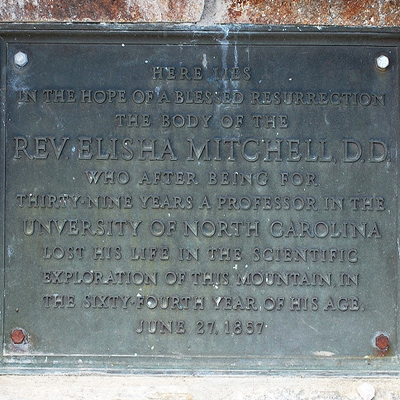
HERE LIES / IN THE HOPE OF A BLESSED RESURRECTION / THE BODY OF THE / REV. ELISHA MITCHELL, D.D. / WHO AFTER BEING FOR / THIRTY-NINE YEARS A PROFESSOR IN THE / UNIVERSITY OF NORTH CAROLINA / LOST HIS LIFE IN THE SCIENTIFIC / EXPLORATION OF THIS MOUNTAIN IN, / THE 64TH YEAR OF HIS AGE. / JUNE27, 1857.
National Park Service
September 28, 1928
35.766350 , -82.265430
View in Geobrowse
"Rev. Elisha Mitchell, D.D.," The Historical Marker Database, HMdb.org, (accessed October 28, 2015) Link
Blythe, John. “The Short Lived Monument to Elisha Mitchell,” North Carolina Miscellany, (accessed September 16, 2015) Link
Folder 1568: Yancey County: Mount Mitchell, circa 1920s: Scan 1, in the North Carolina County Photographic Collection #P0001, North Carolina Collection Photographic Archives, The Wilson Library, University of North Carolina at Chapel Hill, (accessed October 28, 2015) Link
Folder 1568: Yancey County: Mount Mitchell, circa 1920s: Scan 2, in the North Carolina County Photographic Collection #P0001, North Carolina Collection Photographic Archives, The Wilson Library, University of North Carolina at Chapel Hill, (accessed October 28, 2015) Link
Lewis, Jamie. “Mt. Mitchell, Where Mystery, Intrigue, and Forest History Meet!” From Peeling Back the Bark, Forest History Society, (accessed September 30, 2015) Link
Mewborn, Suzanne. "Elisha Mitchell," NCPedia.org, (accessed September 30, 2015) Link
Watson, Elgiva D. "Elisha Mitchell, 19 Aug. 1793-27 June 1857," Documenting the American South (from Dictionary of North Carolina Biography edited by William S. Powell), (accessed October 27, 2015) Link
“Towers of Mt. Mitchell.” From Vanished Places of the Southern Appalachians, April 12, 2008, (accessed September 30, 2015) Link
Yes
Bronze, stone
The original 1888 12 ft. tall Elisha Mitchell obelisk had been destroyed by strong winds in 1915
leaving his grave marked only by a stone cairn. A wooden temporary marker
stood at the head of the cairn
until the new memorial was dedicated in 1928.
The first lookout tower on Mt. Mitchell was built in 1916 and replaced by a stone tower
dedicated in 1927 with funding from C.J. Harris of Dillsboro. That tower was replaced in 1959. In
2009 a handicap-accessible observation deck replaced the 1959 tower. It was dedicated on May
9, 2009. Today the grave and overlook are in Mt. Mitchell State Park.
Mitchell, a professor at UNC had fallen to his death near a waterfall that now also bears his
name. The UNC professor was in Yancey County to measure the altitude of the mountain then
known as Black Dome. Prior to his death Mitchell had come under attack from a former
student at UNC and then Congressman Thomas Lanier Clingman for his claim that Black Dome was the
tallest peak in the eastern United States. Clingman had claimed that another mountain in the
Black Mountain range was taller. The dispute involved who had first identified what is now
known as Mt. Mitchell. Clingman claimed that Mitchell had identified another mountain that
was later named Clingman’s Dome. Mitchell’s claim to have identified the tallest mountain was
later bore out.
Originally buried in Asheville, Mitchell’s body was re-interred at the top of Mount Mitchell in June 1858. The burial site was marked by a simple cairn until 1888.
The memorial is located at Summit of Mt. Mitchell near Burnsville, NC.
Yes
 Know anything else about this monument that isn't mentioned here? If you have additional information on
this or any other monument in our collection fill out the form at the Contact Us link in the footer. Thank you.
Know anything else about this monument that isn't mentioned here? If you have additional information on
this or any other monument in our collection fill out the form at the Contact Us link in the footer. Thank you.