
Howard Monument: Battle of Round Mountain, Columbus
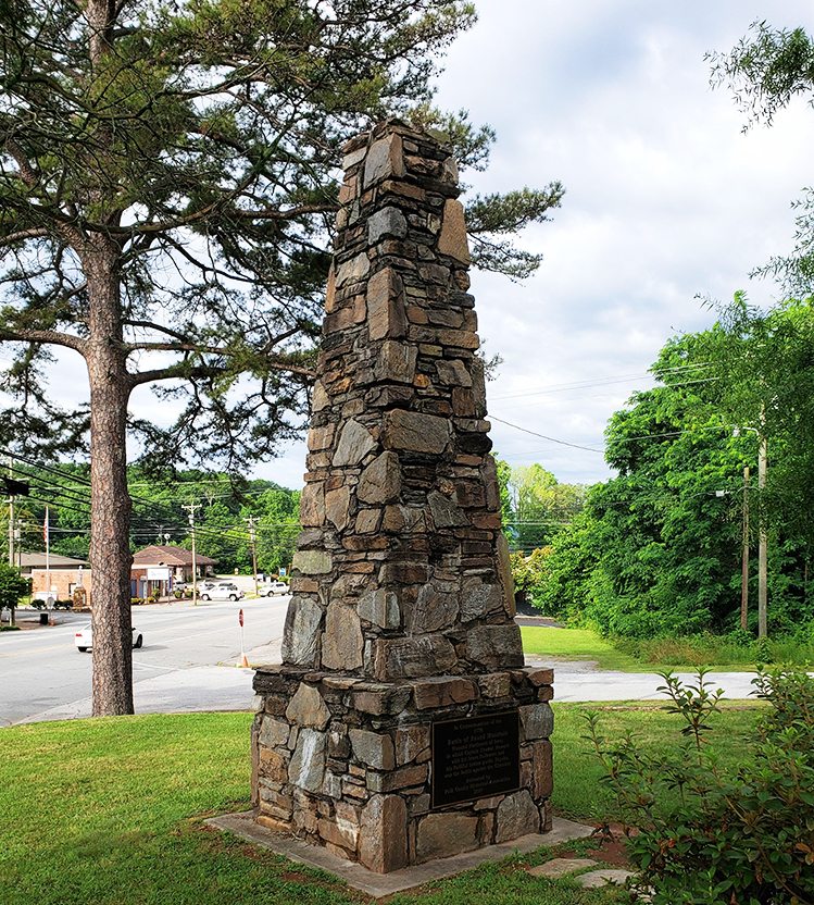
The monument is built of stone in the shape of an obelisk, 20 feet tall with an 8 feet wide base. News reports from 1908 describe its design as “rustic”. When constructed, granite inscription plaques adorned the monument. These were destroyed by vandals and a new bronze tablet placed in 1967. That 1967 tablet is no longer present. A bronze tablet commemorating the Battle of Round Mountain is on the front and a sponsor tablet on the rear. Both are from the memorial’s relocation and re-dedication at Stearns Park in 2007.
Images:
2007 Dedication Plaque |
Rear view of the obelisk |
Street view |
The obelisk in Stearns Park
IN COMMEMORATION OF THE / 1776 / BATTLE OF ROUND MOUNTAIN / (LOCATED NORTHWEST OF HERE) / IN WHICH CAPTAIN THOMAS HOWARD / WITH HIS BRAVE FOLLOWERS AND / HIS FAITHFUL INDIAN GUIDE, SKYUKA, / WON THE BATTLE AGAINST THE CHEROKEE / RELOCATED BY / POLK COUNTY HISTORICAL ASSOCIATION / 2007
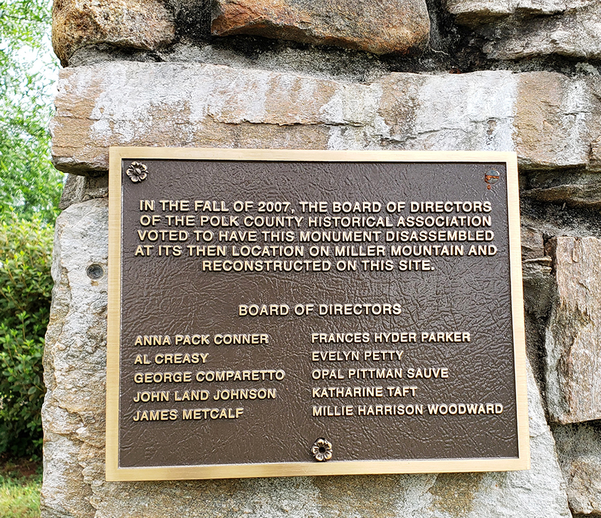
Sponsor Plaque: IN THE FALL OF 2007, THE BOARD OF DIRECTORS / OF THE POLK COUNTY HISTORICAL ASSOCIATION / VOTED TO HAVE THIS MONUMENT DISASSEMBLED / AT ITS THEN LOCATION ON MILLER MOUNTAIN AND / RECONSTRUCTED ON THIS SITE.
BOARD OF DIRECTORS / [Left column] ANNA PACK CONNER / AL CREASY / GEORGE COMPARETTO / JOHN LAND JOHNSON / JAMES METCALF /
[Right column] FRANCES HYDER PARKER / EVELYN PETTY / OPAL PITTMAN SAUVE / KATHRINE TAFT / MILLIE HARRISON WOODWARD
City of Columbus
1908 or 1909. Rededication: May 15, 1977 and November 31, 2007
35.252210 , -82.198700
View in Geobrowse
"Battle of Round Mountain. The Warriors Monument," The Historical Marker Database, HMdb.org, (accessed June 20, 2016) Link
"Battle of Round Mountain—Columbus in Polk, NC," Waymarking.com, (accessed June 1, 2015) Link
"Historic Places," polkcounty.org, (accessed June 25, 2014) Link
Gaut, Licia. “Dedication Ceremony Held for Thomas Howard Monument,” The Times-News (Hendersonville, NC), May 16, 1977, (accessed May 29, 2015) Link
Schulman, Mark. “Ceremony Rededicates Battle Monument,” The Times-News (Hendersonville, NC), November 30, 2007, (accessed May 29, 2022) Link
“Shaft in Howard Gap,” The Charlotte Observer (Charlotte, NC), May 23, 1908
“Shaft in Howard’s Gap,” The Chatham Record (Pittsboro, NC), June 24 1908
Yes
Local stone
The Tryon Council, No. 143, Junior Order United American Mechanics was the original sponsor in 1909. The Daughters of the American Revolution sponsored reassembly and relocation in 1977. The Polk County Historical Association sponsored reassembly and relocation in 2007.
News reports of the rededications indicated the monument was constructed in 1909, but it was actually constructed in 1908 with the dedication ceremony scheduled for July 4th. Rain forced cancellation and no stories of a later rededication were found.
The 1977 rededication was held on May 15 with approximately 100 descendants of Thomas Howard along with members of the South Carolina Society and Daughters of the American Revolution in attendance.
The 2007 rededication was held on November 31 with Anna Pack Conner, president of the Polk County Historical Association, giving a brief history of the battle at Round Mountain. Guest speakers included Columbus Mayor Kathleen McMillian, town Manager Tim Holloman and Polk County Board of Commissioners Chairman Tommy Melton with the Rev. John James Powell performing the invocation. A new plaque commemorating the Battle of Round Mountain was unveiled as part of the ceremony.
Warrior Mountain Monument
Capt. Thomas Howard (1760-1830) was described as an early adventurer and pioneer of the “dark corner” of north Greenville County, South Carolina. As the Cherokee resisted settler incursion into the area, Howard organized militia to protect the settlements. During the Revolutionary War and instigated by a Cherokee raid that left a farm family dead, Howard and a small command were guided by Skyuka through what is now known as Howard Gap. They came upon the Indians and their Tory allies from the rear in the Battle of Round Mountain, the last formal battle between local settlers and the Indians. Because of his loyalty to Captain Howard, Skyuka was considered as a traitor by his own people.
The monument as erected in 1908 or 1909 had two granite plaques that read: “To commemorate the battle of Round Mountain in which Capt. Thomas Howard and his brave followers with the faithful Indian guide Skyuka, defeated the Cherokee Nation 1776”. These plaques were destroyed by vandals and have been replaced in 1967 with one bronze plaque purchased by descendants of Howard. Photos of the 1967 plaque indicate the inscription was changed but difficult to read. It could not be determined if the 1967 plaque still exists or is associated with the monument.
Two stone mason companies, Superior Stone and Art Work, reassembled the monument at its current location in Sterns Park.
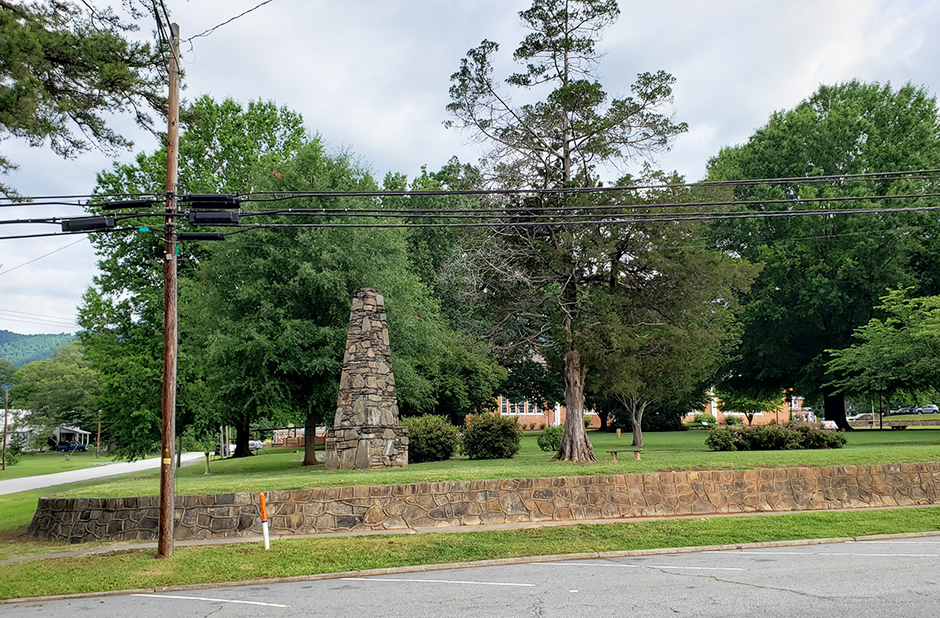
The obelisk is located in Stearns Park, at the corner of Hampton and E. Mills Streets, NC Route 108, Columbus, NC.
Several other memorials stand on or near the courthouse grounds, including Polk County WWI Doughboy, Polk County Bicentennial (Veterans) Memorial, Polk County War Memorial, Dr. Columbus Mills memorial and a Green Ashe tree memorial to veterans
of World War Two.
The monument stands on the lawn, surrounded by trees and bushes.
The first location was on the Howard Gap Road near Round Mountain on land owned by J.W. Kennedy. The exact site is unknown.
From 1968 until 1977 the monument was dismantled and placed in storage due to it being in the path of I-26 construction.
Once reassembled in 1977, it was located at 35.24971, -82.27335 to the side of Miller’s Mountain opposite Round Mountain.
 Know anything else about this monument that isn't mentioned here? If you have additional information on
this or any other monument in our collection fill out the form at the Contact Us link in the footer. Thank you.
Know anything else about this monument that isn't mentioned here? If you have additional information on
this or any other monument in our collection fill out the form at the Contact Us link in the footer. Thank you.


