Conestee Lost Settlement, Brevard
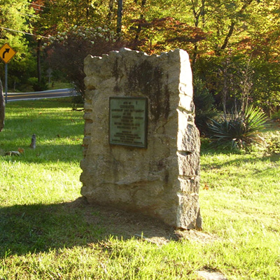
The Conestee Lost Settlement marker is a simple square bronze plaque attached to a large flat, roughly square shaped slab of stone embedded in the ground.
SITE OF / CONESTEE / LEGENDARY LOST SETTLEMENT / OF THE / ANCIENT CHEROKEE NATION / VISITED BY / BRITISH TROOPS IN 1725 / DISAPPEARED 1777
ERECTED BY CHEROKEE HISTORICAL ASS’N. / TRANSYLVANIA HISTORICAL ASS’N. / UNAKA CHAPTER / DAUGHTERS OF AMERICAN COLONISTS.
Transylvania County
July 1, 1958
35.183620 , -82.726570
View in Geobrowse
“Conestee,” The Historical Marker Database, HMdb.org, (accessed February 26, 2017) Link
“In Cherokee Legend, Lost Settlement Escaped White Man’s Invasion,” Asheville Citizen-Times (Asheville, NC), July 12, 1996
“Marker Noting Old Indian Village Will Be Unveiled,” Asheville Citizen-Times (Asheville, NC), June 30, 1958
“Plaque to Mark Site of Kanasta,” Asheville Citizen-Times (Asheville, NC), June 29, 1958
“The Legend of Kanasta,” Chenoctah’s Weblog, chenocetah.wordpress.com, (accessed February 26, 2017) Link
Yes
Bronze, boulder from Hickory Nut Gorge
Cherokee Historical Association, Transylvania County Historical Association and Unaka Chapter (#2) Daughters of American Colonists
Mrs. Ralph Ramsey, regent of the Unaka Chapter Daughters of American Colonists presided over the ceremony with Harry E. Buchanan, president of the Cherokee Historical Society as the principal speaker. Cherokee Indians dressed in period 1700’s costumes also participated in the ceremony.
Conestee (also known as Kanasta) was the only known Cherokee settlement between villages in the South Carolina foothills and North Carolina mountains further to the west. It is thought the settlement was abandoned around the 1750’s. Cherokee legend has it that two messengers from the Nunnehi, a legendary people whose villages were under the mountains, visited the Cherokees living at Kanasta. The visitors brought an invitation for the people of Kanasta to join them under Tsuwatelda, present day Pilot Mountain near Brevard, where they could live in peace. The Kanasta chief called a council of his people and they decided to accept the invitation. Upon reaching Tsuwatelda, a door opened inside of a cliff revealing a land of green pastures, woodlands and a village finer than those left behind. They alone of all the Cherokee Nation escaped the long wars and suffering that followed the white man’s invasion of the mountains.
The marker is located on the 3600 block of Greenville Highway (Hwy. 276) at the intersection with Island Ford Road several miles south of Brevard, NC.
The landscape is a mix of farm land and forest with scattered housing and several small businesses. Next to this marker is one for the Dunn’s Rock Masonic Lodge.
 Know anything else about this monument that isn't mentioned here? If you have additional information on
this or any other monument in our collection fill out the form at the Contact Us link in the footer. Thank you.

