Indian Trading Path Marker, Charlotte
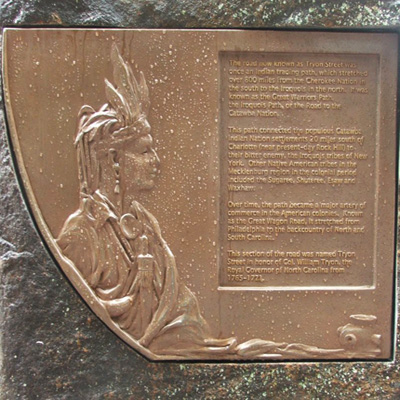
The Indian Trading Path marker is an upright granite stone with a rounded top and a bronze plaque inset into the front. The plaque has a rounded left side but is straight on all other edges, the bottom edge being shorter than the top edge. On the rounded site is a relief sculpture of a Catawba Indian. A small dedication plaque is inset into the rear.
THE ROAD NOW KNOWN AS TYRON STREET WAS / ONCE AN INDIAN TRADING PATH, WHICH STRETCHED / OVER 800 MILES FROM THE CHEROKEE NATION IN / THE SOUTH TO THE IROQUOIS IN THE NORTH. IT WAS / KNOWN AS THE GREAT WARRIORS PATH, THE IRO- / QUOIS PATH, OR THE ROAD TO THE CATAWBA / NATION.
THIS PATH CONNECTED THE POPULOUS CATAWBA / INDIAN NATION SETTLEMENTS 20 MILES SOUTH OF / CHARLOTTE (NEAR PRESENT-DAY ROCK HILL) TO / THEIR BITTER ENEMY THE IROQUOIS TRIBES OF NEW / YORK. OTHER NATIVE AMERICAN TRIBES IN THE / MECKLENBURG REGION IN THE COLONIAL PERIOD / INCLUDED THE SUGAREES, SHUTEREES, ESAWS AND / WAXHAWS.
OVER TIME THE PATH BECAME A MAJOR ARTERY OF / COMMERCE IN THE AMERICAN COLONIES. KNOWN / AS THE GREAT WAGON ROAD IT STRETCHED FROM / PHILADELPHIA TO THE BACKCOUNTRY OF NORTH AND / SOUTH CAROLINA.
THIS SECTION OF THE ROAD WAS NAMED TYRON / STREET IN HONOR OF COL. WILLIAM TYRON, THE / ROYAL GOVERNOR OF NORTH CAROLINA FROM / 1765-1771.
City of Charlotte
Circa 2015
35.224700 , -80.846500
View in Geobrowse
Yes
Bronze on granite
Mecklenburg Historical Association and The May 20th Society
The Liberty Hall monument was incorporated into the Charlotte Liberty Walk, a public/private partnership celebrating the revolutionary history of the City of Charlotte. This 1 mile trail dedicated in 2012 links important sites in the revolutionary history of Charlotte. The Trading Path is Marker 3 along the walk. Other markers include the Liberty Hall (Marker 4); Battle of Charlotte (Marker 1); Ishmael Titus (Marker 2); British Encampment plaque (Marker 6), and Queen Charlotte Walks in Her Garden sculpture (Marker 12).
The marker is located on the sidewalk at 401 South Tyron Street in Charlotte.
The marker stands between scarce trees planted along the street.
Guided and self-guided "Charlotte Liberty Walk" historic tours.
 Know anything else about this monument that isn't mentioned here? If you have additional information on
this or any other monument in our collection fill out the form at the Contact Us link in the footer. Thank you.

