
Driving Through Time - The Digital Blue Ridge Parkway

Search Results:
-
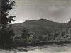
 Grandfather Mountain
1950s
-
 Linville Valley from Flat Rock Overlook
1950
-
 Chestoa View PO
1950
-
Parkway Land Use Map Section 2-J
1950
-
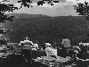
 Looking toward Grandfather from Flat Rock
1950
-
 Chestoa View PO
1950
-
 Grandfather Mountain
June 1950
-
Map Showing Lands of F.W. Hossfeld Heirs
1951
-
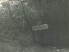 Existing Signs
February 1952
-
 Existing Entrance Bldgs and Gate
February 1952
Items in Query
Results: 548
Refine Your Search
Types (5)
Photographs (500) Newspaper Articles (44) Maps (2) Drawings, Plans, and Projections (1) Oral Histories (1)Locations (20)
Grandfather Mountain (291) Section 2J (65) Milepost 308 (39) Linville Falls (36) Beacon Heights (29) Linn Cove Viaduct (15) Milepost 317 (13) Milepost 305 (12) Chestoa View Parking Area (8) Flat Rock Overlook (8) Milepost 318 (8) Milepost 302 (6) Milepost 306 (5) Milepost 312 (4) Intersection of Blue Ridge Parkway at U.S. Route 221 (near Linville, N.C.) (3) Milepost 319 (2) Linville (1) Milepost 304 (1) Pilot Ridge (1) Section 2H (1)Sections (4)
2H (327) 2J (199) 2K (18) 2F (4)Counties (1)
Avery (548)

