
Driving Through Time - The Digital Blue Ridge Parkway

Search Results:
-
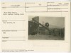
 View looking up from within the Mons Hotel property
October 24, 1936
-
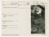
![View from [Sharp Top Mountain] toward north](https://docsouth.unc.edu/loris/blueridgeparkway/misc/0106_p_otter_mp_86a.jp2/full/100,75/0/default.jpg) View from [Sharp Top Mountain] toward north
View from [Sharp Top Mountain] toward north
October 24, 1936
-
 Blue Ridge Quarry, Hoist conveyor loading stone
March 15, 1937
-
 Existing building on top of Sharp Top, taken from highest point
October 29, 1938
-
 Fire tower and building on top of Sharp Top
October 29, 1938
-
 Peaks of Otter Existing Overnight Cabins and Collection Gate
October 29, 1938
-
 Fire hazard reduction work
May 17, 1939
-
 Proposed Dam site from East
May 17, 1939
-
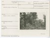 Hemlock Group on Sharp Top
May 26, 1939
-
 Proposed picnic area #2
May 26, 1939
Items in Query
Results: 480
Refine Your Search
Types (2)
Photographs (479) Drawings, Plans, and Projections (1)Locations (36)
Peaks of Otter (104) Sharp Top Mountain (Va.) (82) Peaks of Otter Lodge (Va.) (41) Peaks of Otter Bus Station and Camp Store (38) Peaks of Otter Visitor Center (30) Milepost 86 (27) Peaks of Otter Campground (21) Virginia State Route 43 at Little Stony Creek (17) Peaks of Otter Picnic Area (14) Section 1K (14) Sharp Top Overlook (9) Milepost 87 (8) Milepost 90 (8) Milepost 98 (7) Headforemost Mountain Overlook (6) Peaks of Otter Service Station (6) Flat Top Mountain (Va.) (5) Intersection of Blue Ridge Parkway at Virginia State Route 43 (4) Milepost 99 (4) Pine Tree Overlook (4) Sharp Top Mountain Bus Shelter (4) Bobblets Gap Overlook (3) Goose Creek Valley Overlook (3) Milepost 93 (3) Milepost 97 (3) Big Spring (Va.) (2) Milepost 95 (2) Powell Gap (2) Section 1J (2) Bearwallow Gap (1) Blue Ridge Quarry (1) Milepost 65 (1) Milepost 71 (1) Milepost 79 (1) Milepost 94 (1) Montvale Overlook (1)Sections (4)
1K (459) 1J (14) 1L (5) 1H (2)Counties (1)
Bedford (480)

