
Driving Through Time - The Digital Blue Ridge Parkway

Search Results:
-
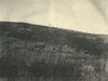
 Severe sheet and some gully erosion (after) see neg# 5436
November 1941
-
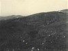
 Gully and Sheet Erosion
July 1, 1942
-
 Erosion to be controlled under 1944 S. & M.C.
October 6, 1943
-
 Erosion to be controlled under 1944 S. & M.C.
October 6, 1943
-
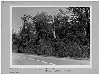
 "Before picture" shows close-up of severe sheet erosion. "After picture" neg #5443
August 1944
-
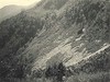
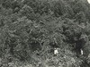
 Section 2J Before Selective Cutting
1946
-
 "After picture" shows same area controlled by pine brush mulching and seeding to Lespedeza sericea. Before picture neg# 5442
March 1946
-
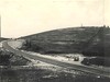
 Borrow pit obliteration after seeding and mulching
June 20, 1948
-
 Brush Clearing
August 8, 1974
-
 Richland Balsam Trail - Repair and construction
December 1976
Items in Query
Results: 64
Refine Your Search
Types (2)
Photographs (63) Oral Histories (1)Locations (22)
Milepost 430 (31) Milepost 268 (5) Milepost 267 (3) Section 2E (3) Craggy Mountains (2) Milepost 242 (2) Milepost 265 (2) Section 2A (2) Alligator Back (1) Craggy Knob (1) Heffner Gap (1) Milepost 225 (1) Milepost 229 (1) Milepost 237 (1) Milepost 245 (1) Milepost 261 (1) Milepost 264 (1) Milepost 269 (1) Milepost 354 (1) Moses H. Cone Memorial Park (1) Peaks of Otter Bus Station and Camp Store (1) Section 2J (1)Sections (11)
2W (31) 2E (15) 2C (5) 2A (4) 2P (3) 1K (1) 2D (1) 2G (1) 2J (1) 2K (1) 2N (1)Counties (10)
Haywood (31) Ashe (9) Alleghany (8) Wilkes (8) Buncombe (3) Avery (1) Bedford (1) Mitchell (1) Watauga (1) Yancey (1)

