
Driving Through Time - The Digital Blue Ridge Parkway

Search Results:
-
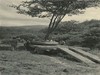
 Before bank sloping
1930s
-
 Clump maple
1930s
-
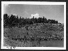
 Opposite Woodruff's
1930s
-
 Parking overlook
1930s
-
 Hare Mill Pond with hillside and buildings
1930s
-
 Hillside
1930s
-
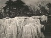 Ice Rock
1930s
-
 Trees loaded on trailer
1930s
-
 Building fire place, picnic area #1
1930s
-
 Trees on trailer
1930s
Items in Query
Results: 718
Refine Your Search
Types (1)
Photographs (718)Locations (52)
Section 2A (155) Section 2C (99) Cumberland Knob (51) Milepost 225 (31) Milepost 224 (28) Doughton Park (21) Milepost 242 (20) Milepost 217 (19) Milepost 237 (18) Milepost 218 (17) Milepost 227 (16) Milepost 228 (15) Milepost 229 (15) Milepost 241 (14) Milepost 226 (12) Milepost 221 (10) Milepost 222 (10) Milepost 240 (10) Milepost 230 (9) Milepost 231 (9) Milepost 232 (9) Bluffs (8) Hare Mill Pond (8) Milepost 219 (8) Milepost 238 (8) Milepost 239 (8) Junction of 2A/2B (7) Milepost 223 (7) Bluff Park (6) Devil's Garden (6) Pine Creek Bridge #4 (6) Section 2B (6) Milepost 234 (5) Milepost 247 (5) Alligator Back (4) Milepost 220 (4) Milepost 233 (4) Air Bellows Gap (3) Bull Head Mountain (3) Intersection of Blue Ridge Parkway and North Carolina State Route 18 (near Laurel Springs, N.C.) (3) R.L. Martin Tract (3) Basin Creek (2) Bluff Park Maintenance Area (2) Fox Hunters Paradise (2) Meadow Fork Valley (2) Milepost 244 (2) Roaring Gap (2) Roaring Gap Hotel (2) Alleghany County (1) Fishers Peak (1) Intersection of Blue Ridge Parkway at North Carolina State Route 18 (near Ennice, N.C.) (1) Mahogany Rock (1)Sections (3)
2A (425) 2C (232) 2B (54)Counties (1)
Alleghany (718)

