
Driving Through Time - The Digital Blue Ridge Parkway

Search Results:
-
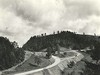
 County Road, vicinity of sec. 2D, looking south over ridges which carry parkway
August 1936
-
 Handlaid rock embankment
August 14, 1936
-
 Hand-laid rock embankment detail
August 14, 1936
-
 Early Construction
August 20, 1936
-
 Cabin within 100 foot right-of-way of the Parkway.
September 10, 1936
-
 View of log cabin in vicinity of parkway
September 10, 1936
-
 Right headwall culvert, Type 3
September 21, 1936
-
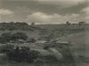
 Typical country road through North Carolina section of parkway. This is a usual road in good weather.
October 20, 1936
-
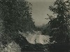
 View looking south along Parkway
November 11, 1936
-
 Culvert headwall
April 1, 1937
Items in Query
Results: 105
Refine Your Search
Types (1)
Photographs (105)Locations (26)
Milepost 251 (15) Section 2E (10) Section 2D (9) Sheets Cabin (9) Laurel Fork Viaduct (8) Milepost 268 (7) Milepost 248 (6) Milepost 257 (6) Milepost 261 (6) Milepost 250 (3) Milepost 256 (3) Milepost 263 (3) Milepost 252 (2) Milepost 255 (2) Milepost 264 (2) Milepost 266 (2) Milepost 271 (2) Northwest Trading Post (2) E.B. Jeffress Park (1) Gillam Gap (1) Intersection of Blue Ridge Parkway and North Carolina State Route 18 (near Laurel Springs, N.C.) (1) Milepost 262 (1) Milepost 267 (1) Milepost 269 (1) Section 2A (1) Sheets Gap Overlook (1)Sections (4)
2D (73) 2E (30) 2A (1) 2C (1)Counties (3)
Ashe (94) Wilkes (9) Alleghany (2)

