
Driving Through Time - The Digital Blue Ridge Parkway

Search Results:
-
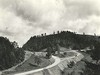
 County Road, vicinity of sec. 2D, looking south over ridges which carry parkway
August 1936
-
 Hand-laid rock embankment detail
August 14, 1936
-
 Hand-laid rock embankment construction
August 14, 1936
-
 Hand-laid rock embankment
August 14, 1936
-
 Handlaid rock embankment
August 14, 1936
-
 Early Construction
August 20, 1936
-
 Cabin within 100 foot right-of-way of the Parkway.
September 10, 1936
-
 View of log cabin in vicinity of parkway
September 10, 1936
-
 Property of Robert L. Doughton Opposite 2D
September 11, 1936
-
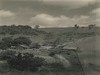
 View from right bank of road looking north showing a pine wooded area through which the parkway travels.
September 11, 1936
Items in Query
Results: 198
Refine Your Search
Types (2)
Photographs (193) Maps (5)Locations (24)
Milepost 248 (26) Laurel Fork Viaduct (22) Section 2D (22) Milepost 251 (15) Section 2E (13) Sheets Cabin (13) Milepost 268 (12) Milepost 261 (11) Northwest Trading Post (10) Milepost 257 (7) Milepost 250 (6) Milepost 255 (6) Milepost 262 (6) Milepost 263 (5) Gillam Gap (4) Milepost 252 (4) Milepost 256 (4) Laurel Springs (3) Daniels Gap (2) Milepost 259 (2) Sheets Gap Overlook (2) Milepost 258 (1) Milepost 260 (1) Old Route NC 16 (1)Sections (2)
2D (160) 2E (38)Counties (1)
Ashe (198)

